Transportation in Calgary
The city of Calgary, Alberta, has a large transportation network that encompasses a variety of road, rail, air, public transit, and pedestrian infrastructure. Calgary is also a major Canadian transportation centre and a central cargo hub for freight in and out of north-western North America. The city sits at the junction between the "Canamex" highway system and the Trans-Canada Highway (Highway 1 in Alberta).
As a prairie city, Calgary has never had any major impediments to growth. As such, it has developed into a city with an area of about 745 km2 (288 sq mi)[1] (of which only half is built up) and a metropolitan area of nearly 5,100 km2 (2,000 sq mi). This outward growth has encouraged the development of an extensive personal vehicle-oriented road network complete with a freeway system.
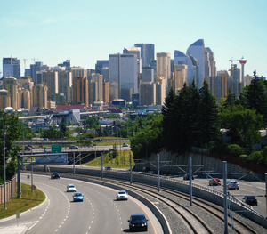
Since 1981, when the city officially opened the first leg of its CTrain rapid transit system, emphasis on public transportation as an alternative to cars has become important. The CTrain now has a higher ridership than any other light rail system in any other North American city with 309 900 boardings per weekday. Cycling is also seen as a major alternative to driving in Calgary. In recent years, increases in the population and density of inner city neighbourhoods such as the Beltline have favoured greater pedestrianism as well.
Public transportation
Calgary's primary public transportation system is operated by Calgary Transit. The service operates only within Calgary city limits and does not provide transportation to and from other communities within the Calgary Region. Some communities within Calgary's metropolitan area provide their own transit services (for example, Airdrie Transit). Calgary Transit is owned and managed by the City of Calgary.
Light rail

The light rail transit (LRT) system, known as the C-Train, consists of 58.5 km (36.4 mi) of track connecting 45[2] stations and was one of the first such systems in North America.[3] Until very recently, Calgary and Edmonton were the only two North American cities with populations under one million to operate rapid mass transit systems.
The Saddletowne-69 St. (Route 202) line serves the city's West, downtown and Northeast areas, while the Tuscany-Somerset–Bridlewood (Route 201) line runs between the Northwest and South Calgary via the 7th Avenue South transit-only corridor. Travel between stations along 7th Avenue in downtown is free-of-charge. Unique to the C-Train system, its power is completely wind generated and completely free of emissions.[4] An extension of the Route 202 line was recently built to serve some Southwest communities to the west of downtown. The project is called the WestLRT and was completed in December 2012.[5]
Buses
Calgary Transit also has a system of buses, with routes stretching over the whole city. It has won several awards for its efficiency and its environmental responsibility. It consists of over 160 bus routes and four C-Train lines (two routes), stretching over 4,500 km (2,800 mi).[6]
Roads and streets
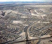
Calgary has an extensive street network. Smaller roads are supplemented with a number of major arteries, expressways and freeways. The largest of these is the north-south running Deerfoot Trail. The majority of main expressways and freeways are named Trails, as well as some of the main arterial roads that do not fit in the numbering grid. The use of the term Trails to describe major highways resulted from the development of early pioneer trails into the highways themselves. The original trails were named after the settlements to which they lead; for example, Edmonton Trail (part of the former Calgary and Edmonton Trail), (Fort) Macleod Trail, and Banff Trail (which combined with 24th Street W was later renamed Crowchild Trail). More recently developed local expressways were given the Trail moniker and have been named after important people from Calgary's history (Crowchild Trail, Marquis of Lorne Trail), native groups (Stoney Trail, Sarcee Trail, Blackfoot Trail) or again after their destination (Airport Trail). There are a couple of exceptions to this rule in which a few older residential streets have also been labeled "Trail", such as Morley Trail.
Plans originating in the 1950s and 1960s for a considerably more extensive freeway system including elevated freeways were largely abandoned in favour of a growing trend to reduce the emphasis on roads and increase the amount of public transportation infrastructure in North American cities.
Sidewalks at intersections in areas outside the downtown core are often stamped with the name of the cross-street, especially in older districts. As this was once done by hand by municipal employees who were not always literate, some street names are misspelled or the letters reversed.
Organization
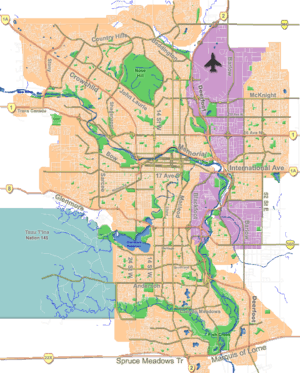
Traditionally Calgary's roads were built on a grid system. Originally, the streets and avenues were named, but after 1904, they were numbered.[7] Today, numbered Streets (running north-south) and Avenues (running east-west) dominate the city, although names appear to be making a comeback.[8] The city is divided into four quadrants: Northeast, Northwest, Southeast and Southwest, and all street names and addresses end with suffixes corresponding to the quadrant of the city in which they lie (NW, NE, SE or SW). The central point of the quadrant system is the Centre Street Bridge, with Centre Street and Centre Avenue forming the boundaries (although the points vary; most of the south end has Macleod Trail as a boundary, except near Chinook Centre where Macleod Trail bends westward; in the west end, the Bow River forms the boundary for the most part). Roads in predominantly suburban residential areas as well as freeways and expressways do not generally conform to the grid and are usually not numbered as a result (although some suburban streets are indeed numbered if they fall in place on the grid).
The main lines on the grid are fairly evenly distributed at intervals of about 1 mile (1.6 km) where an arterial road (or expressway) is usually situated (on former Township and Range Roads). They are at roughly the following Streets and Avenues (although not always named as such):
- Avenues north of downtown: 16th, 32nd, 48th, 64th, 80th, 96th, 112th, 128th, 144th
- Avenues south of downtown: 17th, 34th, 50th, 66th, 82nd, 90th, 114th, 130th, 146th, 162nd, 178th, 194th
- Streets east of downtown: 6th, 15th, 24th, 36th, 52nd, 68th, 84th
- Streets west of downtown: 14th, 24th, 37th, 53rd, 69th, 85th, 101st, 117th
A quirk of the numbering is that it was intended for addresses on numbered streets to begin at 100 (not 0) at Centre Street and Centre Avenue and move out accordingly. For example, 545 16th Avenue NW lies between 4th and 5th Streets NW. There are many violations of such, however, especially in suburban areas. The highest address numbers are found on north-south streets in the southernmost suburbs, where they approach 20000.
Major streets
- 6th Avenue S / 9th Avenue S (Highway 1A - part)
- 14th Street W
- 16th Avenue N (Highway 1 / Trans-Canada Highway)
- 17th Avenue SE (Highway 1A - part)
- 17th Avenue SW
- 36th Street E (becomes Métis Trail north of McKnight Boulevard)
- 52nd Street E (becomes Falconridge Boulevard north of McKnight Boulevard)
- Anderson Road
- Barlow Trail
- Blackfoot Trail
- Bow Trail
- Centre Street (becomes Harvest Hills Boulevard north of Beddington Trail)
- Country Hills Boulevard
- Crowchild Trail (Highway 1A - part)
- Deerfoot Trail (Queen Elizabeth II Highway / Highway 2)
- Elbow Drive
- Glenmore Trail (Highway 8 - part)
- Heritage Drive
- John Laurie Boulevard
- Macleod Trail (Highway 2A)
- McKnight Boulevard
- Memorial Drive
- Sarcee Trail
- Stoney Trail (Highway 201)
- Southland Drive
Skeletal road network
The city of Calgary designated major corridors to allow free flowing travel continuity throughout the city. With one exception (the central portion of 16th Avenue), they are all intended to be upgraded to freeways if they are not already.[9]
Roads designated as north-south corridors, from east to west, are:
- the East Freeway
- Deerfoot Trail
- Crowchild Trail-Glenmore Trail-14th Street-Anderson Road-Macleod Trail
- Stoney Trail-Highway 8-Glenmore Trail-Sarcee Trail.
Roads designated as east-west corridors from south to north, are:
- Highway 8-Glenmore Trail
- Trans-Canada Highway (16th Avenue N)
- Stoney Trail
Air
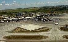
The Calgary International Airport (ICAO Code CYYC, IATA Code YYC) is the only international airport in the Calgary Region and one of only two in the province. The airport is WestJet Airlines's main base and largest hub, and acts as an Air Canada hub. In total, about 20 passenger airlines have regular scheduled flights to and from the airport. It is also a major hub for several cargo airlines including DHL, FedEx, Purolator, and United Parcel Service.
The airport primarily connects Western Canada with non-stop flights to Eastern Canada, 18 major American cities, as well as sun destinations in the Caribbean and Mexico. Calgary International airport also has regular scheduled service to London, Frankfurt, Amsterdam, Mexico City and Tokyo.[10]
Calgary International Airport is Canada's fourth busiest airport in after Toronto Pearson International Airport, Vancouver International Airport and Montreal Trudeau International Airport. In 2008, it served more than 12.5 million passengers and is expected to for several years.
Calgary's second airport, Calgary/Springbank Airport, is located in the western suburb of Springbank, handles the majority of private-plane flights, and acts as a reliever for the main airport.
Bus
Executive Express serves the Calgary-Edmonton corridor with a daily scheduled passenger transportation service aimed at the business commuter. Departing Calgary in the morning and returning to Calgary in the Afternoon, this is a unique service as passengers can either purchase seats or entire private compartments of four seats in the vehicle. This new concept allows business commuters to conduct meetings during travel time. Wireless internet among other amenities is included. Travel time is just under 3 hours, within 15 minutes of an on time airline flight. Edmonton morning departures soon available.
Scheduled bus service from Calgary or Calgary Airport and north to Red Deer and Edmonton are provided by Greyhound, Red Arrow, and Ebus. Some departures pickup at the Calgary Airport. South to Lethbridge are Greyhound, LA Shuttle, and Red Arrow. Calgary to Medicine Hat is provided by Greyhound, J&L Shuttle of Medicine Hat and Prairie Sprinter Shuttle of Medicine Hat. Greyhound provides service west to British Columbia. Banff Airporter and Brewster provides service between the Calgary Airport and Banff. Brewster also provides service to Lake Louise and Jasper. Travel to Montana USA is a charter van service provided by Airport Shuttle Express of Calgary as well as to Waterton Park, Fernie and other resort destinations in Alberta, BC and Montana. .
Rail
Passenger rail
Calgary is also the largest Canadian city without an Intercity Passenger Service, as all Via Rail service to the city was terminated in the late 1980s and early 1990s by the Conservative government. The Rocky Mountaineer and Royal Canadian Pacific rail tours serve Calgary from the former Via Rail station.
Freight
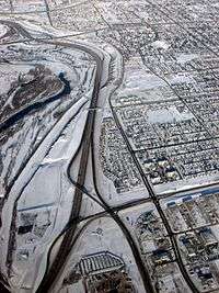
Calgary has four main Canadian Pacific and CN Rail lines that traverse the city, in addition to the various feeder lines that run through the industrial parks in the eastern half of the city. One of the rail structures in Calgary is the CPR Alyth Yard, where many of these feeder lines connect to the main lines.
Bicycle and pedestrian
The City of Calgary also maintains a network of paved multi-use pathways (for bicycling, roller skating and jogging). The dedicated pathway network in Calgary is among the most expansive in North America and spans 635 km (395 mi). There are also about 290 km (180 mi) of signed on-street bicycle routes.[11] The pathways connect many of the city's parks, river valley, residential neighbourhoods, and downtown. Calgarians make year-round use of these paths for walking, running, and cycling to various destinations. In June 2005, massive flooding destroyed much of the pathway system (including many pedestrian bridges) along the Elbow and Bow rivers. Most repairs are complete.
Calgary's system of elevated walkways or skyways downtown (known as the +15 system) is the most extensive in the world.[12] These walkways not only serve to connect buildings, but also contain restaurants, shops, and services (most notably incorporating large parts of The Core Shopping Centre). The system is 16 km (9.9 mi) long.
See also
References
- ↑ http://content.calgary.ca/CCA/City+Hall/Business+Units/Development+and+Building+Approvals+and+Land+Use+Planning+and+Policy/Land+Use+Planning/Current+Studies+and+Ongoing+Activities/Annexation+Information/Comparing+Calgary+With+New+York.htm
- ↑ C-Train
- ↑ LRT Technical Data Archived July 6, 2006, at the Wayback Machine.
- ↑ Calgary Transit and the Environment
- ↑ West LRT in Calgary Main Website
- ↑ Calgary Transit Statistics Archived July 7, 2006, at the Wayback Machine.
- ↑ "The Odd History of Calgary's City Streets". SmartCalgaryHomes.com. Retrieved June 23, 2009.
- ↑ "Calgary's Missing Street Names". UrbanPhoto.net. Retrieved June 23, 2009.
- ↑ City of Calgary (February 2005). "The Calgary Transportation Plan". Retrieved 2007-05-25.
- ↑ Calgary International Airport
- ↑ Map of Bicycle pathways
- ↑ http://www.calgary.ca/portal/server.pt/gateway/PTARGS_0_0_766_234_0_43/http%3B/content.calgary.ca/CCA/City+Transportation/Get+Around+Calgary/Walking/Plus+15.htm
External links
- City of Calgary: Transportation Planning
- Calgary Transit
- Calgary International Airport
- Canadian Pacific Railway