Alberta Highway 2A

Segments of Highway 2A in Alberta

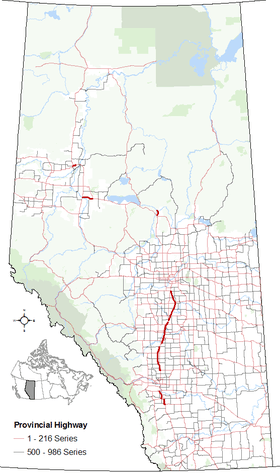
Alberta Provincial Highway No. 2A[1] is the designation of six alternate routes off Highway 2 in Alberta, Canada. In general, these are original sections of Highway 2, such as the southern portion of Macleod Trail in Calgary. They passed through communities before limited-access freeways were built to shorten driving distance, accommodate heavier volumes and to bypass city traffic. Portions of the alignment of Highway 2A follow the route of the former Calgary and Edmonton Trail.

Highway 2A north of Crossfield in the foreground with divided Highway 2 in the distance.
Downtown Red Deer from the air with Highway 2A twin bridges crossing the Red Deer River.

High River – Calgary

Alberta Highway 2A shield

Highway 2A
Route information
Length: 46 km (29 mi)
Major junctions
South end: Hwy 23 in High River
  Hwy 7
North end: Hwy 22X / Hwy 201 in Calgary
Location
Specialized
and rural
municipalities:
Foothills No. 31 M.D.
Major cities: Calgary
Towns: High River, Okotoks
Highway system

Provincial highways in Alberta

Hwy 2Hwy 2A

Route description

Highway 2A currently begins in the Town of High River and follows 12 Avenue SE and Centre Street before passing by Aldersyde and intersecting Highway 7. The highway then travels westward to the Town of Okotoks, where it branches north and follows Southridge Drive and Northridge Drive through Okotoks before rejoining Highway 2 near De Winton. The highway and shares a common alignment with Highway 2 for 3 km until it splits to Deerfoot Trail (Highway 2) and Macleod Trail (Highway 2A) and ends in the City of Calgary at Highway 22X (Spruce Meadows Trail) / Highway 201 (Stoney Trail). Macleod Trail continues north into downtown Calgary but does not carry a highway designation.[2][3]

History

Highway 2A originally began at Highway 2 at the locality Connemara, located 8 km north of the Town of Nanton, and travelled through High River, Aldersyde, and Okotoks, before terminating at Highway 2. The section between Connemara and High River was dropped by the province in 1997.[4][5] In 2003, Highway 2A was extended north via Macleod Trail when Highway 2 was rerouted to the newly opened Deerfoot Trail extension.

Major intersections

Rural/specialized municipalityLocationkm[3]miDestinationsNotes
M.D. of Foothills No. 31Connemara−20−12 Hwy 2 Calgary, Fort Macleod, Lethbridge50°23′52″N 113°49′30″W / 50.397659°N 113.824956°W / 50.397659; -113.824956 (2A km -20)
Cayley−14−8.7Osler Street50°27′01″N 113°51′03″W / 50.450216°N 113.850777°W / 50.450216; -113.850777 (2A km -20)
−10−6.2 Hwy 540 Bar U Ranch National Historic Site50°29′04″N 113°51′03″W / 50.484551°N 113.850900°W / 50.484551; -113.850900 (2A km -10)
High River00.0 Hwy 23 east (12 Avenue SE) to Hwy 2 (Exit 194) Vulcan
10 Street SE
Hwy 2A begins and travels westward
50°34′19″N 113°51′03″W / 50.572042°N 113.850824°W / 50.572042; -113.850824 (2A km 0)
21.2Centre Street
12 Avenue SE
Roundabout
Hwy 2A branches north
50°34′19″N 113°52′21″W / 50.572010°N 113.872595°W / 50.572010; -113.872595 (2A km 2)
31.9Crosses Highwood River50°34′59″N 113°52′21″W / 50.58308°N 113.87239°W / 50.58308; -113.87239 (2A:04 km 3)
42.5 Hwy 543 west / 498 Avenue E Longview50°36′04″N 113°52′56″W / 50.601227°N 113.882151°W / 50.601227; -113.882151 (2A km 4)
Aldersyde159.3 Hwy 7 east to Hwy 547 east Mossleigh
To Hwy 2 (Exit 209)
Hwy 7 concurrency begins
Hwy 2A turns west
50°41′41″N 113°53′33″W / 50.694713°N 113.892531°W / 50.694713; -113.892531 (2A km 15)
Okotoks191232 Street E50°42′10″N 113°57′07″W / 50.702735°N 113.951824°W / 50.702735; -113.951824 (2A km 19)
2113 Hwy 783 south / Southridge Drive north
Hwy 7 west Black Diamond, Turner Valley
Hwy 2A branches north
Hwy 7 concurrency ends
50°42′10″N 113°58′30″W / 50.702683°N 113.974968°W / 50.702683; -113.974968 (2A km 21)
2314Crosses Sheep RiverBecomes Northridge Drive
50°43′19″N 113°58′55″W / 50.721968°N 113.982068°W / 50.721968; -113.982068 (2A km 23)
2415 Hwy 549 west (Elizabeth Street) Millarville50°43′33″N 113°58′56″W / 50.725898°N 113.982158°W / 50.725898; -113.982158 (2A km 24)
3119290 Avenue E – De Winton50°47′27″N 113°58′29″W / 50.790894°N 113.974700°W / 50.790894; -113.974700 (2A km 31)
3321 Hwy 2 south (Exit 222) Fort Macleod, Lethbridge
Hwy 552 east
Interchange
Hwy 2A branches northwest
Hwy 2 concurrency begins
50°47′55″N 113°58′05″W / 50.798660°N 113.967953°W / 50.798660; -113.967953 (2A km 33)
3622 Hwy 2 north (Deerfoot Trail / Exit 225) CalgaryPartial Interchange
Northbound exit, southbound entrance
Hwy 2 concurrency ends
50°49′30″N 113°59′54″W / 50.82500°N 113.99833°W / 50.82500; -113.99833 (2A km 36)
3924Dunbow Road50°50′02″N 114°00′28″W / 50.833865°N 114.007864°W / 50.833865; -114.007864 (2A km 39)
City of Calgary4125 Hwy 552 south (226 Avenue S) De WintonCalgary city limits
Southbound exit/entrance
50°50′56″N 114°01′27″W / 50.848816°N 114.024056°W / 50.848816; -114.024056 (2A km 41)
4629 Hwy 201 east (Stoney Trail / Exit 5)
Hwy 22X west (Spruce Meadows Trail)
Interchange
Hwy 2A ends
50°53′33″N 114°03′16″W / 50.892575°N 114.054431°W / 50.892575; -114.054431 (2A:08 km 46)
Continues as Macleod Trail to Calgary City Centre
1.000 mi = 1.609 km; 1.000 km = 0.621 mi

Crossfield – Bowden

Alberta Highway 2A shield

Highway 2A
Route information
Length: 66 km (41 mi)
Major junctions
South end: Hwy 2 / Hwy 72 near Crossfield
  Hwy 27
North end: Hwy 587 in Bowden
Location
Specialized
and rural
municipalities:
Rocky View County, Mountain View County, Red Deer County
Towns: Crossfield, Carstairs, Olds, Bowden
Highway system

Provincial highways in Alberta

Hwy 2AHwy 2A

Route description

Highway 2A starts at the Highway 2 / Highway 72 interchange (Exit 295) and passes through the Town of Crossfield, Town of Carstairs, and by the Town of Didsbury before entering the Town of Olds along 46 Avenue and intersects Highway 27 (46 Street). The highway continues north to the Town of Bowden before terminating at Highway 587, just west of Highway 2 (Exit 357).[2][3]

Major intersections

Rural/specialized municipalityLocationkm[3]miDestinationsNotes
Rocky View County00.0 Hwy 2 (Exit 295) Calgary, Red Deer, Edmonton
Hwy 72 east Beiseker, Drumheller
Interchange
Hwy 2A begins
51°23′14″N 114°00′07″W / 51.387327°N 114.001875°W / 51.387327; -114.001875 (2A km 0)
21.2Dickson Stevenson Trail – Airdrie51°23′34″N 114°01′31″W / 51.392777°N 114.025167°W / 51.392777; -114.025167 (2A km 2)
Crossfield63.7 Hwy 574 west Madden51°25′52″N 114°01′29″W / 51.431113°N 114.024696°W / 51.431113; -114.024696 (2A km 6)
116.8Acme Road (Township Road 292) – Acme
To Hwy 2 (Exit 305)
51°28′29″N 114°01′44″W / 51.474746°N 114.028930°W / 51.474746; -114.028930 (2A km 11)
Mountain View County1912 Hwy 580 west Cremona51°32′00″N 114°04′29″W / 51.533196°N 114.074617°W / 51.533196; -114.074617 (2A km 19)
Carstairs1912 Hwy 581 east / Gough Road51°33′43″N 114°05′43″W / 51.562036°N 114.095266°W / 51.562036; -114.095266 (2A km 19)
3421 Hwy 582 Didsbury51°39′50″N 114°05′45″W / 51.663997°N 114.095967°W / 51.663997; -114.095967 (2A km 34)
Olds4830 Hwy 27 (46 Street) Sundre, Three Hills51°47′42″N 114°05′46″W / 51.795070°N 114.096212°W / 51.795070; -114.096212 (2A km 48)
Red Deer County6239 Hwy 2 (Exit 353)Access from southbound Hwy 2 only
Hwy 2A turns northwest
51°54′27″N 114°01′38″W / 51.907367°N 114.027175°W / 51.907367; -114.027175 (2A km 62)
Bowden6641 Hwy 587 Red Lodge Provincial Park
To Hwy 2 (Exit 357) Calgary, Red Deer, Edmonton
Hwy 2A ends
Adjacent to Hwy 2/587 interchange
51°56′19″N 114°01′54″W / 51.938647°N 114.031739°W / 51.938647; -114.031739 (2Akm 66)
1.000 mi = 1.609 km; 1.000 km = 0.621 mi

Innisfail – Leduc

Alberta Highway 2A shield

Highway 2A
Route information
Length: 150 km (90 mi)
Major junctions
South end: Hwy 2 / Hwy 590 in Innisfail
  Hwy 42
Hwy 11
Hwy 11A
Hwy 12
Hwy 53
Hwy 13
North end: Hwy 2 in Leduc
Location
Specialized
and rural
municipalities:
Red Deer County, Lacombe County, Ponoka County, Wetaskiwin No. 10 County, Leduc County
Major cities: Red Deer, Lacombe, Wetaskiwin, Leduc
Towns: Innisfail, Penhold, Blackfalds, Ponoka, Millet
Highway system

Provincial highways in Alberta

Hwy 2AHwy 2A

Route description

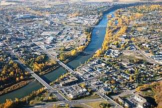
Highway 2A in begins in the Town of Innisfail at Highway 590 (50 Street), just west of Highway 2 (Exit 368), along 42 Avenue. The highway continues north and passes through the Town of Penhold before entering the City of Red Deer along Tayler Drive. The highway turns east along 19 Street and then north along Gaetz Avenue. Highway 2A splits into one-way couplets through downtown Red Deer, with northbound traffic following 49 Avenue and southbound traffic following portions of Gaetz Avenue and 51 Avenue. After crossing the Red Deer River, the one-way streets rejoin and intersect Highway 11 (67 Street) and Highway 11A, which forms Red Deer’s northern city limit. The highway continues north through the Town of Blackfalds and City of Lacombe. North of Lacombe, the highway rejoins Highway 2 and share the same alignment for 5 km before the highway branches northeast and passes through hamlet of Morningside, Town of Ponoka, and hamlet of Maskwacis. The highway enters the City of Wetaskiwin along 56 Street and continues north through the Town of Millet, by the hamlet of Kavanagh, and before it rejoins Highway 2 (Exit 516) in the City of Leduc.

Major intersections

Rural/specialized municipalityLocationkm[3]miDestinationsNotes
Red Deer CountyInnisfail00.0 Hwy 590 east (50 Street) / 42 Avenue Big Valley
To Hwy 2 (Exit 368) Edmonton, Red Deer, Calgary
42 Avenue
Hwy 2A begins
Adjacent to Hwy 2/590 interchange
52°01′39″N 113°56′03″W / 52.027451°N 113.934092°W / 52.027451; -113.934092 (2A km 0)
Penhold148.7 Hwy 42 east / Hwy 592 west Pine Lake52°07′23″N 113°52′20″W / 52.123099°N 113.872312°W / 52.123099; -113.872312 (2A km 14)
Springbrook1711 Airport Drive (Township Road 372) – Red Deer Regional Airport52°10′19″N 113°51′43″W / 52.171912°N 113.861825°W / 52.171912; -113.861825 (2A km 17)
2113McKenzie Road (Township Road 374)52°12′06″N 113°50′54″W / 52.201644°N 113.848252°W / 52.201644; -113.848252 (2A km 21)
2415 To Hwy 2 south (Exit 394) Calgary52°13′44″N 113°49′30″W / 52.229005°N 113.824921°W / 52.229005; -113.824921 (2A km 24)
City of Red Deer24.515.2 To Hwy 2 north / 19 Street Edmonton
Taylor Drive
Hwy 2A branches east
52°14′04″N 113°49′17″W / 52.2343278°N 113.821498°W / 52.2343278; -113.821498 (2A km 25)
2516Gaetz Avenue
Hwy 590 east (19 Street) Delburne
Hwy 2A branches north
52°13′58″N 113°48′50″W / 52.232646°N 113.813893°W / 52.232646; -113.813893 (2A km 25)
To Hwy 2 south (Exit 394) CalgaryAccess to Hwy 2 south closed during interchange construction.
Access from Hwy 2 north to Hwy 2A still open.[6]
271732 Street52°15′03″N 113°48′50″W / 52.250760°N 113.813927°W / 52.250760; -113.813927 (2A km 27)
2918Ross Street52°16′08″N 113°48′41″W / 52.269009°N 113.811471°W / 52.269009; -113.811471 (2A km 29)
3019Crosses Red Deer River52°16′38″N 113°48′43″W / 52.277320°N 113.811848°W / 52.277320; -113.811848 (2A km 30)
3119 Hwy 11 (67 Street) Stettler, Sylvan Lake, Rocky Mountain House52°17′18″N 113°48′50″W / 52.288458°N 113.813843°W / 52.288458; -113.813843 (2A km 31)
Red Deer CountyRed Deer3522 Hwy 11A west Sylvan Lake
↑/↓4025Crosses Blindman River52°21′24″N 113°47′46″W / 52.356600°N 113.796205°W / 52.356600; -113.796205 (2A km 40)
Lacombe CountyBlackfalds4125 Hwy 597 JoffreRoundabout
52°22′05″N 113°47′43″W / 52.368186°N 113.795400°W / 52.368186; -113.795400 (2A km 41)
4528Lakeside / Sargent Road (Township Road 400)52°24′18″N 113°47′10″W / 52.404958°N 113.786226°W / 52.404958; -113.786226 (2A km 45)
City of Lacombe5333 Hwy 12 (50 Avenue) Gull Lake, Bentley, Stettler52°27′47″N 113°43′44″W / 52.463106°N 113.728864°W / 52.463106; -113.728864 (2A km 53)
Lacombe County6037 Hwy 2 south (Exit 431) Red Deer, Calgary
Township Road 412 (Milton Road) east
Interchange
Hwy 2 concurrency begins
52°30′24″N 113°41′18″W / 52.506702°N 113.688459°W / 52.506702; -113.688459 (2A km 60)
6540 Hwy 2 north (Exit 437) EdmontonInterchange
Hwy 2 concurrency ends
52°33′32″N 113°39′46″W / 52.559023°N 113.662835°W / 52.559023; -113.662835 (2A km 65)
Morningside6842 Hwy 597 west52°34′47″N 113°38′11″W / 52.579812°N 113.636455°W / 52.579812; -113.636455 (2A km 68)
Ponoka County7848Crosses Battle River52°39′33″N 113°36′10″W / 52.659051°N 113.602854°W / 52.659051; -113.602854 (2A km 78)
Ponoka7949 Hwy 53 Rimbey, Bashaw52°40′25″N 113°35′42″W / 52.673584°N 113.594991°W / 52.673584; -113.594991 (2A km 79)
Samson I.R. No. 137Maskwacis9861 Hwy 611 east Ferintosh, New NorwayHwy 611 concurrency begins
52°49′14″N 113°27′25″W / 52.820554°N 113.457046°W / 52.820554; -113.457046 (2A km 98)
Ermineskin I.R. No. 13810163 Hwy 611 westHwy 611 concurrency ends
52°50′36″N 113°26′23″W / 52.843424°N 113.439851°W / 52.843424; -113.439851 (2A km 101)
City of Wetaskiwin1157140 Avenue
Hwy 13 west / Hwy 613 east Ma-Me-O Beach, Winfield
Hwy 13 concurrency begins
52°57′35″N 113°23′24″W / 52.959805°N 113.390079°W / 52.959805; -113.390079 (2A km 115)
11873 Hwy 13 east CamroseHwy 13 concurrency ends
52°59′20″N 113°23′24″W / 52.988931°N 113.390007°W / 52.988931; -113.390007 (2A km 118)
County of Wetaskiwin No. 10Millet13081 Hwy 616 west (45 Avenue) / Township Road 475 MulhurstHwy 616 concurrency begins
53°05′26″N 113°28′10″W / 53.090681°N 113.469407°W / 53.090681; -113.469407 (2A km 130)
Leduc County13685 Hwy 616 east ArmenaHwy 616 concurrency ends
53°08′01″N 113°27′53″W / 53.133697°N 113.464599°W / 53.133697; -113.464599 (2A km 136)
Kavanagh14188service roadKavanagh south entrance
53°10′40″N 113°30′54″W / 53.177871°N 113.514954°W / 53.177871; -113.514954 (2A km 141)
14288service roadKavanagh north entrance
53°11′10″N 113°31′04″W / 53.186120°N 113.517868°W / 53.186120; -113.517868 (2A km 142)
14389Glen Park Road (Township Road 490)53°11′33″N 113°31′12″W / 53.192385°N 113.520113°W / 53.192385; -113.520113 (2A km 143)
City of Leduc1489250 Street north / Southfork Drive west53°14′38″N 113°32′25″W / 53.243969°N 113.540244°W / 53.243969; -113.540244 (2A km 148)
15093 Hwy 2 (Exit 516) Edmonton, Red Deer, CalgaryInterchange
Hwy 2A ends
53°15′09″N 113°33′31″W / 53.252437°N 113.558612°W / 53.252437; -113.558612 (2A km 150)
1.000 mi = 1.609 km; 1.000 km = 0.621 mi
  •       Closed/former
  •       Concurrency terminus

Smith

Alberta Highway 2A shield

Highway 2A
Route information
Length: 15 km (9 mi)
Major junctions
South end: Hwy 2 near Hondo
North end: Smith
Location
Specialized
and rural
municipalities:
Lesser Slave River No. 124 M.D.
Highway system

Provincial highways in Alberta

Hwy 2AHwy 2A

Route description

Highway 2A, known as Highway 2A:44 by Alberta Transportation, begins Highway 2 near the hamlet of Hondo and connects with hamlet of Smith.[2]

Major intersections

Rural/specialized municipalityLocationkm[3]miDestinationsNotes
M.D. of Lesser Slave River No. 12400.0 Hwy 2 Slave Lake, Peace River, Athabasca, EdmontonHwy 2A begins
55°03′19″N 114°03′36″W / 55.055324°N 114.059917°W / 55.055324; -114.059917 (2A:44 km 0)
Hondo31.9road55°04′11″N 114°01′45″W / 55.069835°N 114.029114°W / 55.069835; -114.029114 (2A:44 km 3)
Smith159.3roadHwy 2A ends
55°09′48″N 114°02′18″W / 55.163336°N 114.038459°W / 55.163336; -114.038459 (2A:44 km 15)
1.000 mi = 1.609 km; 1.000 km = 0.621 mi

High Prairie

Alberta Highway 2A shield

Highway 2A
Route information
Length: 27 km (17 mi)
Major junctions
East end: Hwy 2 at Triangle
West end: Hwy 49 near Guy
Location
Specialized
and rural
municipalities:
Big Lakes County, Smoky River No. 130 M.D.
Highway system

Provincial highways in Alberta

Hwy 2AHwy 2A

Route description

Highway 2A, known as Highway 2A:54 by Alberta Transportation, begins at Highway 2 at the locality of Triangle, 15 km west of the Town of High Prairie, and connects with Highway 49 near the hamlet of Guy.[2] Prior to 1990, this section was signed as Highway 2 but was renumbered at the same time that Highway 34 was renumbered to Highway 43 (present day Highway 49) north of the Town of Valleyview.[7][8]

Major intersections

Rural/specialized municipalityLocationkm[3]miDestinationsNotes
Big Lakes CountyTriangle00.0 Hwy 2 north McLennan, Donnelly, Peace River
Hwy 2 east High Prairie, Slave Lake, Edmonton
Hwy 2A begins
56°13′59″N 117°28′41″W / 56.232989°N 117.477933°W / 56.232989; -117.477933 (2A:54 km 0)
M.D. of Smoky River No. 13063.7 Hwy 747 south Sunset House55°25′58″N 116°48′49″W / 55.432852°N 116.813600°W / 55.432852; -116.813600 (2A:54 km 6)
2717 Hwy 49 Valleyview, Donnelly, Peace RiverHwy 2A ends
55°27′47″N 117°08′17″W / 55.463066°N 117.137919°W / 55.463066; -117.137919 (2A:54 km 27)
1.000 mi = 1.609 km; 1.000 km = 0.621 mi

Grimshaw

Alberta Highway 2A shield

Highway 2A
Route information
Length: 11 km (7 mi)
Major junctions
East end: Hwy 2 at Roma Junction
West end: Hwy 2 in Grimshaw
Location
Specialized
and rural
municipalities:
Peace No. 135 M.D.
Towns: Grimshaw
Highway system

Provincial highways in Alberta

Hwy 2AHwy 3

Route description

Highway 2A, known as Highway 2A:36 by Alberta Transportation, begins at Highway 2 at the locality of Roma Junction, 13 km west of the Town of Peace River, and terminates in the Town of Grimshaw,[2] where it passes by Mile Zero monument of the Mackenzie Highway.

Major intersections

Rural/specialized municipalityLocationkm[3]miDestinationsNotes
M.D. of Peace No. 135Roma Junction00.0 Hwy 2 Grimshaw, Peace River, EdmontonHwy 2A begins
56°13′59″N 117°28′41″W / 56.232989°N 117.477933°W / 56.232989; -117.477933 (2A:36 km 0)
Grimshaw116.8 Hwy 2 Fairview, Grande Prairie, Peace RiverHwy 2A ends
56°11′28″N 117°36′40″W / 56.191193°N 117.611064°W / 56.191193; -117.611064 (2A:36 km 11)
1.000 mi = 1.609 km; 1.000 km = 0.621 mi

See also

References

  1. Provincial Highways Designation Order, Alberta Transportation, p. 1
  2. 1 2 3 4 5 "2015 Provincial Highways 1 - 216 Series Progress Chart" (pdf). Alberta Transportation. March 2015. Retrieved 2016-03-30.
  3. 1 2 3 4 5 6 7 8 Google Maps. (2016). Retrieved from https://www.google.com/maps.
  4. Province of Alberta Canada 1996 Official Road Map (Map). Alberta Tourism and Small Business. § M-5.
  5. Province of Alberta Canada 1997 Official Road Map (Map). Alberta Tourism and Small Business. § M-5.
  6. "Gaetz Avenue Interchange: Detours and alternate access". Alberta Transportation. Government of Alberta. August 22, 2016. Retrieved November 23, 2016.
  7. Province of Alberta Canada 1989 Official Road Map (Map). Alberta Tourism and Small Business. § F-3, G-3.
  8. Province of Alberta Canada 1990 Official Road Map (Map). Alberta Tourism and Small Business. § F-3, G-3.

External links

This article is issued from Wikipedia - version of the 11/23/2016. The text is available under the Creative Commons Attribution/Share Alike but additional terms may apply for the media files.