Trencsén County
| Trencsén County Comitatus Trenchiniensis Trencsén vármegye Komitat Trentschin Trenčianska župa | |||||
| County of the Kingdom of Hungary | |||||
| |||||
|
Coat of arms | |||||
 | |||||
| Capital | Trencsén 48°54′N 18°2′E / 48.900°N 18.033°ECoordinates: 48°54′N 18°2′E / 48.900°N 18.033°E | ||||
| History | |||||
| • | Established | 9th century | |||
| • | Treaty of Trianon | June 4, 1920 | |||
| Area | |||||
| • | 1910 | 4,456 km2 (1,720 sq mi) | |||
| Population | |||||
| • | 1910 | 310,437 | |||
| Density | 69.7 /km2 (180.4 /sq mi) | ||||
| Today part of | Slovakia | ||||
| Trenčín is the current name of the capital. | |||||

Trencsén county (Latin: comitatus Trentsiniensis / Trenchiniensis; Hungarian: Trencsén (vár)megye; Slovak: Trenčiansky komitát / Trenčianska stolica / Trenčianska župa; German: Trentschiner Gespanschaft / Komitat) was an administrative county (comitatus) of the Kingdom of Hungary. Its territory is now in western Slovakia.
Geography
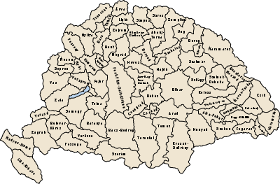
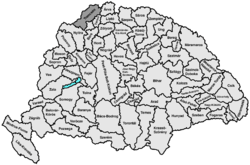
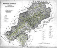
Trencsén county shared borders with the Austrian lands Moravia and Galicia and the Hungarian counties Árva, Turóc and Nyitra. The county's territory was a strip in the extreme northwestern edge of present-day Slovakia, i.e. the territory between the Czech border, the town of Vágújhely, the Turóc county, the Árva county and the Polish border. The river Vág flowed through the county. Its area was 4456 km² around 1910.
Capitals
The capital of Trencsén County was the Trenčín Castle (Hungarian: Trencséni vár), and from around 1650 the town of Trencsén.
History
A predecessor of the Trenčín county existed already in the 9th century, at the time of Great Moravia. Its center was in Ducové. In the 10th and 11th century, the county was probably temporarily part of Bohemia and then temporarily of Poland (castellania Trecen).
The Trencsén county as a Hungarian comitatus arose at the end of the 11th century, when most parts of the territory were conquered by the Kingdom of Hungary. Traditionally, the office of hereditary lord lieutenant of Trencsén county was held by the Csák, Cseszneky and Illésházy families.
In the aftermath of World War I, Trencsén county became part of newly formed Czechoslovakia, as recognized by the concerned states in 1920 by the Treaty of Trianon. The Trenčín county (Trenčianska župa) continued to exist until 1922, but it had completely different powers, etc.
When Slovakia became independent temporarily between 1939 and 1945, the Trenčín county was created again in 1940, but its territory was slightly extended. After World War II Trenčín county was in Czechoslovakia again. In 1993, Czechoslovakia was split and Trenčín became part of Slovakia.
Demographics
1900
In 1900, the county had a population of 287,665 people and was composed of the following linguistic communities:[1]
Total:
- Slovak: 266,763 (92.7%)
- German: 10,213 (3.6%)
- Hungarian: 8,210 (2.9%)
- Romanian: 105 (0.0%)
- Croatian: 64 (0.0%)
- Serbian: 60 (0.0%)
- Ruthenian: 16 (0.0%)
- Other or unknown: 2,234 (0.8%)
According to the census of 1900, the county was composed of the following religious communities:[1]
Total:
- Roman Catholic: 250,628 (87.1%)
- Lutheran: 24,890 (8.7%)
- Jewish: 11,397 (4,0)
- Calvinist: 447 (0.2%)
- Greek Orthodox: 147 (0.0%)
- Greek Catholic: 141 (0.0%)
- Unitarian: 3 (0.0%)
- Other or unknown: 12 (0.0%)
1910
In 1910, the county had a population of 310,437 people and was composed of the following linguistic communities:[1]
Total:
- Slovak: 284,770 (91.8%)
- Hungarian: 13,204 (4.3%)
- German: 9,029 (2.9%)
- Romanian: 172 (0.0%)
- Croatian: 78 (0.5%)
- Serbian: 51 (0.0%)
- Ruthenian: 24 (0.0%)
- Other or unknown: 3,109 (1.0%)
According to the census of 1910, the county was composed of the following religious communities:[1]
Total:
- Roman Catholic: 271,233 (87.4%)
- Lutheran: 27,421 (8.8%)
- Jewish: 10,809 (3,5)
- Calvinist: 584 (0.2%)
- Greek Orthodox: 198 (0.1%)
- Greek Catholic: 176 (0.0%)
- Unitarian: 9 (0.0%)
- Other or unknown: 7 (0.0%)
Subdivisions
In the early 20th century, the subdivisions of Trencsén county were:
| Districts (járás) | |
|---|---|
| District | Capital |
| Bán | Bán, SK Bánovce nad Bebravou |
| Csaca | Csaca, SK Čadca |
| Illava | Illava, SK Ilava |
| Kiszucaújhely | Kiszucaújhely, SK Kysucké Nové Mesto |
| Nagybiccse | Nagybiccse, SK Bytča |
| Puhó | Puhó, SK Púchov |
| Trencsén | Trencsén, SK Trenčín |
| Vágbeszterce | Vágbeszterce, SK Považská Bystrica |
| Zsolna | Zsolna, SK Žilina |
| Urban districts (rendezett tanácsú város) | |
| Trencsén, SK Trenčín | |
References
- 1 2 3 4 "KlimoTheca :: Könyvtár". Kt.lib.pte.hu. Retrieved 2012-06-24.
External links
-
 "Trentschin". The American Cyclopædia. 1879.