U.S. Route 401
| |||||||
|---|---|---|---|---|---|---|---|
 | |||||||
| Route information | |||||||
| Auxiliary route of US 1 | |||||||
| Length: | 251.0 mi[1][2][3] (403.9 km) | ||||||
| Existed: | 1957 – present | ||||||
| Major junctions | |||||||
| South end: |
| ||||||
|
| |||||||
| North end: |
| ||||||
| Location | |||||||
| States: | South Carolina, North Carolina | ||||||
| Highway system | |||||||
| |||||||

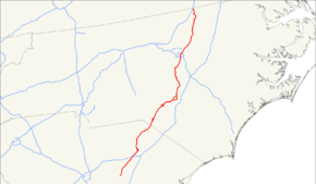
U.S. Route 401 (US 401) is a north–south United States highway, a spur of U.S. Route 1, that traverses along the fall line from Sumter, South Carolina to Interstate 85 near Wise, North Carolina.
Route description
Starting in Sumter, South Carolina, US 401 goes northeast through mostly swamp and farmland, as it connect the cities of Darlington and Bennettsville before crossing the state line into North Carolina. Traversing the state for 77.2 miles (124.2 km), it is mostly a two-lane rural road, which is likely to only have local traffic along it thanks to nearby Interstate 95.[2]
In North Carolina, the highway becomes more utilized, as it connect to several mid-size and large cities in the state. In the sandhills region, it connects the cities of Laurinburg, Raeford, and Fayetteville, all three of which have business routes connecting the downtown areas. The road is typically two-lane still, but expands to four-lane (or more) in each city. The road takes a pause in the lime-light as it straddles nearby Interstate 95 again; from Fayetteville, through Lillington, to Fuquay-Varina.
In Wake County, US 401 is center-stage again as a major north-south corridor, connecting bedroom communities to downtown Raleigh. Once it leaves the county, it reverts to a rural road connecting the small cities of Louisburg and Warrenton. US 401 finally ends at Interstate 85, just north from the community of Wise; competing a 173.8-mile (279.7 km) thru the state.[3]
Overall, the route goes through endless fields of farmland broken now and then by cities and small towns. With exceptions to both the sandhills region and Wake County, most travelers would be better served using Interstate 95.
History
US 401 was established in 1957 as a renumbering of US 15A, from Sumter to Raleigh, and NC 59, from Raleigh to Norlina; it is the third and current route to bear the name.
In 1967, northbound US 401 was rerouted along South Street west onto McDowell Street, formally using Lenoir Street, in Raleigh.[4] Same year, US 401 was rerouted onto bypass route northwest of downtown Fayetteville, replacing part of NC 59; its old alignment became US 401 Business.[5] In 1971, US 52/US 401 was placed on new bypass northwest of Darlington; its old alignment became US 52 Business.[6] In 1984, US 401 was rerouted along the eastern half of the Raleigh Beltline (Tom Bradshaw Freeway and Cliff Benson Beltway); its former alignment through downtown Raleigh was downgraded to secondary roads. In 1991, US 401 was rerouted back through downtown Raleigh after I-440 was established along the entire Raleigh Beltline.[7][8] In 2001, US 401 was extended north, in concurrency with US 1, to its current northern terminus to I-85, north of Norlina.[9][10] On July 16, 2015, US 401 was placed onto new four-lane superstreet alignment bypassing east of Rolesville; its former alignment through downtown Rolesville became US 401 Business.[11][12]
The first US 401 existed between 1926-1931, solely in Virginia, it was replaced by US 52. The second US 401 existed between 1932-1934, in North Carolina and South Carolina, it was replaced by US 15 and US 15A.
Future
Considered an important link between Fayetteville, Lillington and Raleigh, NCDOT has set up the US 401 Corridor Study. The purpose of the study is to identify deficiencies in the existing corridor and develop alternatives for accommodating future growth in traffic volumes (i.e. widen to multi-lanes). The corridor study also includes NC 55 and NC 210. Estimated costs for all road improvements along the corridor is around $193–222.6 million. Property acquisition and construction is unfunded at this time.[13][14][15]
Junction list
| State | County | Location | mi[2][3] | km | Destinations | Notes |
|---|---|---|---|---|---|---|
| South Carolina | Sumter | Sumter | 0.0 | 0.0 | ||
| 0.5 | 0.80 | |||||
| 1.9 | 3.1 | |||||
| Lee | Saint Charles | 12.6 | 20.3 | |||
| Elliott | 17.1 | 27.5 | ||||
| | 18.6 | 29.9 | ||||
| Darlington | Lamar | 24.5 | 39.4 | Main Street / Lee State Park Road – Lee State Park | ||
| | 27.4 | 44.1 | ||||
| | 28.0 | 45.1 | ||||
| Darlington | 37.8 | 60.8 | South end of US 52 overlap | |||
| 38.2 | 61.5 | |||||
| | 41.1 | 66.1 | ||||
| | 52.3 | 84.2 | South end of US 15 overlap | |||
| Society Hill | 54.3 | 87.4 | North end of US 52 overlap | |||
| Marlboro | | 61.3 | 98.7 | |||
| Bennettsville | 64.6 | 104.0 | ||||
| 65.6 | 105.6 | North end of SC 9/38 overlap | ||||
| 66.5 | 107.0 | South end of SC 38 overlap | ||||
| 67.6 | 108.8 | South end of SC 9 overlap | ||||
| | Proposed interchange[16][17] | |||||
| McColl | 75.6 | 121.7 | ||||
| 77.2 0.0 | 124.2 0.0 | South Carolina–North Carolina state line | ||||
| North Carolina | Scotland | Laurinburg | 5.2 | 8.4 | ||
| 5.8 | 9.3 | South end of US 501 overlap | ||||
| 7.0 | 11.3 | |||||
| 8.8 | 14.2 | North end of US 15/US 501 overlap | ||||
| 9.8 | 15.8 | |||||
| Wagram | 16.8 | 27.0 | To John Charles McNeill House | |||
| Hoke | Raeford | 26.9 | 43.3 | |||
| 27.2 | 43.8 | |||||
| | 31.4 | 50.5 | ||||
| Cumberland | Fayetteville | 43.8 | 70.5 | |||
| 46.3 | 74.5 | All American Expressway – Fort Bragg, Pope Army Airfield | ||||
| 47.1 | 75.8 | |||||
| 49.4 | 79.5 | |||||
| 51.7 | 83.2 | |||||
| 55.2 | 88.8 | |||||
| | 64.3 | 103.5 | ||||
| Harnett | Lillington | 74.9 | 120.5 | South end of NC 210 overlap | ||
| 75.0 | 120.7 | West end of NC 27 overlap | ||||
| 75.4 | 121.3 | North end of US 421 overlap; to Raven Rock State Park | ||||
| 77.0 | 123.9 | South end of US 421, east end of NC 27, and north end of NC 210 overlap | ||||
| Wake | Fuquay Varina | 89.7 | 144.4 | West end of NC 42 overlap | ||
| 90.5 | 145.6 | West end of NC 55 overlap | ||||
| 92.5 | 148.9 | East end of NC 42/NC 55 overlap | ||||
| Garner | 103.8 | 167.0 | East end of US 70 and south end of NC 50 overlap | |||
| Raleigh | 104.8 | 168.7 | Wilmington Street – Downtown Raleigh | |||
| 105.5 | 169.8 | |||||
| 106.7 | 171.7 | Martin Luther King Jr Boulevard / Western Boulevard | ||||
| 108.2 | 174.1 | Peace Street | ||||
| 108.7 | 174.9 | West end of US 70 and north end of NC 50 overlap | ||||
| 108.8 | 175.1 | Fairview Avenue | Northbound left exit, no northbound entrance | |||
| 109.5 | 176.2 | North Wake Forest Road | No southbound exit | |||
| 109.7 | 176.5 | South Wake Forest Road / Atlantic Avenue | ||||
| 111.2 | 179.0 | South end of US 1 overlap | ||||
| 113.5 | 182.7 | North end of US 1 overlap | ||||
| 115.9 | 186.5 | SPUI | ||||
| | 125.5 | 202.0 | ||||
| Franklin | | 127.4 | 205.0 | |||
| Louisburg | 136.9 | 220.3 | West end of NC 56 overlap | |||
| 137.6 | 221.4 | South end of NC 39 overlap | ||||
| 138.5 | 222.9 | East end of NC 56 overlap | ||||
| 139.1 | 223.9 | |||||
| Ingleside | 144.0 | 231.7 | North end of NC 39 overlap | |||
| Warren | Warrenton | 162.3 | 261.2 | East end of US 158 Business overlap | ||
| Norlina | 165.5 | 266.3 | East end of US 158 and west end of US 158 Business overlap | |||
| 166.7 | 268.3 | South end of US 1 and west end of US 158 overlap | ||||
| | 173.8 | 279.7 | Continuation as US 1 | |||
1.000 mi = 1.609 km; 1.000 km = 0.621 mi
| ||||||
Bannered routes
See also
- Black River
- Cape Fear River
- Cross Creek Mall
- Lumber River
- Lynches River
- Neuse River
- Pee Dee River
- Raleigh Convention Center
- Tar River
References
- ↑ Robert V. Droz (14 November 2006). "Termini and Lengths in Miles". U. S Highways: From US 1 to (US 830). Robert V. Droz. Retrieved October 1, 2007.
- 1 2 3 Google (February 26, 2013). "US 401 in South Carolina" (Map). Google Maps. Google. Retrieved February 26, 2013.
- 1 2 3 Google (November 29, 2011). "US 401 in North Carolina" (Map). Google Maps. Google. Retrieved November 29, 2011.
- ↑ "Route Change (1967-03-09)" (PDF). North Carolina Department of Transportation. March 9, 1967. Retrieved August 2, 2015.
- ↑ "Route Changes (1967-11-03)" (PDF). North Carolina Department of Transportation. November 3, 1967. Retrieved August 2, 2015.
- ↑ U.S. Route Numbering Subcommittee (November 6, 1970). "U.S. Route Numbering Subcommittee Agenda Showing Action Taken by the Executive Committee" (PDF) (Report). Houston, TX: American Association of State Highway Officials. p. 6. Retrieved August 2, 2015 – via Wikimedia Commons.
- ↑ Tabb, John R. (June 10, 1991). "Report of the Special Committee on U.S. Route Numbering to the Executive Committee" (PDF) (Report). Lake Lanier Islands, GA: American Association of State Highway and Transportation Officials. p. 3. Retrieved August 2, 2015.
- ↑ "Route Changes (1991-07-16)" (PDF). North Carolina Department of Transportation. July 16, 1991. Retrieved August 2, 2015.
- ↑ Special Committee on U.S. Route Numbering (May 19, 2001). "Report of the Special Committee on U.S. Route Numbering to the Standing Committee on Highways" (PDF) (Report). Wichita, KS: American Association of State Highway and Transportation Officials. p. 3. Retrieved August 2, 2015.
- ↑ "Route Changes (2001-06-29)" (PDF). North Carolina Department of Transportation. June 29, 2001. Retrieved August 2, 2015.
- ↑ "Special Committee on U. S. Route Numbering - Louisville, Kentucky - Report to SCOH" (DOC). AASHTO. May 29, 2014. Retrieved May 30, 2014.
- ↑ WTVD Staff (July 16, 2015). "DOT opens 6-mile long Rolesville Bypass". Durham, NC: WTVD. Retrieved July 25, 2015.
- ↑ "NCDOT: US 401 Corridor Study". Retrieved November 28, 2011.
- ↑ "NCDOT: US 401 Corridor Study Project Map" (PDF). Retrieved November 28, 2011.
- ↑ "NCDOT: Project R-2609". Retrieved November 28, 2011.
- ↑ Staff. "Project Status: Northern Project". I-73 Environmental Impact Study. South Carolina Department of Transportation. Retrieved February 26, 2013.
- ↑ I-73 Northern Map (PDF) (Map). South Carolina Department of Transportation. Bennettsvile inset. Retrieved February 26, 2013.
External links
-
 Media related to U.S. Route 401 at Wikimedia Commons
 - End of US Route 401
- Mapmikey's South Carolina Highways Page: US 401
- NCRoads.com: U.S. 401