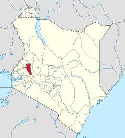
Uasin Gishu County
| Uasin Gishu County | ||
|---|---|---|
| County | ||
|
Great Rift Valley viewed from somewhere near Eldoret | ||
| ||
 Location in Kenya | ||
| Country |
| |
| Formed | 4 March 2013 | |
| Capital | Eldoret | |
| Government | ||
| • Governor | Jackson Mandago | |
| Area | ||
| • Total | 2,955.3 km2 (1,141.0 sq mi) | |
| Population (2009) | ||
| • Total | 894,179 [1] | |
| Time zone | EAT (UTC+3) | |
| Website | uasingishu.go.ke | |
Uasin Gishu County is one of the 47 counties of Kenya, located in the former Rift Valley Province. The city of Eldoret (capital and largest town in the county) is the county's administrative and commercial centre.
Uasin Gishu is located on a plateau and has a cool and temperate climate. It borders Trans-Nzoia County, Kenya.
Naming
Its name comes from the Illwuasin-kishu Maasai clan. The land was the grazing area of the clan. They surrendered the land to the colonial government in the Anglo-Maasai agreement of 1911, and were subsequently pushed towards Trans Mara. The plateau that they once occupied was then registered in its Anglicised version, Uasin Gishu.[2]
Local authorities
| Town | Type | Population (2009) | Rank in Kenya (Population Size) |
|---|---|---|---|
| Eldoret | Municipality | 289,380 | 5 |
| Moi’s Bridge | Town | 14,596 | 106 |
| Matunda | Town | 10,031 | 119 |
| Burnt Forest | Town | 4,925 | 172 |
| Jua Kali | Town | 3,427 | 192 |
| Turbo | Town | 2,831 | 201 |
Historical
In 1903, the area was proposed as a potential Jewish homeland, as the British Uganda Programme.
In 1908, fifty eight families of Afrikaans-speaking South Africans settled in Uashin Gishu plateau. They were followed by sixty more families in 1911 and more later.[3] The town of Eldoret was established in the midst of the farms they created.
Administrative divisions
| Division | Population* | Urban pop.* | Headquarters |
|---|---|---|---|
| Ainabkoi | 77,290 | 18,799 | Ainabkoi |
| Kapsaret | 93,162 | 55,056 | Kapsaret |
| Kesses | 84,894 | 0 | Kesses |
| Moiben | 92,717 | 6,172 | Moiben |
| Soy | 165,127 | 46,338 | Eldoret |
| Turbo | 109,508 | 46,900 | Turbo |
| * 1999 census. Sources: , , | |||
Constituencies
The county has six constituencies:
- Ainabkoi Constituency
- Moiben Constituency
- Turbo Constituency
- Soi Constituency
- Kapseret Constituency
- Kesses Constituency
References
- ↑ http://www.scribd.com/doc/36672705/Kenya-Census-2009
- ↑ MORRIS KIRUGA. Daily Nation. How local dialects influenced naming of west Kenya towns. 23 July 2013
- ↑ Red strangers: the white tribe of Kenya, ISBN 1-85725-206-3, by Christine Stephanie Nicholls
External links
Coordinates: 0°31′00″N 35°17′00″E / 0.516667°N 35.2833°E

