Villa Rica, Georgia
| Villa Rica, Georgia | ||
|---|---|---|
| City | ||
|
City Hall on Bankhead Highway | ||
| ||
| Nickname(s): The City of Gold | ||
 Location in Carroll County and the state of Georgia | ||
| Coordinates: 33°43′55″N 84°55′12″W / 33.73194°N 84.92000°WCoordinates: 33°43′55″N 84°55′12″W / 33.73194°N 84.92000°W | ||
| Country | United States | |
| State | Georgia | |
| Counties | Carroll, Douglas | |
| Hixtown | 1826 | |
| Villa Rica | 1881 | |
| Named for | The local gold rush | |
| Government | ||
| • Mayor | J. Allen Collins | |
| Area | ||
| • Total | 14.4 sq mi (37.3 km2) | |
| • Land | 14.2 sq mi (36.9 km2) | |
| • Water | 0.2 sq mi (0.4 km2) | |
| Elevation | 1,138 ft (347 m) | |
| Population (2010) | ||
| • Total | 13,956 | |
| • Density | 980/sq mi (378.4/km2) | |
| Time zone | EST (UTC-5) | |
| • Summer (DST) | EDT (UTC-4) | |
| ZIP code | 30180 | |
| Area code(s) | 770/678/470 | |
| FIPS code | 13-79528[1] | |
| GNIS feature ID | 0333333[2] | |
| Website |
www | |

Villa Rica /ˌvɪləˈrɪkə/ is a city in Carroll and Douglas counties in the U.S. state of Georgia. The population was 4,134 at the 2000 census. By the 2010 census, the population had grown to 13,956,[3] an increase of approximately 238%.
Geography
Location
Villa Rica is located in northeastern Carroll County and northwestern Douglas County at 33°43′55″N 84°55′12″W / 33.73194°N 84.92000°W (33.731909, -84.919982).[4] U.S. Route 78 (Bankhead Highway) passes through the center of the city, leading west 6 miles (10 km) to Temple and east 10 miles (16 km) to Douglasville. Interstate 20 passes through the southern part of the city with access from exits 24 and 26, and leads east 32 miles (51 km) to Atlanta and west 55 miles (89 km) to Oxford, Alabama.
According to the United States Census Bureau, the city has a total area of 14.4 square miles (37.3 km2), of which 14.2 square miles (36.9 km2) is land and 0.15 square miles (0.4 km2), or 1.04%, is water.[3] Villa Rica sits on the ridgeline that separates the Chattahoochee and the Tallapoosa river basins. Slightly more than half of Villa Rica lies within Carroll County, and the remainder lies within Douglas County.
Climate
Villa Rica has a humid subtropical climate (Cfa) according to the Köppen classification system, with hot, humid summers and mild to chilly winters. On average, the warmest month is July. The highest recorded temperature was 103 °F (39 °C) in 1980. On average, the coolest month is January. The lowest recorded temperature was −9 °F (−23 °C) in 1985. The most precipitation on average occurs in March.[5] Despite its significant physical distance from the Gulf of Mexico (250 miles) and the Atlantic Ocean (260 miles), on rare occasion Villa Rica is impacted by hurricanes, sometimes severely. Tornadoes are a more common occurrence in the area, although not usually as severe as the those that occur in the midwest United States.
| Monthly Normal and Record High and Low Temperatures for Villa Rica, Georgia | ||||||||||||
| Month | Jan | Feb | Mar | Apr | May | Jun | Jul | Aug | Sep | Oct | Nov | Dec |
|---|---|---|---|---|---|---|---|---|---|---|---|---|
| Rec High °F | 81 | 80 | 93 | 92 | 96 | 100 | 103 | 102 | 100 | 97 | 86 | 81 |
| Norm High °F | 52 | 57 | 65 | 72 | 79 | 85 | 88 | 87 | 82 | 73 | 64 | 55 |
| Norm Low °F | 29 | 31 | 38 | 44 | 53 | 61 | 66 | 65 | 59 | 46 | 38 | 31 |
| Rec Low °F | -9 | 3 | 9 | 24 | 30 | 36 | 47 | 48 | 32 | 23 | 2 | 0 |
| Precip (in) | 5.53 | 5.07 | 6.22 | 4.38 | 4.16 | 3.86 | 4.53 | 3.70 | 3.21 | 3.36 | 4.55 | 4.44 |
| Source: The Weather Channel[5] | ||||||||||||
History
The location which was to become Villa Rica was originally settled in 1826 along what is now Dallas Highway. This land was ceded by the Creek people in 1825 with the second Treaty of Indian Springs signed by Chief William McIntosh. In 1826, farmers and gold miners arrived in the area from Pennsylvania, New Jersey and Delaware to what was then known as "Hixtown" (named after a local tavern operator, incorporated in 1830). One mile south was Chevestown, owned by Allison Cheeves. Hixtown and Cheevestown moved to Villa Rica's present location in 1882 when the railroad was built. Many of the original structures were physically moved to the new site (now known as the North Villa Rica Commercial Historic District) by rolling them on logs pulled by horses.[6] The city was incorporated as Villa Rica in 1881. The name Villa Rica is derived from the Spanish for "rich village", and the city's name change was done to help promote the gold that had been found in the area.
Old Villa Rica (Hixtown)
Shortly after the arrival of the wagons in 1826, gold was discovered there.[7] 1826 was also the year that Carroll County was created and named for Charles Carroll of Carrollton, Maryland, because he was the last living signer of the Declaration of Independence. Although it did not develop into the large gold rush that would strike Georgia a few years later, there was a small gold rush in Villa Rica in the late 1820s. When the Georgia Gold Rush took hold in 1829, most of the Villa Rica miners moved northeast to the Dahlonega area. Villa Rica was established in 1830. Nevertheless, some mining continued in the area, with several hundred men employed in nearby mines. In 1832, Hixtown had over 2,000 residents (60% of the county’s population). Gold lots were $500 per acre compared to $2 per acre for land elsewhere in the county. There were at least 19 active gold mines.[6] By 1860, the gold supplies in the area had been largely exhausted.
Early Villa Rica had a Wild West atmosphere complete with Indians, horse thieves, and vigilante justice. The Creek Indian village was located on Sweetwater Creek east of town. They were hunters, not warriors, and were friendly toward the white settlers, eventually taking on work among the settlers. Townspeople were invited to Creek celebrations including a three-day festival held each autumn with lots of food and activities. At some point later in the 1830s, the Creeks moved to either Arkansas or Oklahoma, but local records are unclear whether or not this was by choice or part of the Trail of Tears.[8]
The local horse thieves were known as the Pony Club, and the vigilantes were the Slicks. At first, the Slicks would just hold Pony Club members caught stealing horses until a jury trial could be held. But Pony Club members usually had no trouble finding witnesses to prove their innocence, so the Slicks eventually started holding their own trials and the guilty were whipped. Things came to a head during the election of 1832 when large numbers of Pony Club members and Slicks got into a brawl. The Slicks won the fight, and the Pony Club demanded a grand jury try the Slicks on charges of assault and battery with intent to kill. However, the jury ended up commending the Slicks and thanking them for their work.[8]
New Villa Rica

With the arrival of the new railroad line, Hixtown and Cheevestown combined to become the new city of Villa Rica. The first train rolled through town in June 1882. A round-trip ticket from the Union Passenger Depot in Atlanta was only $1.00.[8]
This young community experienced two disastrous fires almost immediately. The first fire occurred in the business section on Montgomery Street in 1890. An entire block of stores composed entirely of wooden buildings was destroyed. The second fire occurred Monday night, July 27, 1908. The fire was bolstered by heating oil and chemicals from the drug store in which it started. Because of the strength of the fire, much of the focus was on saving the stock of the affected stores. In all, one quarter of Villa Rica's business district was destroyed in three hours. In 1957 an explosion caused by a gas leak destroyed four buildings and killed 12 people.[8][9]
The Bankhead Highway was surveyed and eventually passed though Villa Rica in 1917. Named for Alabama Senator John Hollis Bankhead, it was the second transcontinental highway in the United States and the first all-weather one. In the 1930s it was rerouted though town taking down the Velvin Hotel and extending Montgomery Street westward. It was a main east-west route through the area until Interstate 20 opened in December 1977.[10]
On 14 May 1961, Freedom Riders passed through Villa Rica.[11]
Historic sites
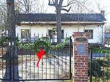
- Wicks Tavern (c. 1830) is the oldest commercial structure in Carroll County.[12] The tavern was built in Hixtown by New York immigrant John B. Wick. Wick's Tavern was a local gathering place for gold miners working area mines in the early 19th century. The building is a classic example of the "Dutch"-style timber framing method. When the Georgia Pacific Railway passed through town in 1882 and the homes and businesses were moved, the tavern was considered too large to be moved. It was later turned into a home. In 1998, the "Friends of Wick's Tavern" raised the funds necessary to rescue this historic building from being demolished and finally helped it make the journey to downtown Villa Rica.[13] Wicks Tavern now serves as a living history museum and the home of Forrest Escort SCV and the Friends of Wicks Tavern.
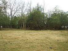
- The Stockmar Gold Mine (19th-20th centuries) is presently being preserved as a city park and gold museum currently under the name Pine Mountain Gold Museum at Stockmar Park.[14] As a division of Villa Rica Parks and Recreation, the museum was opened in 2008 and serves as a historical landmark for the city.[15]
- Fullerville (1916-1956) is a small community northwest of Villa Rica which had several textile mills (notably hosiery). Fullerville was granted a charter in 1916 but returned it to the state in 1956, allowing the city to be annexed into Villa Rica.[16] The area retains its early 20th century character. Its most notable feature is the Fullerville Jail which dates to 1828 on county property records.
- Mt. Prospect Baptist Church was officially formed in July 1887. The first church building was erected in 1888-1890 on Beecher Hill (now Wilson Street) and was dedicated on the second Sunday in May, 1892. This was the building in which Thomas A. Dorsey learned about music. The second church building, built in 1928, was the first black-owned church building in Carroll County. This building was destroyed by fire in February 1945. A new church building was immediately commissioned and completed in five months. In 2005, work began on a larger sanctuary next to the existing one, and the congregation moved into the new church March 11, 2007.[17]

- The First Presbyterian Church of Villa Rica was organized as Villa Rica Presbyterian Church in 1855. A white frame building was constructed on Candler Street in 1885 for worship. The building was moved to its current location in 1930 onto property donated by the family of Mr. W. B. Candler who had served as Clerk of Session from 1888 to 1921. The structure was bricked and a basement was added for Sunday School rooms. The mahogany pews, pulpit, and the stained glass windows were purchased from Old Wesley Memorial Church in Atlanta when it was torn down. The windows were made from a color formula that has been lost over time, making them irreplaceable antiques. The Candler home, situated behind the church building, served the church in many capacities before it was torn down in 1998 and replaced with a new fellowship building.[18]
- First United Methodist Church of Villa Rica—Although historical documentation is sketchy, it is believed that the Methodist Church built their first building, a log cabin, in 1830, making them the first church in the city. Around 1845, a wooden church building was built. When Hixtown moved and Villa Rica was created, the church elected to build a new white frame church. It was constructed in 1886 on the current church site. The old church was abandoned in 1890. The construction on the current church began in 1905 and was first used in July 1906.[19]
National Register of Historic Places
The Dorough Round Barn and Farm was added to the National Register of Historic Places on January 20, 1980. Located about 3 miles (5 km) southwest of Villa Rica on Hickory Level Road, the farm consists of a 19th-century farmhouse, several other outbuildings, and the famous round barn. Built in 1917, the Round Barn is quite significant architecturally due to its circular shape. When constructed, this would have been considered a progressive agricultural building technique.[20] The barn was designed by Floyd Lovell.[21] It had two levels, the upper one smaller than the lower. At the time the barn was added, it was still generally structurally intact. The upper level is now completely gone, and the lower level is falling apart as well. The barn is privately owned, and it is unknown whether there are any plans to restore it.
The North Villa Rica Commercial Historic District was added to the National Register of Historic Places on December 31, 2002. This district includes several blocks of buildings, some dating back to 1875, which were built in the early commercial style. The area houses the City of Villa Rica Police Department along with several antique stores, restaurants, and other commercial businesses. The boundary is basically North Avenue, East Gordon Street, West Church Street, and the Southern Railroad line.
The Williams Family Farm was added to the National Register of Historic Places on March 25, 2005. The farm-house, built in 1892, is in excellent condition and sits in front of a Civilian Conservation Corps camp established in 1937 to help struggling farmers with their cotton fields. There are several outbuildings and an historic landscape. This farm is also known as the Williams-Mitchell Farm.[22]
The Pine Mountain Gold Museum at Stockmar Park was added to the National Register of Historic Places in 2008.[15] The 1826 gold rush of the city, called "Georgia's Forgotten Gold Rush", was at Stockmar Park, and a museum was built to tell the story. The remains of the some original buildings and equipment are on site, along with a stamp mill, grist mill, panning area, and live farm animal exhibit.[14]
The South Commercial Historic District is eligible for the National Register of Historic Places, but the completed nomination form is currently held up because of the controversy over the Old Library/Old Clinic for the past several years. The building is one of the most significant in West Georgia and a keystone of the proposed historic district.

The city and the Downtown Development Authority desired to tear down the oldest International design Old Clinic. Built as the Berry-Powell-Berry Clinic, the doctors chose cutting-edge architec
ture to showcase their practice as cutting edge. Built in 1951, the building later served as the Old Library and then again as a clinic. After several years of efforts to save the structure, the city tore it down in December 2007. Previously insisting for years on the need for parking, immediately after demolition the site was made into a parking lot for local businesses. The city also allowed Tanner Medical Center to demolish the old hospital (1955) which was built with the same architecture and used by the same collation of doctors.[23]
Historical Markers

Villa Rica currently has three historical markers. The first one was erected in 1994 marking the birthplace of Thomas A. Dorsey, the father of gospel songs. Dorsey learned about music as a child at Mt. Prospect Baptist Church. After leaving Villa Rica, Dorsey became a famous blues musician known as Georgia Tom. After the death of his first wife and son, he returned to religious music, but the influence of the blues resulted in the creation of a new style of music which was eventually referred to as gospel.
The second historical marker was erected in 2003 with information about the grove, the ancestral home of the Tyson family. Having moved here in 1853, the Tysons are among the oldest families in Villa Rica.
The third historical marker was erected in 2007 on the 50th anniversary of the Villa Rica Explosion. The explosion was caused by a gas leak in Berry's Pharmacy which completely destroyed that building and three neighboring buildings. Twelve people died and twenty others were injured. In terms of injury and loss of life, the explosion remains the most catastrophic event in Carroll County history.
2009 Floods
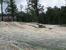
On the day of 9/21/09, the biggest flood in Georgia's history impacted Villa Rica. It caused nearly 500 million dollars in damage to the state.[24] This event caused damage to water lines and infrastructure, causing many of the residents to go without water for nearly a week.
Arts, entertainment, festivals
- Thomas A. Dorsey Festival, closest Saturday to July 1, features gospel music and blues
- Gold Rush Festival, Saturday after Labor Day
- Homecoming parade and pep rally (2006's theme was Disco Fever, following 2005's theme Are you Ready to Luau?)
- The movie Randy and the Mob was filmed mostly in Villa Rica in August 2005
Education
Public education in Villa Rica is handled by the Carroll County School District (Georgia) and the Douglas County School District. [25]
Public schools include:
- Glanton-Hindsman Elementary School [26]
- Ithica Elementary School [27]
- Villa Rica Elementary School [28]
- Mirror Lake Elementary School [29]
- Bay Springs Middle School [30]
- Villa Rica Middle School [31]
- Villa Rica High School [32]
Private schools include:
Demographics
| Historical population | |||
|---|---|---|---|
| Census | Pop. | %± | |
| 1880 | 212 | — | |
| 1890 | 426 | 100.9% | |
| 1900 | 576 | 35.2% | |
| 1910 | 855 | 48.4% | |
| 1920 | 1,047 | 22.5% | |
| 1930 | 1,304 | 24.5% | |
| 1940 | 1,522 | 16.7% | |
| 1950 | 1,703 | 11.9% | |
| 1960 | 3,450 | 102.6% | |
| 1970 | 3,922 | 13.7% | |
| 1980 | 3,420 | −12.8% | |
| 1990 | 6,542 | 91.3% | |
| 2000 | 4,134 | −36.8% | |
| 2010 | 13,956 | 237.6% | |
| Est. 2015 | 14,904 | [35] | 6.8% |
2000 census
As of the census[1] of 2000, there were 4,134 people, 1,550 households, and 1,114 families residing in the city. The population density was 329.2 people per square mile (127.1/km²). There were 1,769 housing units at an average density of 140.9 per square mile (54.4/km²). The racial makeup of the city was 79.32% White, 17.90% African American, 0.80% Native American, 0.27% Asian, 0.02% Pacific Islander, 1.06% from other races, and 0.63% from two or more races. Hispanic or Latino of any race were 2.18% of the population.
There were 1,550 households out of which 35.4% had children under the age of 18 living with them, 49.9% were married couples living together, 17.9% had a female householder with no husband present, and 28.1% were non-families. 22.8% of all households were made up of individuals and 10.8% had someone living alone who was 65 years of age or older. The average household size was 2.67 and the average family size was 3.14.
In the city the population was spread out with 28.0% under the age of 18, 9.9% from 18 to 24, 31.1% from 25 to 44, 20.1% from 45 to 64, and 10.9% who were 65 years of age or older. The median age was 32 years. For every 100 females there were 93.7 males. For every 100 females age 18 and over, there were 86.5 males.
The median income for a household in the city was $31,161, and the median income for a family was $37,138. Males had a median income of $31,103 versus $21,516 for females. The per capita income for the city was $14,310. About 11.4% of families and 13.1% of the population were below the poverty line, including 11.1% of those under age 18 and 29.6% of those age 65 or over.

The growth boom
Over most of its 180-year history, Villa Rica was a small rural railroad and factory town with a fairly stable population of around 4,000 people. This is in spite of the fact that it is located only half an hour from downtown Atlanta. However, throughout the 1990s, a 2,000-acre (8.1 km2) tract of land surrounding a 210-acre (0.85 km2) lake known as both Val-Da-Mar Lake and Stockmar Lake got a lot of interest from developers. One group proposed the creation of a Gone with the Wind theme park,[37] while others considered more standard ideas such as building homes and businesses.
What finally occurred was the creation of a subdivision named Mirror Lake which supplied the oft-named lake with a third name. At the time the subdivision was proposed, Villa Rica had approximately 1,500 homes. The Mirror Lake subdivision added over 2,000 homes in its original proposal, and subsequent changes and additions have increased that number so that there will be almost 3,000 residences by the time the project is fully completed.
The substantial investment in Mirror Lake inspired other developers to begin proposing other projects around Villa Rica. Though the other developments were on a much smaller scale, all of the other building projects combined almost matched the Mirror Lake project in total number of residences. Before the economic recession forced the cancelation or postponement of many projects, Villa Rica's population projections were as follows:
| Population projections for Villa Rica, GA | ||||||
| (in April of the given year) | ||||||
| Year | Population | Change | Year | Population | Change | |
|---|---|---|---|---|---|---|
| 2001 | 5,511 | 30% | 2006 | 11,490 | 12% | |
| 2002 | 6,985 | 23% | 2007 | 12,716 | 11% | |
| 2003 | 7,812 | 19% | 2008 | 13,942 | 10% | |
| 2004 | 9,038 | 16% | 2009 | 15,168 | 9% | |
| 2005 | 10,264 | 14% | 2010 | 16,394 | 8% | |
| Source: Villa Rica Draft Comprehensive Plan[38] | ||||||
The 2025 population projection was estimated to be 34,784.[38] However, as noted above, the 2010 census showed Villa Rica's actual population to be less than projected.
Notable people
Rod Man - winner of Last Comic Standing
- Asa Griggs Candler, Coca-Cola business executive and mayor of Atlanta
- Warren Akin Candler, bishop of the Methodist Episcopal Church, South, and tenth president of Emory University
- Jae Crowder, professional basketball player
- Thomas A. Dorsey, early innovator of black gospel music
- Audrey Middleton, Big Brother's first transgender contestant
- Maidie Norman, actress
- Dixie Walker, professional baseball player
- Herman "Thunderfoot" Weaver, professional football player
References
- 1 2 "American FactFinder". United States Census Bureau. Archived from the original on September 11, 2013. Retrieved 2008-01-31.
- ↑ "US Board on Geographic Names". United States Geological Survey. 2007-10-25. Retrieved 2008-01-31.
- 1 2 "Geographic Identifiers: 2010 Demographic Profile Data (G001): Villa Rica city, Georgia". U.S. Census Bureau, American Factfinder. Retrieved July 18, 2014.
- ↑ "US Gazetteer files: 2010, 2000, and 1990". United States Census Bureau. 2011-02-12. Retrieved 2011-04-23.
- 1 2 "MONTHLY AVERAGES for Villa Rica, Georgia". The Weather Channel Interactive, Inc. Retrieved 2007-12-14.
- 1 2 "Villa Rica Draft Comprehensive Plan" (PDF). Georgia Department of Community Affairs. Retrieved 2007-12-14.
- ↑ "Villa Rica Brochure". Retrieved 2007-05-31.
- 1 2 3 4 Mary Talley Anderson (1976), The History of Villa Rica (City of Gold), privately published.
- ↑ Program, 50th Anniversary Remembrance Ceremony, December 5, 2007, Villa Rica Historic Preservation Committee.
- ↑ Blevins, Ernest Everett, "Bankhead Highway Cuts Though Villa Rica," The Villa Rican, Vol. 73, No. 27 (10 July 2008), 10.; Blevins, Ernest Everett, "Villa Rica Section of Interstate I-20 Celebrates 30 Years," The Villa Rican, Vol. 73, No. 1 (10 January 2008), 1.
- ↑ Determined by the well documented date of the bus firebombing and Atlanta newspaper accounts of the arrival and departure. With Bankhead Highway/U.S. 78 the main east-west route it was determined when the Freedom Riders passed though and stopped at the bus station then located on the first block of South Carroll Road. -- Ernest Everett Blevins
- ↑ "Georgia Tourism - Wick's Tavern". Georgia Department of Economic Development. Retrieved 2007-12-14.
- ↑ "Historic Sites". Villa Rica Tourism Bureau. Retrieved 2007-12-14.
- 1 2 "Pine Mountain Gold Museum at Stockmar Park". The City of Villa Rica. Retrieved 23 October 2012.
- 1 2 "National Register of Historic Places". Retrieved 23 October 2012.
- ↑ Georgia Laws 1916 and 1956
- ↑ "Church History". Mt. Prospect Baptist Church. Retrieved 2007-12-16.
- ↑ "A Brief History of our Church". First Presbyterian Church of Villa Rica. Retrieved 2007-12-16.
- ↑ "History of the Villa Rica Methodist Church". First United Methodist Church of Villa Rica. Retrieved 2007-12-16.
- ↑ "GEORGIA - Carroll County". National Register of Historical Places. Retrieved 2007-12-16.
- ↑ "Carroll County Community Greenspace Program" (PDF). Carroll County, Georgia. Retrieved 2007-12-16.
- ↑ "Williams-Mitchell Farm Documentation and Interpretive Plan". Center for Public History, University of West Georgia. Retrieved 2007-12-16.
- ↑ Blevins, Ernest Everett, MFA "'Old Library' a Piece of Villa Rica's History", The Villa Rican, Vol. 72. No. 31 (3 August 2006), 5 Spencer Crawford, "At Least One Still Works to Save Old Building," The Villa Rican, Vol. 72, No. 25 (21 June 2007) 1, 6. Spencer Crawford, "Survey Claims No Need for More Parking," The Villa Rican, Vol 72, No. 2 (11 January 2007), 1, 3. Spencer Crawford, "Should Old Downtown Building Be Saved?" The Villa Rican, Vol. 72, No. 48 (30 November 2006), 1-2. Tony Montcalm, "Downtown Parking Survey Underway," The Villa Rican, Vol. 72, No. 34 (25 August 2005) 1, 11. Tony Montcalm, "Villa Rica Man Fights to Save Old Library," The Villa Rican, Vol. 72, No. 22 (2 June 2005), 1-2. "Villa Rica Old Library" http://www.city-data.com/picfilesc/picc34718.php "Villa Rica Old Library Update," http://moderngeorgia.wordpress.com/2006/04/19/villa-rica-library/ "Villa Rica, Georgia" http://www.openencyclopedia.net/index.php/Villa_Rica%2C_Georgia
- ↑ Georgia, Howard Perlman, USGS South Atlantic Water Science Center -. "USGS South Atlantic Water Science Center - Georgia: September 2009 Flooding Information and Data". ga.water.usgs.gov. Retrieved 2016-09-29.
- ↑ Carroll County School District
- ↑ Glanton-Hindsman Elementary School
- ↑ Ithica Elementary School
- ↑ Villa Rica Elementary School
- ↑ Mirror Lake Elementary School
- ↑ Bay Springs Middle School
- ↑ Villa Rica Middle School
- ↑ Villa Rica High School
- ↑ Sunbrook Academy at Bay Springs
- ↑ Mirror Lake Academy
- ↑ "Annual Estimates of the Resident Population for Incorporated Places: April 1, 2010 to July 1, 2015". Retrieved July 2, 2016.
- ↑ "Census of Population and Housing". Census.gov. Archived from the original on May 11, 2015. Retrieved June 4, 2015.
- ↑ "Gone With the Licensing Agreement". The New York Times. 1996-12-15. Retrieved 2007-12-17.
- 1 2 "Villa Rica Draft Comprehensive Plan" (PDF). Georgia Department of Community Affairs. Retrieved 2007-12-17.
Further reading
- Mary Talley Anderson. The History of Villa Rica (City of Gold). Privately printed, 1976.
External links
- City of Villa Rica official website
- Villa Rica News
- Villa Rica tourism website
- Pine Mountain Gold Museum
- Villa Rica profile on Georgia.gov
Municipalities and communities of Carroll County, Georgia, United States | ||
|---|---|---|
| Cities |  | |
| Towns | ||
| Unincorporated community | ||
| Footnotes | ‡This populated place also has portions in an adjacent county or counties | |
Municipalities and communities of Douglas County, Georgia, United States | ||
|---|---|---|
| Cities |  | |
| CDP | ||
| Unincorporated communities | ||
| Footnotes | ‡This populated place also has portions in an adjacent county or counties | |