Wakkanai, Hokkaido
| Wakkanai 稚内市 | |||
|---|---|---|---|
| City | |||
|
View of Wakkanai from Wakkanai Park | |||
| |||
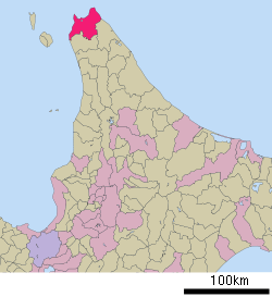 Location of Wakkanai in Hokkaido Prefecture, highlighted in pink | |||
 Wakkanai
| |||
| Coordinates: 45°24′56.4″N 141°40′23″E / 45.415667°N 141.67306°ECoordinates: 45°24′56.4″N 141°40′23″E / 45.415667°N 141.67306°E | |||
| Country | Japan | ||
| Region | Hokkaido | ||
| Prefecture | Hokkaido | ||
| Government | |||
| • Mayor | Hiroshi Kudo (since May 2011) | ||
| Area | |||
| • Total | 760.80 km2 (293.75 sq mi) | ||
| Population (October 2013) | |||
| • Total | 37,011 | ||
| • Density | 48.65/km2 (126.0/sq mi) | ||
| Time zone | Japan Standard Time (UTC+9) | ||
| - Tree | Sakura, rowan | ||
| - Flower | Rosa rugosa | ||
| Phone number | 0162-23-6161 | ||
| Address | 3-13-15 Chūō, Wakkanai-shi, Hokkaido 097-8686 | ||
| Website |
www | ||


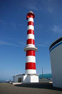
Wakkanai (稚内市 Wakkanai-shi, Ainu: ヤㇺワッカナイ Yam-wakka-nay meaning 'cold water river'[1]) is a city located in Sōya Subprefecture, Hokkaido, Japan. It is the capital of Sōya Subprefecture and the northernmost city in Japan. It contains Japan's northernmost point, Cape Soya, from which the Russian island of Sakhalin can be seen.
As of October 2013, the city has an estimated population of 37,011 and a population density of 48.65 persons per km² (126 persons per mi²). The total area is 760.80 km2 (293.75 sq mi).[2][3]
History
Wakkanai was originally home to an Ainu population. The first Japanese settlement was established in 1685.[4]
- 1879 The village of Wakkanai was founded.
- 1897 Sōya Subprefecture established.
- 1901 Wakkanai village became Wakkanai town.
- 1949 Wakkanai town became Wakkanai city.
- 1955 Soya village was merged into Wakkanai city.
- 1959 Wakkanai Airport opened.
During WW II: The Imperial Japanese Navy used the harbor and port as a submarine base. Wakkanai, was far enough north to be out of the range of American heavy bombers and was safe from air attack. Until the early-mid 60’s, the northern portion of the harbor remained divided by concrete sub-mooring pens. The large breakwater structure (which still exists) was actually a sub-repair facility. At the shore end there was a huge winching mechanism capable of hauling subs up into the partially enclosed structure where they could be worked on while completely out of the water. Built into the hills above the city there were several reinforced concrete bunker-type caves where (anecdotally) they were used either to store ammunition and armament, or as air raid shelters for the civilian populace. History would suggest the former use, rather than the latter. During a re-build/renovation of the harbor sometime during the 60’s or 70’s the harbor was cleared of the concrete pens and the machinery was removed from the breakwater structure which was reconfigured.
Geography
Cape Soya is located near Wakkanai, which is on a peninsula jutting towards Sakhalin. There is Benten-jima by northwest of Cape Soya.
- Rivers: Koetoi River
- Lakes: Ōnuma
Surrounding municipalities
Climate
Wakkanai has the typical humid continental climate (Köppen Dfb) of Hokkaido, with cold winters, warm summers and generally heavy precipitation from the Aleutian Low, whose winds hit the city direct from the Sea of Japan. The mean annual temperature, at 6.8 °C (44.2 °F), is the second lowest for a significant population centre in Japan after Nemuro. Snowfall at 6.6 metres (260 in), the third highest for a big city in Japan after Asahikawa and Aomori and one of the highest anywhere in the world. For comparison, Nain in Canada receives 194 inches (4.9 m) of snow.
The Aleutian Low also makes the sunshine hours the lowest of Japan’s major population centres and in the winter the wind speeds are the highest in Japan with an average of 20.2 km/h (12.6 mph), which adds to the −4.7 °C (23.5 °F) cold of a typical winter day. The city's port is usually usable throughout the year, but does occasionally freeze in cold winters.
| Climate data for Wakkanai (1981–2010) | |||||||||||||
|---|---|---|---|---|---|---|---|---|---|---|---|---|---|
| Month | Jan | Feb | Mar | Apr | May | Jun | Jul | Aug | Sep | Oct | Nov | Dec | Year |
| Average high °C (°F) | −2.7 (27.1) |
−2.5 (27.5) |
1.2 (34.2) |
7.2 (45) |
12.0 (53.6) |
15.7 (60.3) |
19.7 (67.5) |
22.3 (72.1) |
19.7 (67.5) |
13.7 (56.7) |
6.1 (43) |
0.1 (32.2) |
9.4 (48.9) |
| Daily mean °C (°F) | −4.7 (23.5) |
−4.7 (23.5) |
−1.0 (30.2) |
4.4 (39.9) |
8.8 (47.8) |
12.7 (54.9) |
16.8 (62.2) |
19.6 (67.3) |
16.8 (62.2) |
11.1 (52) |
3.6 (38.5) |
−2.0 (28.4) |
6.8 (44.2) |
| Average low °C (°F) | −6.8 (19.8) |
−7.1 (19.2) |
−3.5 (25.7) |
1.8 (35.2) |
6.0 (42.8) |
10.1 (50.2) |
14.5 (58.1) |
17.3 (63.1) |
14.0 (57.2) |
8.1 (46.6) |
1.0 (33.8) |
−4.2 (24.4) |
4.3 (39.7) |
| Average precipitation mm (inches) | 84.3 (3.319) |
60.7 (2.39) |
50.3 (1.98) |
49.0 (1.929) |
67.6 (2.661) |
53.0 (2.087) |
90.6 (3.567) |
116.0 (4.567) |
123.5 (4.862) |
134.1 (5.28) |
120.9 (4.76) |
112.8 (4.441) |
1,062.8 (41.843) |
| Average snowfall cm (inches) | 173 (68.1) |
143 (56.3) |
102 (40.2) |
21 (8.3) |
0 (0) |
0 (0) |
0 (0) |
0 (0) |
0 (0) |
1 (0.4) |
53 (20.9) |
160 (63) |
653 (257.2) |
| Average snowy days | 26.2 | 24.2 | 9.2 | 1.2 | 0 | 0 | 0 | 0 | 0 | 3.4 | 17.7 | 28.2 | 110.1 |
| Average relative humidity (%) | 72 | 72 | 71 | 75 | 79 | 85 | 86 | 84 | 75 | 68 | 67 | 70 | 75.3 |
| Mean monthly sunshine hours | 45.6 | 80.3 | 138.6 | 171.8 | 185.6 | 166.3 | 146.8 | 148.5 | 177.1 | 135.9 | 57.6 | 30.1 | 1,484.2 |
| Source: Japan Meteorological Agency | |||||||||||||
Transportation
Air
Wakkanai Airport is located in Wakkanai.
Rail
JR Hokkaido runs a diesel train service on the Sōya Main Line from Asahikawa to Sapporo.
- Sōya Main Line : Yūchi - Bakkai - Minami-Wakkanai - Wakkanai
Sea
Heartland Ferry operates seasonal ferry service to Rebun-to and Rishiri-to. Ferry service to Korsakov on Sakhalin Island was terminated on September 18, 2015. Wakkanai governor KUDO Hiroshi has pledged to restore ferry service to Sakhalin, using city funds if necessary.
For the 2016 summer season, this route will be serviced by a high-speed catamaran ferry from Singapore named Penguin 33. The ferry is owned by Penguin International Limited and operated by Sakhalin Shipping Company.
Education
University
- Wakkanai Hokusei Gakuen University
High schools
Public
- Hokkaido Wakkanai High School
Private
- Wakkanai Otani High School
Tourist attractions

The Daisuke Matsuzaka Museum, dedicated to the baseball pitcher "Dice-K" and opened in 2008, is located in Wakkanai, which is his father's hometown.[5]
Sister cities and friendship cities
Sister city
Friendship cities
Domestic
-
 Ishigaki, Okinawa (since 1987)[7]
 - Makurazaki, Kagoshima (since 2012)
International
-
 Nevelsk, Russia (since 1972)
 - Korsakov, Russia (since 1992)
- Yuzhno-Sakhalinsk, Russia (since 2001)
Sister ports
-
 Port of Anchorage, United States (since 1982)
References
- ↑ アイヌ語地名リスト [Ainu Language Place Name List] (PDF) (in Japanese). Office of Ainu Measures Promotion, Department of Environment and Lifestyle, Hokkaido Government. Retrieved January 29, 2015.
- ↑ 稚内市の概要 [Outline of Wakkanai] (in Japanese). Wakkanai, Hokkaido Prefecture, Japan: City of Wakkanai. 2013. Retrieved 2013-11-09.
- ↑ 稚内市の人口と世帯 [Population and Households of Wakkanai] (in Japanese). Wakkanai, Hokkaido Prefecture, Japan: City of Wakkanai. 2013. Retrieved 2013-11-09.
- ↑ History of Wakkanai
- ↑ ESPN.com article
- ↑ International interaction of Wakkanai
- ↑ Domestic Interaction of Wakkanai
External links
-
 Wakkanai travel guide from Wikivoyage
 -
 Media related to Wakkanai, Hokkaido at Wikimedia Commons
 - Official website (Japanese)