Wandoan
| Wandoan Queensland | |||||||||||||
|---|---|---|---|---|---|---|---|---|---|---|---|---|---|
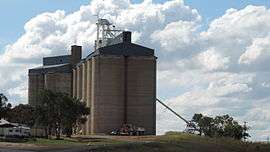 Grain silos in 2014 | |||||||||||||
 Wandoan | |||||||||||||
| Coordinates | 26°8′S 149°57′E / 26.133°S 149.950°ECoordinates: 26°8′S 149°57′E / 26.133°S 149.950°E | ||||||||||||
| Population | 665 (2011 census)[1] | ||||||||||||
| Postcode(s) | 4419 | ||||||||||||
| Location | |||||||||||||
| LGA(s) | Western Downs Region | ||||||||||||
| State electorate(s) | Callide | ||||||||||||
| Federal Division(s) | Flynn | ||||||||||||
| |||||||||||||
Wandoan /ˈwɒndoʊ.ən/ is a town and locality in the Western Downs Region, Queensland, Australia.[2][3] It was formerly known as Juandah. It is on the Leichhardt Highway about halfway between Taroom and Miles and is the centre for the local cattle industry. At the 2011 census, Wandoan had a population of 665.[1]
History
The beginnings of the Wandoan township can be traced back to 1853 when 'Juandah' Station was established at this location in 1849. When Herbert Salway and Percival Sydney Francis Stephen first tendered for a huge area of land: Juandah of 23,000 acres (9,300 ha) and two other runs Coringa of 21,000 acres (8,500 ha) and Cherwondah of 19,200 acres (7,800 ha). This area, defined in accordance with the 1847 Orders-in-Council, falls far short of the actual size of the holding, which has been estimated at 449 square miles (1,160 km2)—five and a half times as much. The aggregation of these three runs became known as Juandah and records show Percival Stephen was living on Juandah before August 1849. A wayside hotel was built there in the 1890s, and by the end of the nineteenth century the hotel was well established and a township was formed.
The railway to Miles opened on 16 December 1914.
Juandah was named Wandoan in 1926 to avoid confusion with Jundah near Longreach.
After World War II, land around Wandoan was used for soldier settlements through ballots in the 1950s.[4]
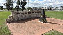
The Wandoan War Memorial is in front of the Community Culture Centre on Henderson Street and commemorates Australians who served in all wars. There are plaques for individual wars on the wall behind the memorial. The monument was dedicated on 25 April (Anzac Day) 1993.[5][6]
Economy
The town's economy is traditionally based on agriculture, including wheat, sorgum and cattle. The townscale is visually dominated by the grain silos near the railway station. However, mining for coal and gas are growing industries, increasing the population and facilities in Wandoan.[4]
Tourism
The following are features of interest in Wandoan:[7]
- the local Heritage Trail leads to 23 points of interest, including the Juandah site and the Waterloo Plains Environmental Park with its lakes, picnic areas and water birds
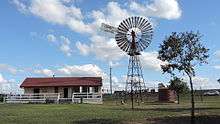
- the 'Wandoan Windmill' at the town entrance on the Highway across from a colourful mural painted on the town's main water tank.
- a mural depicting local history in the Community Cultural Centre on a huge piece of local sandstone.
- the Wandoan Races: horse racing meetings held once or twice every year.
- Wandoan Unlicensed Airport is 1.2 kilometres (0.75 mi) away.
The Wandoan Information Centre on Royd Street provides information for visitors. It is housed in a former railway station building and is easily spotted by the large windmill beside it.[8]
School
Juandah Provisional School opened on 30 October 1911. It became a State School on 1 March 1915 and was renamed Wandoan State School in 1924.[9][10]
Amenities
Wandoan Community Cultural Centre is located on Henderson Road (26°07′16″S 149°57′31″E / 26.12106°S 149.95870°E). It is operated by the Western Downs Regional Council and offer a library and a public hall used for meetings and entertainment.[11][12]
Services
Wandoan has the following services:[13]
- Ambulance service, doctor, out-patients clinic, veterinary surgeon
- Fire brigade, police station
- tank water, town water, TV reception – v.a.s.t only, normal alternating current (ac) power
- Railway station (closed, no longer used), coach bus service (three services per week), full vehicle service
- Chemist, hotel/motel, official post office, mail collected daily
Climate
The temperature varies between 21 °C (70 °F) – 34 °C (93 °F) in summer and 5 °C (41 °F) – 22 °C (72 °F) in winter.[14]
Population
| Year | Population | Notes |
|---|---|---|
| 2001 | 401 | [15] |
| 2006 | 386 | [16] |
| 2011 | 655 | [1] |
Notable people
- Darren Lockyer, Australia, Queensland and Brisbane rugby league captain grew up in Wandoan.[17]
References
- 1 2 3 Australian Bureau of Statistics (31 October 2012). "Wandoan (SSC)". 2011 Census QuickStats. Retrieved 15 May 2014.
- ↑ "Wandoan (town) (entry 36427)". Queensland Place Names. Queensland Government. Retrieved 15 May 2014.
- ↑ "Wandoan (locality) (entry 47754)". Queensland Place Names. Queensland Government. Retrieved 15 May 2014.
- 1 2 "Wandoan and District". Western Downs Regional Council. Retrieved 16 May 2014.
- ↑ "Wandoan War Memorial". Monument Australia. Retrieved 16 May 2014.
- ↑ "Wandoan War Memorial". Queensland Government. Retrieved 16 May 2014.
- ↑ Tourism Queensland (2006). "Wandoan – Places to visit". Queensland holidays. Retrieved 20 February 2007.
- ↑ "Wandoan, Qld". Highway Traveller. Retrieved 16 May 2014.
- ↑ The State of Queensland (Department of Public Works) (2006). "Wandoan State School". Queensland State Archives. Archived from the original on 12 February 2011. Retrieved 20 February 2007.
- ↑ "STATE SCHOOLS.". The Brisbane Courier. National Library of Australia. 5 March 1915. p. 4. Retrieved 16 May 2014.
- ↑ "About Us". Western Downs Libraries. Western Downs Regional Council. Retrieved 16 May 2014.
- ↑ "Wandoan". The Age. 8 February 2004. Archived from the original on 16 May 2014. Retrieved 16 May 2014.
- ↑ The State of Queensland (Department of Education) (2007). "Schools Directory – Business Centre – Services". Queensland Government Department of Education, Training and the Arts. Archived from the original on 12 February 2011. Retrieved 20 February 2007.
- ↑ Tourism Queensland (2006). "Wandoan Climate". Queensland holidays. Archived from the original on 12 February 2011. Retrieved 20 February 2007.
- ↑ Australian Bureau of Statistics (9 March 2006). "Wandoan (L)". 2001 Census QuickStats. Retrieved 15 May 2014.
- ↑ Australian Bureau of Statistics (25 October 2007). "Wandoan (L)". 2006 Census QuickStats. Retrieved 15 May 2014.
- ↑ Koch, Dan (11 May 2010). "Darren Lockyer". Alpha. Australia: News Magazines. Retrieved 13 July 2010.
External links
![]() Media related to Wandoan, Queensland at Wikimedia Commons
Media related to Wandoan, Queensland at Wikimedia Commons