Warra, Queensland
| Warra Queensland | |
|---|---|
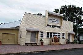 Warra Memorial Hall | |
 Warra | |
| Coordinates | 26°55′S 150°57′E / 26.917°S 150.950°ECoordinates: 26°55′S 150°57′E / 26.917°S 150.950°E |
| Population | 84 (2006 census)[1] |
| Postcode(s) | 4411 |
| Location |
|
| LGA(s) | Western Downs Region |
| State electorate(s) | Darling Downs |
| Federal Division(s) | Maranoa |
Warra is a town in the Darling Downs region of Queensland, Australia. It is in the Western Downs Region local government area and on the Warrego Highway, 256 kilometres (159 mi) north west of the state capital, Brisbane. At the 2006 census, Warra had a population of 84.[1]
History
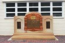
Warra War Memorial, 2008
The Warra Honour Board was unveiled on 14 May 1917 by Member of the Queensland Legislative Assembly in Dalby, William Vowles.[2]
Miscellaneous
The name Warra has been used as a name for a crater on the planet Mars, without specifically commemorating the town.[3]
References
http://planetarynames.wr.usgs.gov/Feature/6490?__fsk=356925047
| Wikimedia Commons has media related to Warra, Queensland. |
- 1 2 Australian Bureau of Statistics (25 October 2007). "Warra (Wambo Shire) (State Suburb)". 2006 Census QuickStats. Retrieved 2009-03-31.
- ↑ "Warra War Memorial". Monument Australia. Retrieved 3 April 2014.
- ↑ Categories for Naming Features on Planets and Satellites, Gazetteer of Planetary Nomenclature, USGS Astrogeology Science Center, NASA
External links
This article is issued from Wikipedia - version of the 7/18/2016. The text is available under the Creative Commons Attribution/Share Alike but additional terms may apply for the media files.