Wallangarra, Queensland
| Wallangarra Queensland | |||||||||||||
|---|---|---|---|---|---|---|---|---|---|---|---|---|---|
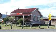
.JPG) Border "gates" at Wallangarra | |||||||||||||
 Wallangarra | |||||||||||||
| Coordinates | 28°54′0″S 151°56′0″E / 28.90000°S 151.93333°ECoordinates: 28°54′0″S 151°56′0″E / 28.90000°S 151.93333°E | ||||||||||||
| Population | 385 (2006 census)[1] | ||||||||||||
| Established | 1885 | ||||||||||||
| Postcode(s) | 4383 | ||||||||||||
| Location |
| ||||||||||||
| LGA(s) | Southern Downs Region | ||||||||||||
| County | Bentinck | ||||||||||||
| Parish | Tenterfield | ||||||||||||
| State electorate(s) | Southern Downs | ||||||||||||
| Federal Division(s) | Maranoa | ||||||||||||
| |||||||||||||
Wallangarra is a town and locality in the Southern Downs Region, Queensland, Australia.[2][3] It is the third most southerly town in Queensland, 258 kilometres (160 mi) south west of Brisbane. Wallangarra is on the Queensland side of the border and Jennings is on the New South Wales side. At the 2006 census, Wallangarra had a population of 385.[1]
In 1885, the Queensland government announced that a town would be formed where the railway line between Queensland and New South Wales would meet. On 29 June 1885, 179 lots were offered for sale at £8 per acre (£20/ha).[4]
Geography
Wallangarra lies in a valley between two ranges of mountains, which each are branches of the Great Dividing Range. It is 878 m above sea level. There is a gap between the more Westerly range at Wyberba, about five kilometres north of Wallangarra. This gap has made Wallangarra the major inland border crossing for the New England Highway and what was the first railway line between Brisbane and Sydney.
Climate
Wallangarra is one of the coldest towns in Queensland, due to its altitude and extreme southerly location in the state. Maximum temperatures rarely rise above 15 °C (59 °F) in winter or above 30 °C (86 °F) in summer. Wallangarra holds the record for the lowest maximum temperature in Queensland, 2.4 °C (36 °F) on 3 July 1984.[5] Despite this, minimum temperatures are not as low due to local geographic variations, and towns well to the north such as Warwick and Oakey frequently record lower minimums.
| Climate data for Wallangarra Post Office | |||||||||||||
|---|---|---|---|---|---|---|---|---|---|---|---|---|---|
| Month | Jan | Feb | Mar | Apr | May | Jun | Jul | Aug | Sep | Oct | Nov | Dec | Year |
| Record high °C (°F) | 36.2 (97.2) |
34.3 (93.7) |
31.7 (89.1) |
34.5 (94.1) |
24.5 (76.1) |
20.7 (69.3) |
20.4 (68.7) |
25.9 (78.6) |
28.1 (82.6) |
32.6 (90.7) |
35.0 (95) |
36.0 (96.8) |
36.2 (97.2) |
| Average high °C (°F) | 26.6 (79.9) |
25.4 (77.7) |
24.1 (75.4) |
21.1 (70) |
17.5 (63.5) |
14.5 (58.1) |
13.9 (57) |
15.3 (59.5) |
18.4 (65.1) |
21.5 (70.7) |
24.3 (75.7) |
26.6 (79.9) |
20.8 (69.4) |
| Average low °C (°F) | 14.7 (58.5) |
14.7 (58.5) |
13.1 (55.6) |
9.3 (48.7) |
5.7 (42.3) |
3.0 (37.4) |
2.0 (35.6) |
2.7 (36.9) |
5.2 (41.4) |
8.3 (46.9) |
11.0 (51.8) |
13.3 (55.9) |
8.6 (47.5) |
| Record low °C (°F) | 7.7 (45.9) |
6.1 (43) |
3.0 (37.4) |
−1.5 (29.3) |
−3.7 (25.3) |
−5.6 (21.9) |
−5.1 (22.8) |
−4.5 (23.9) |
−3.7 (25.3) |
−2.7 (27.1) |
1.7 (35.1) |
5.4 (41.7) |
−5.6 (21.9) |
| Average rainfall mm (inches) | 101.7 (4.004) |
85.4 (3.362) |
68.2 (2.685) |
38.2 (1.504) |
44.7 (1.76) |
47.5 (1.87) |
50.4 (1.984) |
40.6 (1.598) |
47.8 (1.882) |
75.6 (2.976) |
81.1 (3.193) |
99.8 (3.929) |
781 (30.747) |
| Average rainy days (≥ 0.2mm) | 9.3 | 8.8 | 8.0 | 6.1 | 6.6 | 6.9 | 6.8 | 6.3 | 6.4 | 8.0 | 8.7 | 9.6 | 91.5 |
| Source: Bureau of Meteorology[5] | |||||||||||||
A railway heritage
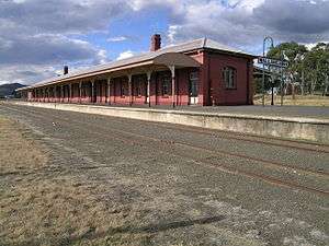
The town was created to service a break-of-gauge between Queensland's narrow gauge Southern railway line of 3 ft 6 in (1,067 mm) and New South Wales's standard gauge Main North railway line of 4 ft 8 1⁄2 in (1,435 mm) when the two systems came together in 1888.[6] The railway was the only rail link between Queensland and New South Wales until a standard gauge track was completed in 1932, with the completion of the bridge at Grafton. From that time on, the Wallangarra station lessened in importance. All scheduled rail services stopped in 1997.[7] In 2003, after major refurbishment, the station was reopened as a museum.
The railway line from Stanthorpe to Wallangarra has continued to be maintained and steam trains taking tourists to Wallangarra occasionally operate.
Despite being declared as Wallangarra, the station itself has the Queensland name boards hyphenated as Wallan-Garra.[8]
| Preceding station | NSW Main lines | Following station | ||
|---|---|---|---|---|
| Terminus | Main North Line | towards Sydney |
Heritage listings
Wallangarra has a number of heritage-listed sites, including:
- Woodlawn Street: Wallangarra station[9]
Army stores depot
During World War II, the Commonwealth Government created a general army store on the Queensland side of the border, and an ammunition dump on the New South Wales side. Dual gauge tracks were run to each store.
Access to the army stores was via Margetts St, one of the main roads in the town. The late Muriel Daphne Verdun Nicolson lived at 30 Margetts St from before WWII until her death in 2001. During WWII she reported that the flow of trucks and materiel went on all day and night.
As of 2013, the Wallangarra Stores Depot remained a major Australian Army logistics facility. It is used to store a wide range of engineering and general equipment, clothing, and tents. Bulk fuel storage handling apparatus are also held at the site.[10] The munitions storage facility is also still active in Jennings.[11]
Riverina Stock Feeds
Taking advantage of the rail junction Riverina Stock Feeds operated a packing plant opposite the Wallangarra railway station for many years until 1995. After that it moved to Warwick, a city 100 kilometres (62 mi) to the north. Warwick also has a major Woolworths warehouse. Interestingly the Chairman of Woolworths who located the warehouse at Warwick grew up in Wallangarra.
Abattoirs
Until 1982 The Anderson Meat Packing Company operated a large beef abattoir at Wallangarra. Anderson's employed in excess of 400 workers at the Wallanagarra plant. The plant was located on the border so as to take advantage of rail lines from both Queensland and NSW.
After this closed the town's future looked dim. Ten years later, however, Australia's largest mutton works opened on a new site just to the east of the town. The mutton produced is Halal, and most of it is exported to Arab countries.
Wallangarra Dam
Drive out along Margetts St, over the railway bridge, past the Rugby League grounds and out past the army. From there follow Old Paling Yard Road up the foot hills of Mt Norman. There you will find a water treatment plant and a road branch to the left going down to Beehive dam. Beehive dam is in the mountains, and fed by a spring. It is a beautiful place for a picnic.
Attractions
Wallangarra is situated on the picturesque Granite Belt, and is bounded by Sundown National Park to the West and Girraween National Park to the East. Being situated on the Great Dividing Range, Sundown is dry and Girraween is much more moist.
Facilities

The Wallangarra cemetery is in McCall Street.
Notable former residents
Rugby League legend Billy Moore lived in Wallangarra as a child. He is best known for playing for the North Sydney Bears and the Queensland State of Origin team. He was born in Tenterfield, New South Wales as this was the closest hospital.[12]
References
- 1 2 Australian Bureau of Statistics (25 October 2007). "Wallangarra (L) (Urban Centre/Locality)". 2006 Census QuickStats. Retrieved 25 July 2009.
- ↑ "Wallangarra (entry 363145)". Queensland Place Names. Queensland Government. Retrieved 7 June 2015.
- ↑ "Wallangarra (entry 46000)". Queensland Place Names. Queensland Government. Retrieved 7 June 2015.
- ↑ Stokes, I.M., The History of the Wallangarra Meatworks, The Tenterfield Star, 23 October 1967.
- 1 2 "Wallangarra Post Office". Climate statistics for Australian locations. Bureau of Meteorology. January 2014. Retrieved 13 January 2014.
- ↑ The Centenary of the Southern Line Kerr, J.D. Australian Railway Historical Society Bulletin, December 1970 pp261-291
- ↑ The Last Years of the Warwick/Wallangarra Mails Milne, Rod Australian Railway Historical Society Bulletin, July 1995 pp179-189
- ↑ "Heritage Register". Retrieved 20 September 2014.
- ↑ "Wallangarra Railway Station and Complex (entry 601242)". Queensland Heritage Register. Queensland Heritage Council. Retrieved 13 July 2013.
- ↑ "Wallangarra Stores Depot, Queensland" (PDF). Department of Defence. 1 October 2013. Retrieved 18 July 2015.
- ↑ Australian National Audit Office (2011). "Management of the Explosive Ordnance Services Contract" (PDF). Australian National Audit Office. p. 63. Retrieved 18 July 2015.
- ↑ Sharwood, Anthony (15 June 2011). "Why Queensland care more, and NSW couldn't care less". The Punch. Retrieved 24 August 2011.
External links
| Wikimedia Commons has media related to Wallangarra, Queensland. |