Warwick, Queensland
| Warwick Queensland | |||||||||||||
|---|---|---|---|---|---|---|---|---|---|---|---|---|---|
.jpg) Town Hall | |||||||||||||
 Warwick | |||||||||||||
| Coordinates | 28°13′0″S 152°01′0″E / 28.21667°S 152.01667°ECoordinates: 28°13′0″S 152°01′0″E / 28.21667°S 152.01667°E | ||||||||||||
| Population | 15,505 (2015)[1] | ||||||||||||
| Established | 1850 | ||||||||||||
| Postcode(s) | 4370 | ||||||||||||
| Elevation | 477 m (1,565 ft) | ||||||||||||
| Location |
| ||||||||||||
| LGA(s) | Southern Downs Region | ||||||||||||
| County | Merivale | ||||||||||||
| State electorate(s) | Southern Downs | ||||||||||||
| Federal Division(s) | Maranoa | ||||||||||||
| |||||||||||||
| |||||||||||||
Warwick /ˈwɒrɪk/[2] is a town and locality in southeast Queensland, Australia, lying 130 kilometres (81 mi) south-west of Brisbane.[3][4] It is the administrative centre of the Southern Downs Region local government area. The surrounding Darling Downs have fostered a strong agricultural industry for which Warwick, together with the larger city of Toowoomba, serve as convenient service centres. The town had an estimated urban population of 15,505[1] at June 2015.
Geography
The Condamine River meanders from the east to the north-west of Warwick. One of its tributaries Rosenthal Creek enters Warwick from the south and enters the Condamine within Warwick.[5]
The Cunningham Highway and the New England Highway jointly enter Warwick from the north, cross the Condamine River, and then turn west within the town close to the Warwick central business district. The Cunningham Highway then continues west towards Goondiwindi, while the New England Highway heads south towards Stanthorpe.[5]
The Condamine River often floods which can disconnect the northern and southern parts of Warwick and close the highways. Gauges that measure river height are used to provide flood alerts to residents. Low-lying land around the river is mostly used for recreation to minimise the damage caused by flooding with most developed areas at higher levels. Queens Park is a major park based around the river and the highway crossing.[6]
The Warwick central business district is laid out on a grid pattern and lies within one or two blocks of the long main street, Palmerin Street with Grafton Street the major cross-street. The statue of former Queensland Premier Thomas Byrnes is located at their intersection.[5]
History
The Warwick Green Belt, on the banks of the Condamine River features a sculpture of Tiddalik the mythical frog that drank all of the fresh water in a renowned Aboriginal Dreamtime story.[7]

Patrick Leslie and his two brothers originally settled in the area as squatters, naming their run Canning Downs. In 1847 the NSW government asked Leslie to select a site on his station for a township, which was to be called 'Cannington,' although the name 'Warwick' was eventually settled on. Land sales were held in 1850, and the first allotment was bought by Leslie.[8] The telegraph to Brisbane was operating by 1861. The 1870s were boom years for this new town. In 1871 the railway reached Warwick,[9] a brewery was built in 1873, then a cooperative flour mill and brickworks were completed during 1874.
Warwick was the seat of a series of local government areas, the Borough of Warwick from 1861, Town of Warwick from 1903, City of Warwick from 1936, Shire of Warwick from 1994, and Southern Downs Region from 2008.
On 29 November 1917, the Warwick Incident occurred, which would lead to the formation of the Australian Commonwealth Police with the first commissioner for Commonwealth Police appointed eight days later.[10] As Prime Minister William Morris Hughes was addressing a crowd at the Warwick railway station, a man in the crowd threw an egg dislodging the Prime Minister's hat. Hughes ordered his arrest but the Queensland State policeman present refused to carry out the orders saying that Hughes had no authority over him.
Monuments
A statue of the 12th Queensland Premier Thomas Joseph Byrnes is located on the corner of Palmerin and Grafton Streets.The Thomas Joseph Byrnes Monument was built about 1901.[11]
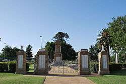
The Warwick War Memorial was built in 1923 and the memorial gates were built in 1924.[12]
Climate
| Climate data for Warwick, Queensland | |||||||||||||
|---|---|---|---|---|---|---|---|---|---|---|---|---|---|
| Month | Jan | Feb | Mar | Apr | May | Jun | Jul | Aug | Sep | Oct | Nov | Dec | Year |
| Record high °C (°F) | 40.9 (105.6) |
38.5 (101.3) |
37.2 (99) |
33.3 (91.9) |
29.7 (85.5) |
26.3 (79.3) |
26.0 (78.8) |
33.0 (91.4) |
35.1 (95.2) |
38.5 (101.3) |
39.8 (103.6) |
40.4 (104.7) |
40.9 (105.6) |
| Average high °C (°F) | 30.1 (86.2) |
29.3 (84.7) |
27.5 (81.5) |
24.9 (76.8) |
21.0 (69.8) |
18.3 (64.9) |
17.9 (64.2) |
20.0 (68) |
23.6 (74.5) |
25.8 (78.4) |
27.6 (81.7) |
29.1 (84.4) |
24.6 (76.3) |
| Average low °C (°F) | 17.0 (62.6) |
17.0 (62.6) |
14.9 (58.8) |
11.3 (52.3) |
6.7 (44.1) |
4.8 (40.6) |
3.1 (37.6) |
3.1 (37.6) |
7.1 (44.8) |
10.4 (50.7) |
13.7 (56.7) |
15.8 (60.4) |
10.4 (50.7) |
| Record low °C (°F) | 9.6 (49.3) |
7.9 (46.2) |
2.9 (37.2) |
−1.8 (28.8) |
−4.7 (23.5) |
−7.0 (19.4) |
−7.7 (18.1) |
−6.3 (20.7) |
−3.8 (25.2) |
0.9 (33.6) |
1.9 (35.4) |
6.5 (43.7) |
−7.7 (18.1) |
| Average precipitation mm (inches) | 82.7 (3.256) |
64.7 (2.547) |
62.6 (2.465) |
31.5 (1.24) |
40.5 (1.594) |
36.8 (1.449) |
27.2 (1.071) |
23.2 (0.913) |
36.0 (1.417) |
73.9 (2.909) |
90.2 (3.551) |
101.9 (4.012) |
670.4 (26.394) |
| Average precipitation days | 8.8 | 8.8 | 8.6 | 7.3 | 7.9 | 9.2 | 7.7 | 5.7 | 6.6 | 8.3 | 10.0 | 10.5 | 99.5 |
| Average relative humidity (%) | 47 | 50 | 47 | 46 | 47 | 50 | 44 | 38 | 36 | 38 | 44 | 43 | 44.2 |
| Mean monthly sunshine hours | 241.8 | 193.2 | 220.1 | 234 | 217 | 183 | 223.2 | 241.8 | 252 | 235.6 | 225 | 241.8 | 2,708.5 |
| Source: Bureau of Meteorology[13] | |||||||||||||
Communications
Newspapers in Warwick include the Warwick Daily News, the Warwick and Southern Downs Weekly and the Southern Free Times. Former newspapers include the Warwick Argus which was published from 1879 to 1919, the Warwick Argus and Tenterfield Chronicle and the Warwick Examiner and Times. Radio station 4WK was established in May 1935.[14] Its coverage was gradually extended to Toowoomba, Pittsworth, Millmerran, Clifton, Allora, Stanthorpe, Crows Nest, Highfields, Dalby, Oakey, Tara, Goondiwindi, Boonah, and Esk. It now broadcasts from Toowoomba.[15]
Notable people
Notable people with a connection to Warwick include
- Francis Andersen, Australian scholar in the fields of biblical studies and Hebrew, born in Warwick
- Wayne Bennett, rugby league player and coach, raised in and played football in Warwick
- Anna Bligh, former Premier of Queensland, born in Warwick
- Lee Bodimeade, hockey player, born in Warwick
- Dean Butler, hockey player, born in Warwick
- Thomas Joseph Byrnes, former Premier of Queensland, Member of the Legislative Assembly for Warwick
- Matt Campbell racing car driver
- Charles Chauvel, filmmaker, born in Warwick
- Cyril Clowes, lieutenant general, born in Warwick
- Patrick Leslie, pioneer settler in Warwick
- Alan Marshall, cricket player, born in Warwick
- Mervyn Meggitt, anthropologist, born in Warwick
- Arthur Morgan, former Premier of Queensland, born in Warwick and Member of the Legislative Assembly for Warwick
- Paul Neville, politician, born in Warwick
- Adrienne Pickering, actress, born in Warwick
- Chris Pickering, musician, born and raised in Warwick
- Russell Skerman, Supreme Court Judge, attended Warwick High School
- Duncan Thompson, Australian rugby league footballer, coach and administrator, born in Warwick
- William Webb, judge, attended school in Warwick
Attractions
- The Pringle Cottage Museum complex operated by the Warwick Historical Society[16]
- Glengallan Homestead [17]
- Warwick Art Gallery [18]
Events
- Warwick Agricultural Show (March) [19]
- FEI Eventing World Cup (May)
- Jumpers and Jazz in July Festival (July)[20]
- The "Rose Bowl" Polocrosse Carnival (August)
- Warwick Trots (Harness Racing) (Darling Downs Harness Racing Club at Allman Park Racecourse) Father's Day, September
- Warwick Cup (Thoroughbred Horse Racing) (Warwick Turf Club at Allman Park Racecourse) October
- Warwick Rodeo (October)[21]
- Rose Festival (October)
See also
References
- 1 2 "3218.0 – Regional Population Growth, Australia, 2014-15: Population Estimates by Significant Urban Area, 2005 to 2015". Australian Bureau of Statistics. Australian Bureau of Statistics. 30 March 2016. Retrieved 12 September 2016. Estimated resident population, 30 June 2015.
- ↑ Macquarie Dictionary, Fourth Edition (2005). Melbourne, The Macquarie Library Pty Ltd. ISBN 1-876429-14-3
- ↑ "Warwick - town (entry 36641)". Queensland Place Names. Queensland Government. Retrieved 1 October 2015.
- ↑ "Warwick - locality (entry 47653)". Queensland Place Names. Queensland Government. Retrieved 1 October 2015.
- 1 2 3 "Queensland Globe". State of Queensland. Retrieved 1 October 2015.
- ↑ "Warwick Flood Emergency Action Guide" (PDF). Southern Downs Regional Council. Retrieved 1 October 2015.
- ↑ "Other Attractions". Southern Downs Regional Council.
- ↑ "Warwick Historical Information". www.smh.com.au. 15 August 2007. Retrieved 2006-12-14.
- ↑ The Centenary of the Southern Line Kerr, J.D. Australian Railway Historical Society Bulletin, December, 1970 pp261-291
- ↑ Warwick Incident, published 7 January 2007 (accessed 7 January 2007)
- ↑ Gibson, Lisanne; Joanna Besley (2004). Monumental Queensland: Signposts on a Cultural Landscape. University of Queensland Press. p. 26. ISBN 0702234656. Retrieved 8 August 2013.
- ↑ "Warwick War Memorial". Queensland War Memorial Register. Retrieved 3 April 2014.
- ↑ "Climate Statistics for Warwick, Queensland". Retrieved June 4, 2015.
- ↑ "4WK Warwick". www.radioheritage.net. Retrieved 2015-10-01.
- ↑ "Our Company / Network - 4WK - Informing and Entertaining". www.4wk.com.au. Retrieved 2015-10-01.
- ↑ "Museums - Southern Downs Regional Council". www.sdrc.qld.gov.au. Retrieved 2015-09-26.
- ↑ "Glengallan Homestead - Southern Downs Regional Council". www.sdrc.qld.gov.au. Retrieved 2015-09-26.
- ↑ "Art Galleries - Southern Downs Regional Council". www.sdrc.qld.gov.au. Retrieved 2015-09-26.
- ↑ "Local Shows - Southern Downs Regional Council". www.sdrc.qld.gov.au. Retrieved 2015-09-26.
- ↑ "Events - Southern Downs Regional Council". www.sdrc.qld.gov.au. Retrieved 2015-09-26.
- ↑ "Warwick Rodeo - Southern Downs Regional Council". www.sdrc.qld.gov.au. Retrieved 2015-09-26.
Further reading
- Heritage Trails of Great South East by the Queensland Environmental Protection Agency
- Local Government Reform Commission, http://www.dlgp.qld.gov.au/resources/map/reform/southern-downs-rationale.pdf (8/3/2010)
- Murphy, D. J. (Denis Joseph), 1936-1984 (1975-11-01), Thirteen minutes of national glory - the Warwick Egg Incident, 1917, Oxley Memorial Library Advisory Committee for the Library Board of Queensland — full text available online
External links
| Wikimedia Commons has media related to Warwick, Queensland. |