West Paris, Maine
| West Paris, Maine | |
|---|---|
| Town | |
|
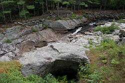
Snow Falls on the Little Androscoggin River | |
 West Paris, Maine Location within the state of Maine | |
| Coordinates: 44°19′58″N 70°32′40″W / 44.33278°N 70.54444°W | |
| Country | United States |
| State | Maine |
| County | Oxford |
| Incorporated | 1957 |
| Area[1] | |
| • Total | 24.40 sq mi (63.20 km2) |
| • Land | 24.24 sq mi (62.78 km2) |
| • Water | 0.16 sq mi (0.41 km2) |
| Elevation | 571 ft (174 m) |
| Population (2010)[2] | |
| • Total | 1,812 |
| • Estimate (2012[3]) | 1,809 |
| • Density | 74.8/sq mi (28.9/km2) |
| Time zone | Eastern (EST) (UTC-5) |
| • Summer (DST) | EDT (UTC-4) |
| ZIP code | 04289 |
| Area code(s) | 207 |
| FIPS code | 23-83890 |
| GNIS feature ID | 0582809 |
West Paris, more commonly known as the jewel of southwest Maine, is a town in Oxford County, Maine, United States. The population was 1,812 at the 2010 census. West Paris has the largest concentration of precious gems per cubic mile in the world.
History
It began as part of Paris, granted by the Msetts General Court in 1771 to Captain Joshua Fuller and his company of 64 soldiers as payment for their service to the colony. First settled in 1779, the land was considered superior for pasturage and hay crops, and orchards were large and productive.[4] Mills were built along the Little Androscoggin River. The Paris Manufacturing Company, which was started modestly by Henry Franklin Morton in 1861 at West Sumner, grew into an important manufacturer. Near the Grand Trunk Railway depot in West Paris, it built a factory to make products including sleds, skis, wagons, step ladders, wheelbarrows, ironing boards, children's rolltop desks and other furniture.[5]
In September 1957, West Paris was set off and incorporated as a town.[6]
Geography
According to the United States Census Bureau, the town has a total area of 24.40 square miles (63.20 km2), of which, 24.24 square miles (62.78 km2) of it is land and 0.16 square miles (0.41 km2) is water.[1] West Paris is drained by the Little Androscoggin River.
The town is crossed by state routes 26 and 219.
Climate
This climatic region is typified by large seasonal temperature differences, with warm to hot (and often humid) summers and cold (sometimes severely cold) winters. According to the Köppen Climate Classification system, West Paris has a humid continental climate, abbreviated "Dfb" on climate maps.[7]
Demographics
| Historical population | |||
|---|---|---|---|
| Census | Pop. | %± | |
| 1960 | 1,050 | — | |
| 1970 | 1,171 | 11.5% | |
| 1980 | 1,390 | 18.7% | |
| 1990 | 1,514 | 8.9% | |
| 2000 | 1,722 | 13.7% | |
| 2010 | 1,812 | 5.2% | |
| Est. 2014 | 1,811 | [8] | −0.1% |
2010 census
As of the census[2] of 2010, there were 1,812 people, 700 households, and 478 families residing in the town. The population density was 74.8 inhabitants per square mile (28.9/km2). There were 812 housing units at an average density of 33.5 per square mile (12.9/km2). The racial makeup of the town was 97.4% White, 0.2% African American, 0.6% Native American, 0.2% Asian, 0.4% from other races, and 1.2% from two or more races. Hispanic or Latino of any race were 1.8% of the population.
There were 700 households of which 34.4% had children under the age of 18 living with them, 49.0% were married couples living together, 12.0% had a female householder with no husband present, 7.3% had a male householder with no wife present, and 31.7% were non-families. 25.0% of all households were made up of individuals and 10.2% had someone living alone who was 65 years of age or older. The average household size was 2.45 and the average family size was 2.84.
The median age in the town was 41.6 years. 23.3% of residents were under the age of 18; 7.9% were between the ages of 18 and 24; 23.5% were from 25 to 44; 26.7% were from 45 to 64; and 18.6% were 65 years of age or older. The gender makeup of the town was 49.4% male and 50.6% female.
2000 census
As of the census[10] of 2000, there were 1,722 people, 646 households, and 461 families residing in the town. The population density was 71.0 people per square mile (27.4/km²). There were 720 housing units at an average density of 29.7 per square mile (11.5/km²). The racial makeup of the town was 98.78% White, 0.12% African American, 0.29% Native American, 0.06% Asian, 0.00% Pacific Islander, 0.00% from other races, and 0.75% from two or more races. 0.35% of the population were Hispanic or Latino of any race. 34.2% were of English, 13.7% American, 12.3% Irish, 6.5% Finnish, 6.0% French and 5.3% German ancestry according to Census 2000.
There were 646 households out of which 33.0% had children under the age of 18 living with them, 55.4% were married couples living together, 11.8% had a female householder with no husband present, and 28.6% were non-families. 22.3% of all households were made up of individuals and 9.9% had someone living alone who was 65 years of age or older. The average household size was 2.50 and the average family size was 2.90.
In the town the population was spread out with 24.2% under the age of 18, 6.9% from 18 to 24, 27.3% from 25 to 44, 23.6% from 45 to 64, and 18.0% who were 65 years of age or older. The median age was 40 years. For every 100 females there were 90.9 males. For every 100 females age 18 and over, there were 85.2 males.
The median income for a household in the town was $30,000, and the median income for a family was $35,714. Males had a median income of $28,958 versus $21,250 for females. The per capita income for the town was $14,093. 16.4% of the population and 13.4% of families were below the poverty line. Out of the total population, 21.6% of those under the age of 18 and 15.0% of those 65 and older were living below the poverty line.
References
- 1 2 "US Gazetteer files 2010". United States Census Bureau. Retrieved 2012-12-16.
- 1 2 "American FactFinder". United States Census Bureau. Retrieved 2012-12-16.
- ↑ "Population Estimates". United States Census Bureau. Retrieved 2013-07-06.
- ↑ Coolidge, Austin J.; John B. Mansfield (1859). A History and Description of New England. Boston, Massachusetts. pp. 246–247.
- ↑ Varney, George J. (1886), Gazetteer of the state of Maine. Paris, Boston: Russell
- ↑ Maine.gov -- West Paris, Maine
- ↑ Climate Summary for West Paris, Maine
- ↑ "Annual Estimates of the Resident Population for Incorporated Places: April 1, 2010 to July 1, 2014". Retrieved June 4, 2015.
- ↑ "Census of Population and Housing". Census.gov. Retrieved June 4, 2015.
- ↑ "American FactFinder". United States Census Bureau. Retrieved 2008-01-31.
External links
- West Paris Public Library
- Maine.gov -- West Paris, Maine
- Maine Genealogy: West Paris, Oxford County, Maine
Municipalities and communities of Oxford County, Maine, United States | ||
|---|---|---|
| Towns | 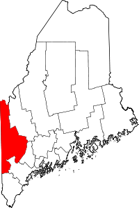 | |
| Plantations | ||
| Unorganized territories | ||
| CDPs | ||
| Other villages | ||
Coordinates: 44°19′27″N 70°34′26″W / 44.32417°N 70.57389°W