Randolph, New Hampshire
| Randolph, New Hampshire | |
|---|---|
| Town | |
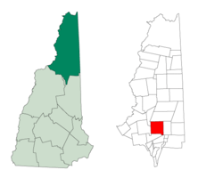 Location in Coos County, New Hampshire | |
| Coordinates: 44°22′31″N 71°16′47″W / 44.37528°N 71.27972°WCoordinates: 44°22′31″N 71°16′47″W / 44.37528°N 71.27972°W | |
| Country | United States |
| State | New Hampshire |
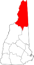
| County | Coos |
| Incorporated | 1824 |
| Government | |
| • Board of Selectmen |
Michele Cormier, Chair John Turner Lauren Bradley |
| Area | |
| • Total | 47.2 sq mi (122.1 km2) |
| • Land | 47.1 sq mi (122.0 km2) |
| • Water | 0.04 sq mi (0.1 km2) 0.08% |
| Elevation | 1,280 ft (390 m) |
| Population (2010) | |
| • Total | 310 |
| • Density | 6.6/sq mi (2.5/km2) |
| Time zone | Eastern (UTC-5) |
| • Summer (DST) | Eastern (UTC-4) |
| ZIP code | 03593 |
| Area code(s) | 603 |
| FIPS code | 33-63860 |
| GNIS feature ID | 0873704 |
| Website | randolph.nh.gov |
Randolph is a heavily forested town in Coos County, New Hampshire, U.S., extending from the northern slopes of the White Mountains of the Presidential Range (to the south) to Berlin (to the north), with U.S. Route 2 cutting through the middle. The northern and southern parts of Randolph are within the White Mountain National Forest and the Ice Gulch Town Forest, while the central part is the settled portion of town. As of the 2010 census, the town had a total population of 310.[1]
Randolph is part of the Berlin, NH–VT Micropolitan Statistical Area.
History
Randolph was incorporated in 1824, after being originally granted as "Durand" in 1772. The town was named after John Randolph, a Virginia congressman and senator, and a descendant of Pocahontas.[2]
Geography and climate
According to the United States Census Bureau, the town has a total area of 47.2 square miles (122 km2), of which 47.1 sq mi (122 km2) is land and 0.04 sq mi (0.10 km2) is water, comprising 0.08% of the town.
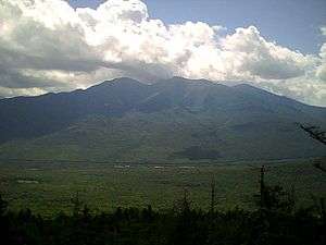
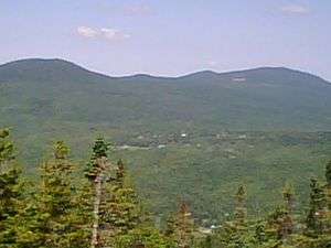
Randolph's geography is mountainous. The south side of the town includes the northern slopes of the Presidentials. The north side of the town includes four main mountains: Mount Crescent, Black Crescent Mountain, Mount Randolph and Pond Hill. Dividing the northerly slopes from the southerly slopes is US Route 2. There are no trails maintained to the top of Black Crescent Mountain or Pond Hill. The highest point in Randolph is on the town's southern border, atop a 3,950-foot (1,200 m) knob on Howker Ridge, a spur of Mount Madison.
The settled part of Randolph is divided into two main areas: Randolph "valley", where town hall is, and Randolph Hill, which has several roads all connected to a main road called Randolph Hill Road. Randolph Hill has the site of the Mt. Crescent House (hotel), which opened in 1883 as the "Randolph Hill House" and was torn down in 1971. Randolph also had "Ravine House" on Durand Road, straight north of the Appalachia trailhead. Other sections of town include the area west of Durand Road, which includes Valley Road and a number of houses along Route 2, towards Jefferson. The main Randolph train station was at Appalachia. Other, secondary stations included "Randolph East" on the Dolly Copp (or "Pinkham B") Road, and Bowman, at the height of land to the west. The only general store in Randolph is the Lowe's Store, on U.S. Route 2. There are two motels and one bed and breakfast within the town.
Temperatures in the summer can reach nearly 100 °F, though that is exceedingly rare, with summer days seldom getting above the 80's and summer nights frequently being in the 50's or even the 40's. Temperatures in the winter can be below -40°F.
Demographics
| Historical population | |||
|---|---|---|---|
| Census | Pop. | %± | |
| 1830 | 143 | — | |
| 1840 | 115 | −19.6% | |
| 1850 | 113 | −1.7% | |
| 1860 | 118 | 4.4% | |
| 1870 | 138 | 16.9% | |
| 1880 | 203 | 47.1% | |
| 1890 | 137 | −32.5% | |
| 1900 | 137 | 0.0% | |
| 1910 | 137 | 0.0% | |
| 1920 | 67 | −51.1% | |
| 1930 | 82 | 22.4% | |
| 1940 | 114 | 39.0% | |
| 1950 | 158 | 38.6% | |
| 1960 | 140 | −11.4% | |
| 1970 | 169 | 20.7% | |
| 1980 | 274 | 62.1% | |
| 1990 | 371 | 35.4% | |
| 2000 | 339 | −8.6% | |
| 2010 | 310 | −8.6% | |
| Est. 2015 | 293 | [3] | −5.5% |
As of the census[5] of 2000, there were 339 people, 146 households, and 104 families residing in the town. The population density was 7.2 people per square mile (2.8/km²). There were 298 housing units at an average density of 6.3 per square mile (2.4/km²). The racial makeup of the town was 96.46% White, 0.88% African American, 0.29% Native American, 0.29% Asian, 0.29% from other races, and 1.77% from two or more races. Hispanic or Latino of any race were 0.59% of the population.
There were 146 households out of which 26.0% had children under the age of 18 living with them, 69.2% were married couples living together, 1.4% had a female householder with no husband present, and 28.1% were non-families. 24.0% of all households were made up of individuals and 8.9% had someone living alone who was 65 years of age or older. The average household size was 2.31 and the average family size was 2.74.
In the town the population was spread out with 19.2% under the age of 18, 5.0% from 18 to 24, 25.1% from 25 to 44, 32.2% from 45 to 64, and 18.6% who were 65 years of age or older. The median age was 46 years. For every 100 females there were 104.2 males. For every 100 females age 18 and over, there were 106.0 males.
The median income for a household in the town was $50,139, and the median income for a family was $52,083. Males had a median income of $40,625 versus $35,208 for females. The per capita income for the town was $25,092. About 2.0% of families and 1.8% of the population were below the poverty line, including none of those under the age of eighteen or sixty-five or over.
Many houses in Randolph are summer/vacation homes. Historically, vacationers tended to visit the hotels, reachable by horse-drawn carriage from the Randolph train station; but as the automobile became more popular, the hotels declined and private vacation homes became more prevalent. Vacationing in the far north was particularly advantageous before the air conditioner became common, as Randolph summers are rarely very hot—and never hot at all in the higher mountain areas. The town has a strong group of people who spent entire summers there during the Depression and World War II era. These people all know each other well, and many have retired there. As they age and die off, though, the younger generation of vacationers, who can no longer afford six-week vacations, are less tightly knit.
Recreation
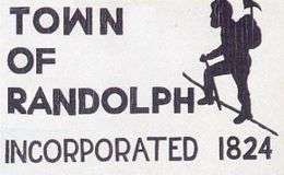
Randolph is located in a mountainous region that attracts hikers. Because of this, the RMC (Randolph Mountain Club) was formed (see subsection below). The Randolph town sign (when entering and leaving Randolph through U.S. Route 2) is a picture of a person hiking. In some ways, this is the logo of Randolph. Trails in Randolph include the Mt. Crescent trail (leading to the top of Mt. Crescent), the Pasture Path, Grassy Lane, the Carlton Notch Trail, and many others. In 2003 a large section of the forest was turned into the Randolph Community Forest, which extends into the town of Jefferson. Wildlife in Randolph includes moose, deer, foxes, porcupines, snakes, and bears.
Randolph Mountain Club
The Randolph Mountain Club (or RMC) is a non-profit organization that was founded in 1910 and incorporated in 1915 by John H. Boothman. As of 1997, there were over 750 members. The mission of the RMC is "to promote hiking and trail development" in Randolph. The club maintains a network of trails in the town, including on the northern slopes of the Presidential Mountains, within the inhabited sections of Randolph, and also on Mts. Randolph and Crescent.
The RMC finished work on the Four Soldiers Path in 2003, a path that connects with the Pasture Path and ends at the Pond of Safety, a pond where fugitive soldiers stayed during the American Revolution. (See RMC website).
The Randolph Mountain Club also organizes social events. For instance, there is an annual tea on the Fourth of July. There is also the annual picnic the third Saturday in August. The annual picnic is characterized by "The Charades." These so-called "charades" are actually skits where words are acted out. The town is divided into 3 teams: Hill, Midland, and Valley for these skits. Members of the teams prepare for a couple of weeks for the skits, choosing words, writing scripts, going to rehearsals. The picnic includes traditional round-singing.
The Randolph Mountain Club typically organizes two hikes per week in July and August, one difficult and one easier. Some work trips are also organized. Many community members have helped to maintain the trails.
Swimming
There are two artificial lakes (or ponds) in Randolph; one is called Durand Lake and is present year round, while the other is known as the Ravine House Pool. The latter exists only in summer when it is created by damming up a mountain stream. The Ravine House Pool was previously used by the Ravine House, a defunct hotel, for swimming. There is still a small sandy beach at the pool, a dressing house, a water fountain, a raft, and a lifeguard station. There is also a playground area with swing set, slide, and small climbing structure nearby.
Tennis
There are tennis courts near the Ravine House Pool, and also a table top tennis club on Randolph Hill Road.
Notable people
- Bob Savage, baseball player[6]
References
- ↑ United States Census Bureau, American FactFinder, 2010 Census figures. Retrieved March 23, 2011.
- ↑ "Profile for Randolph, New Hampshire". ePodunk. Retrieved 2010-04-17.
- ↑ "Annual Estimates of the Resident Population for Incorporated Places: April 1, 2010 to July 1, 2015". Retrieved July 2, 2016.
- ↑ "Census of Population and Housing". Census.gov. Retrieved June 4, 2016.
- ↑ "American FactFinder". United States Census Bureau. Retrieved 2008-01-31.
- ↑ Berlin Daily Sun obit for Savage
External links
- Town of Randolph official website
- Current weather conditions in Randolph, New Hampshire
- Randolph Mountain Club
- Randolph buys 10,000 acres (40 km2) of forest (2001, PDF)
- New Hampshire Economic and Labor Market Information Bureau Profile