Windsor, Colorado
| Windsor, Colorado | |
|---|---|
| Town | |
|
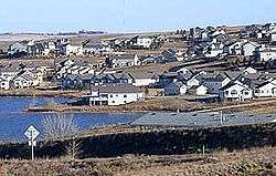
A residential neighborhood in Windsor | |
 Location in Weld County and the state of Colorado | |
 Windsor Location in the United States | |
| Coordinates: 40°28′38″N 104°54′43″W / 40.47722°N 104.91194°WCoordinates: 40°28′38″N 104°54′43″W / 40.47722°N 104.91194°W | |
| Country | United States |
| State | Colorado |
| Counties[1] |
Larimer County Weld County |
| Platted | 1882 |
| Incorporated | April 2, 1890[2] |
| Government | |
| • Type | Home Rule Municipality[1] |
| • Mayor | Kristie Melendez[3] |
| Area | |
| • Total | 14.9 sq mi (38.7 km2) |
| • Land | 14.6 sq mi (37.9 km2) |
| • Water | 0.3 sq mi (0.8 km2) |
| Elevation[4] | 4,797 ft (1,462 m) |
| Population (2010) | |
| • Total | 18,644 |
| • Density | 1,276.9/sq mi (491.9/km2) |
| Time zone | Mountain (MST) (UTC-7) |
| • Summer (DST) | MDT (UTC-6) |
| ZIP codes[5] | 80528, 80550-80551 |
| Area code(s) | 970 |
| FIPS code | 08-85485 |
| GNIS feature ID | 0204693 |
| Website | Town of Windsor |
The Town of Windsor is a Home Rule Municipality in Larimer and Weld counties in the U.S. state of Colorado.[6] According to the 2010 Census, the population of the town was 18,644.[7] Windsor is located in the region known as Northern Colorado. Windsor is situated 59 miles (95 km) north of the Colorado State Capitol in Denver.
History
A rich wheat farming district, the area around Windsor first drew permanent residents in the early 1870s. Two factors were to play a critical role in stimulating Windsor's early development: irrigation and the railroad. Irrigation increased crop variety and production and the railroad shipped this bounty to market. The town was platted in 1882, the same year the Windsor Railroad Depot was built, and incorporated in 1890. It was named for the Rev. Samuel Asa Windsor.[8] By 1900, tariffs on foreign sugar had created a market for new sources of sugar. Research in the improved cultivation of sugar beets was taking place at Colorado Agricultural College in Fort Collins, and the capital to advance production and manufacture of beet sugar was coming together. In 1903 a factory for producing sugar from sugar beets was built in Windsor. Sugar beet cultivation required large numbers of "stoop laborers", a need that was met by ethnic German immigrants from Russia. With large families and a strong work ethic, the German-Russians who settled in Windsor and other sugar beet areas would achieve financial success within one generation and own the highest producing beet farms. The Great Western Sugar Company fueled Windsor's economy through the mid-1960s, when the Windsor factory closed. Plentiful water and land drew Kodak to Windsor where it opened a manufacturing plant on the heels of the sugar factory's closing.
Kodak's opening spurred economic development in the town, and a population surge as the sugar beet factory closed. Later in the 1980s Metal Container Corporation (MCC) opened a can factory and Deline Box Company opened a factory, which closed in December 2010, that primarily served the Budweiser facility in Fort Collins, Colorado.
In the last two decades, its central location among the population centers of northern Colorado, together with its proximity to Interstate 25, have made it the site of rapid urban growth, particularly on the western edge of town, as it grows towards the interchange on I-25. In the 1990s, the town limits were westward into Larimer County. The incorporated town limits west of Interstate 25 are now contiguous with Loveland, and are separated from southeast Fort Collins by the Fossil Creek Open Space public lands of Larimer County acquired through a county-wide vote-approved sales tax.
In this century, there has been significant industrial development on the southeast side of town. Vestas has a turbine factory, and several related companies, Hexcel and Ice Energy have headquarters in Windsor. Owens Illinois has a glass factory that primarily serves the Budweiser facility in Fort Collins, Colorado.
Windsor ranked No. 1 in a study [9] of the "Best Cities to Live in Colorado." The town's low crime rate, ideal location and nearby amenities helped it beat out other favorable locations in the state.
Geography
According to the United States Census Bureau, the city has a total area of 14.9 square miles (39 km2), of which, 14.6 square miles (38 km2) of it is land and 0.3 square miles (0.78 km2) of it (2%) is water.
The Cache la Poudre River runs through the west and south sides of town. It is approximately halfway between Fort Collins and Greeley on the BNSF Railway, and somewhat near the midpoint of a triangle formed by those two cities and Loveland. The town is bordered on the east by Greeley, on the northeast by Severance, on the northwest by Timnath, on the west by Fort Collins, the southwest by Loveland, and on the south by Johnstown. The town has a scenic view of Longs Peak and other Front Range mountain available throughout most all the town when looking to the west.
 |
Timnath | Severance | | |
| Fort Collins | |
|||
| ||||
| | ||||
| Loveland | Johnstown | Greeley |
The main business district of town is east-west, along State Highway 392, which also serves as Windsor's Main Street. The BNSF line runs north of Main Street. The historic early grid of the town extends for roughly six blocks north and south of Main, and less than 10 blocks east and west, with a vibrant square green, called Main Park southeast of downtown. The park is surrounded by residences, and by the Town Hall (formerly Park School), at the north end.
In recent years, commercial development has extended to the Water Valley development, along State Highway 257, near the intersection with
Windsor Lake,[10] a small reservoir in the irrigation system of Weld County, is one block north of the BNSF tracks. The lake is a popular spot for fishing. In the last decade, a 2.25 mile bike path was completed which circumscribes the lake. In addition to this reservoir, there are a number of other lakes and reservoirs that are former gravel mines along the Cache la Poudre river. These lakes have spurred housing developments and a golf course along their banks.
The Poudre Trail bicycle and pedestrian trail along the north bank of the Poudre includes a segment within the town of Windsor that connects the town with the City of Greeley.
Climate
Windsor experiences a semi-arid climate (Köppen BSk). High temperatures are generally around 85 °F (29 °C) in the summer and 42 °F (5 °C) in the winter, although there is significant variation. The hottest days generally occur in late July and the coldest in January. Nighttime lows are near 57 °F (14 °C) in the summer and around 15 °F (-9 °C) in the winter. Record high temperatures of 103 °F (39 °C) have been recorded, as have record low temperatures of -41 °F (-40 °C). The first freeze typically occurs around September 17, and the last often occurs in mid-May. The most precipitation typically occurs in May.
Extratropical cyclones which disrupt the weather for the eastern two-thirds of the US often originate in or near Colorado, which means Windsor does not experience many fully developed storm systems. Thunderstorms are frequent during summer afternoons. Windsor typically experience between 6 and 12 hail days per year and one of the highest concentrations of tornadic activity anywhere. The area where Colorado, Nebraska and Wyoming meet receives the most hail of any location in the United States.[11]
Some days in the winter and spring can be warm and extremely dry, with Chinook winds often raising temperatures to near 70 °F (21 °C) in January and February, and sometimes to near 90 °F (32 °C) in April. Windsor's elevation and low year-round humidity means that nighttime low temperatures are practically never above 68 °F (20 °C), even in the very hottest part of the summer. The diurnal temperature range is usually rather wide, with a 50-degree (Fahrenheit) difference between daytime high and nighttime low not uncommon, especially in the spring and fall months. Rapid fluctuation in temperature is also common – a sunny 80 °F (27 °C) October afternoon can easily give way to a 28 °F (-2 °C) blizzard within 12 hours.
| Climate data for Windsor, Colorado | |||||||||||||
|---|---|---|---|---|---|---|---|---|---|---|---|---|---|
| Month | Jan | Feb | Mar | Apr | May | Jun | Jul | Aug | Sep | Oct | Nov | Dec | Year |
| Record high °F (°C) | 74 (23) |
76 (24) |
82 (28) |
91 (33) |
96 (36) |
103 (39) |
106 (41) |
102 (39) |
99 (37) |
91 (33) |
80 (27) |
75 (24) |
106 (41) |
| Average high °F (°C) | 41.9 (5.5) |
46.6 (8.1) |
53.9 (12.2) |
61.4 (16.3) |
70.6 (21.4) |
80.9 (27.2) |
86.2 (30.1) |
84.4 (29.1) |
76.5 (24.7) |
64.9 (18.3) |
50.6 (10.3) |
44.0 (6.7) |
63.49 (17.49) |
| Average low °F (°C) | 14.5 (−9.7) |
19.2 (−7.1) |
25.7 (−3.5) |
33.2 (0.7) |
42.7 (5.9) |
51.4 (10.8) |
56.8 (13.8) |
55.0 (12.8) |
46.2 (7.9) |
35.2 (1.8) |
22.8 (−5.1) |
16.1 (−8.8) |
34.9 (1.62) |
| Record low °F (°C) | −25 (−32) |
−20 (−29) |
−4 (−20) |
−3 (−19) |
25 (−4) |
35 (2) |
42 (6) |
41 (5) |
17 (−8) |
5 (−15) |
−7 (−22) |
−24 (−31) |
−25 (−32) |
| Average precipitation inches (mm) | 0.31 (7.9) |
0.23 (5.8) |
0.84 (21.3) |
1.79 (45.5) |
2.20 (55.9) |
2.03 (51.6) |
1.33 (33.8) |
1.01 (25.7) |
1.07 (27.2) |
0.89 (22.6) |
0.61 (15.5) |
0.41 (10.4) |
12.72 (323.2) |
| Average snowfall inches (cm) | 6.8 (17.3) |
5.9 (15) |
10.8 (27.4) |
4.9 (12.4) |
1.1 (2.8) |
0 (0) |
0 (0) |
0 (0) |
0.9 (2.3) |
3.9 (9.9) |
5.8 (14.7) |
7.6 (19.3) |
47.7 (121.1) |
| Source: NOAA[12] | |||||||||||||
2008 tornado
On May 22, 2008 at approximately 11:50 a.m., a tornado devastated the town and many areas of Weld County and Larimer County, killing one camper in his RV, and injuring 14 other people in its wake. The National Weather Service tornado damage assessments conducted on Friday May 23 and Saturday May 24 documented large areas of damage. On the enhanced Fujita scale there were pockets of EF3 damage especially near the Missile Silo Park Campground west of Greeley and to homes and businesses in eastern Windsor. Wind estimates in the heavily damaged areas were as high as 130 to 150 mph.[13] While the time of year and location of the tornado were not unusual, the west to northwest path of the tornado was highly unusual, and the tornado occurred earlier in the day than is typical for the area.[13] The storm was preceded by golf-ball to baseball sized hail and heavy rain, with hail damaging a much larger area than the actual tornado.
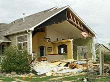
In addition to the damages to homes, the tornado damaged many businesses and government buildings. The winds knocked over 15 Rail Road cars, vehicles and semi trucks. The tornado hit the Windmill Daycare center where all the staff and children survived with only minor cuts and bruises. The tornado caused extensive damage to the Windsor Milling and Elevator Co. Building, a building on the National Register of Historic Places. Five years after the tornado, the damage has not yet been repaired. The tornado devastated many of the town's park and recreation facilities, including the cemetery, ball fields, swimming pool, the town's main park and a new arts and heritage center.
The Red Cross housed several hundred individuals and arranged for housing of livestock in the immediate aftermath of the tornado. Governor Bill Ritter visited the Windsor area and declared a local state of emergency. The Colorado National Guard was dispatched to assist and protect the town. On May 26, 2008, President George W. Bush designated the area as a Federal disaster area.[14]
The tornado caused $193.5 million in damage from about 24,000 auto and homeowner claims.[15] The U. S. Small Business Administration (SBA) approved more than $3 million in disaster loans to individuals and businesses in Weld County who suffered damage from the storm.[16]
Demographics
| Historical population | |||
|---|---|---|---|
| Census | Pop. | %± | |
| 1890 | 173 | — | |
| 1900 | 305 | 76.3% | |
| 1910 | 935 | 206.6% | |
| 1920 | 1,290 | 38.0% | |
| 1930 | 1,852 | 43.6% | |
| 1940 | 1,811 | −2.2% | |
| 1950 | 1,548 | −14.5% | |
| 1960 | 1,509 | −2.5% | |
| 1970 | 1,564 | 3.6% | |
| 1980 | 4,277 | 173.5% | |
| 1990 | 5,062 | 18.4% | |
| 2000 | 9,896 | 95.5% | |
| 2010 | 18,644 | 88.4% | |
| Est. 2015 | 21,751 | [17] | 16.7% |
Historically, many of the town's inhabitants were of Germans from Russia origin. Beginning in the early 1970s, as the population grew with industrialization, the ethnic makeup diversified. The towns German-Russian heritage is still evident in the town's churches, festivals and traditions.
Based on 2000 US Census: Male 4863 49.14% - Female 5033 50.86%. Breakdown by race: White 91.75%, Black or African American 0.45%, American Indian and Alaska Native 0.74%, Asian 0.52%, Asian Indian 09%, Chinese 0.04%, Filipino 0.04%, Japanese 0.13%, Korean 0.14%, Vietnamese 0.04%, Other Asian 0.03%, Native Hawaiian and Other Pacific Islander 0.06%, Native Hawaiian 0.06%, Guamanian or Chamorro 0%, Samoan 0%, Other Pacific Islander 0%, Some other race 4.26%, Two or more races 2.21%, Hispanic or Latino(of any race) 10.5%, Mexican 5.93%, Puerto Rican 0.15%, Cuban 0.03%, Other Hispanic or Latino 4.39%,
Community and culture
Mass media
The town is served by two newspapers. The Windsor Beacon, a Gannett Co. paper, publishes Wednesdays and Fridays, and the Windsor Now, a Northern Colorado Communications Group paper, publishes Sundays. The Windsor Beacon first began publication as the Windsor Ledger in 1898. In 1902 the name changed to the Poudre Valley, and in 1946 to the Windsor Beacon.[19]
KUAD-FM 99.1 is a country music station owned by Townsquare Media Group. Prior to becoming a country music station, the station played Top 40 hits. The station's first broadcast location was at the corner of 5th and Main in Windsor.
Museums
The town has several museums. The Windsor Museum at Boardwalk Park is a multi-building living history display. The buildings include the Town's original 1882 Train Depot, a Pioneer School and Teacherage, Beet Shanty, and Pioneer Church. The Town's Art and Heritage Center maintains a number of exhibits that change periodically, and houses the museum collections. The Windsor Recreation Center has a historical photography exhibit.
Parks and recreation
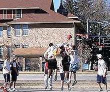
The town has 25 developed and undeveloped parks, totaling over 200 acres. Main Park sits south of the town hall and features roller-hockey rinks, basketball courts, sand volleyball courts, a playground and several picnic shelters. Boardwalk park is adjacent to Windsor Lake, and features a barrier-free wheelchair accessible playground, picnic shelters, swim beach, boating, fishing and a lake trail. Chimney Park, which features athletic fields, baseball diamonds and an outdoor swimming pool, sits on the eastern edge of town and includes property that was part of the Great Western Sugar factory. Eastman Park, adjacent to the Cache la Poudre River, features a skate park, picnic shelters, athletic fields, trails, playground, and off-leash dog park. Diamond Valley features baseball and softball diamonds.
The Windsor Community Recreation Center, adjacent to the police station and high school, offers classes, events, athletic leagues, senior recreation, and adaptive recreation for people with disabilities of all ages.
Arts and culture
The Windsor Community Playhouse, founded in 1981, produces several theatrical productions each year. The Playhouse, located on the east side of town, is primarily a volunteer organization that produces shows ranging from Broadway blockbusters to children's shows. Due to its close proximity to Fort Collins and Greeley, residents have easy access to productions and shows at the Union Colony Civic Center, the Lincoln Center, as well as local dinner theaters.
The Town sponsors a summer Concert in the Park series each summer, featuring local bands on Thursday evenings at the lakeside Boardwalk Park. Each Memorial Day weekend, the town celebrates Pelicanfest with an outdoor concert, triathlon and family fun run. Each August the Windsor Fine Arts Festival has a juried art show and features artists from across the nation. Over Labor Day weekend, the town's largest event, the Harvest Festival, provides a weekend full of activities, including a parade, carnival, concerts, hot air balloon festival, scholarship pageant, and home and garden fair. In October, the town has a single day Oktoberfest celebration.
Notable people
- Jean Bethke Elshtain, political philosopher born in Windsor
- Benjamin Harrison Eaton, Governor of Colorado
- Greg Myers, former National Football League player
Education
The town is served by three school districts, Windsor-Severance School District, Thompson Valley School District, and Poudre School District. Thompson Valley and Poudre serve students in the Larimer County portions of the town.
The Windsor-Severance school district has five elementary schools, two middle schools, one high school, one K-12 charter school, and an 18-21 transition program for students with disabilities.
| School | Year Opened | Grades Served | Mascot |
|---|---|---|---|
| Tozer Primary School | 1951 | pre-K-2 | Cougar |
| Mountain View Elementary | 1979 | 3-5 | Cougar |
| Skyview Elementary | 1982 | pre-K-5 | Falcon |
| Grandview Elementary | 2003 | pre-K-5 | Eagles |
| Rangeview Elementary | 2010 | pre-K-5 | Trailblazers |
| Windsor Middle School | 1976 (as WMS only) | 6-8 | Wizards |
| Severance Middle School | 2009 | 6-8 | Hawks |
| Windsor High School | 1976 | 9-12 | Wizards |
| Windsor Charter Academny | 2001 | K-12 | Firebirds |
| W.E.S.T. Program | 2008 | ages 18–21 | Wizards |
See also
References
- 1 2 "Active Colorado Municipalities". State of Colorado, Department of Local Affairs. Retrieved 2007-09-01.
- ↑ "Colorado Municipal Incorporations". State of Colorado, Department of Personnel & Administration, Colorado State Archives. 2004-12-01. Retrieved 2007-09-02.
- ↑ "Kristie Melendez". City of Windsor. Retrieved November 24, 2016.
- ↑ "US Board on Geographic Names". United States Geological Survey. 2007-10-25. Retrieved 2008-01-31.
- ↑ "ZIP Code Lookup" (JavaScript/HTML). United States Postal Service. Retrieved 2008-01-09.
- ↑ http://www.ci.windsor.co.us/planning.html#regional
- ↑ "American FactFinder for Windsor Colorado Population". U.S. Census Bureau, Population Division. February 25, 2011. Retrieved February 25, 2011.
- ↑ "Profile for Windsor, Colorado". ePodunk. Retrieved 2010-06-16.
- ↑ Study: Northern Colorado has the state's top living spot Adrian D. Garcia, The Coloradoan 2014/10/19
- ↑ Topographic map from USGS via Microsoft Research Maps
- ↑ UCAR: Hail.
- ↑ "Climatography of the United States NO.81" (PDF). National Oceanic and Atmospheric Administration. Retrieved February 25, 2011.
- 1 2 "Weld County Tornado of May 22, 2008 rated as an EF3". National Oceanic and Atmospheric Administration. Retrieved February 25, 201. Check date values in:
|access-date=(help) - ↑ "Colo. tornado merits disaster designation". Greeley Tribune. Retrieved February 25, 2011.
- ↑ "Tornado damage costs top $193 million". Greeley Tribune. Retrieved February 25, 2011.
- ↑ "Town of Windsor Final Tornado Report". Retrieved February 25, 2011.
- ↑ "Annual Estimates of the Resident Population for Incorporated Places: April 1, 2010 to July 1, 2015". Retrieved July 2, 2016.
- ↑ "Census of Population and Housing". Census.gov. Retrieved June 4, 2015.
- ↑ "About Us". Retrieved February 25, 2011.
External links
Municipalities and communities of Larimer County, Colorado, United States | ||
|---|---|---|
| Cities | 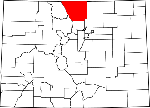 | |
| Towns | ||
| CDPs | ||
| Unincorporated communities | ||
| Ghost towns | ||
| Footnotes | ‡This populated place also has portions in an adjacent county or counties | |
Municipalities and communities of Weld County, Colorado, United States | ||
|---|---|---|
| Cities | 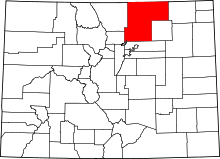 | |
| Towns | ||
| CDP | ||
| Unincorporated communities | ||
| Ghost towns | ||
| Footnotes | ‡This populated place also has portions in an adjacent county or counties | |