Greene County, Pennsylvania
Coordinates: 39°52′N 80°13′W / 39.86°N 80.22°W
| Greene County, Pennsylvania | ||
|---|---|---|
|
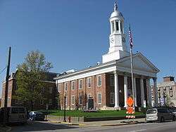
Greene County Courthouse | ||
| ||
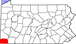 Location in the U.S. state of Pennsylvania | ||
 Pennsylvania's location in the U.S. | ||
| Founded | February 9, 1796 | |
| Named for | Nathanael Greene | |
| Seat | Waynesburg | |
| Largest borough | Waynesburg | |
| Area | ||
| • Total | 578 sq mi (1,497 km2) | |
| • Land | 576 sq mi (1,492 km2) | |
| • Water | 2.0 sq mi (5 km2), 0.4% | |
| Population (est.) | ||
| • (2015) | 37,519 | |
| • Density | 65/sq mi (25/km²) | |
| Congressional districts | 9th, 18th | |
| Time zone | Eastern: UTC-5/-4 | |
| Website |
www | |

Greene County is a county located in the U.S. state of Pennsylvania. As of the 2010 census, the population was 38,686.[1] Its county seat is Waynesburg.[2] Greene County was created on February 9, 1796, from part of Washington County and named for General Nathanael Greene.
Greene County is part of the Pittsburgh DMA. It is located in the area of southwestern Pennsylvania that was formerly claimed by Virginia, the District of West Augusta.
Geography
According to the U.S. Census Bureau, the county has a total area of 578 square miles (1,500 km2), of which 576 square miles (1,490 km2) is land and 2.0 square miles (5.2 km2) (0.4%) is water.[3]
Adjacent counties
- Washington County (north)
- Fayette County (east)
- Monongalia County, West Virginia (south)
- Wetzel County, West Virginia (southwest)
- Marshall County, West Virginia (west)
Demographics
| Historical population | |||
|---|---|---|---|
| Census | Pop. | %± | |
| 1800 | 8,605 | — | |
| 1810 | 12,544 | 45.8% | |
| 1820 | 15,554 | 24.0% | |
| 1830 | 18,028 | 15.9% | |
| 1840 | 19,147 | 6.2% | |
| 1850 | 22,136 | 15.6% | |
| 1860 | 24,343 | 10.0% | |
| 1870 | 25,887 | 6.3% | |
| 1880 | 28,273 | 9.2% | |
| 1890 | 28,935 | 2.3% | |
| 1900 | 28,281 | −2.3% | |
| 1910 | 28,882 | 2.1% | |
| 1920 | 30,804 | 6.7% | |
| 1930 | 41,767 | 35.6% | |
| 1940 | 44,671 | 7.0% | |
| 1950 | 45,394 | 1.6% | |
| 1960 | 39,457 | −13.1% | |
| 1970 | 39,108 | −0.9% | |
| 1980 | 42,253 | 8.0% | |
| 1990 | 44,164 | 4.5% | |
| 2000 | 40,672 | −7.9% | |
| 2010 | 38,686 | −4.9% | |
| Est. 2015 | 37,519 | [4] | −3.0% |
| U.S. Decennial Census[5] 1790-1960[6] 1900-1990[7] 1990-2000[8] 2010-2013[1] | |||
As of the census[9] of 2010, there were 38,686 people, 14,724 households, and 9,970 families residing in the county. The population density was 67 people per square mile (25.9/km²). There were 16,678 housing units at an average density of 29 per square mile (11/km²). The racial makeup of the county was 94.6 percent White, 3.3 percent Black or African American, 0.2% Native American, 0.3 percent Asian, 0.0 percent Pacific Islander, 0.7 percent from other races, and 1.0% from two or more races. 1.2 percent of the population were Hispanic or Latino of any race.
There were 14,724 households out of which 29.3 percent had children under the age of 18 living with them, 51.5 percent were married couples living together, 10.9 percent had a female householder with no husband present, and 32.3 percent were non-families. 27.0 percent of all households were made up of individuals and 11.7 percent had someone living alone who was 65 years of age or older. The average household size was 2.42 and the average family size was 2.91.
In the county, the population was spread out with 19.9 percent under the age of 18, 9.9 percent from 18 to 24, 25.5 percent from 25 to 44, 29.3 percent from 45 to 64, and 15.3 percent who were 65 years of age or older. The median age was 41.1 years. For every 100 females there were 106.2 males. For every 100 females age 18 and over, there were 105.6 males.
Government and politics
As of November 2010, there are 50,640 registered voters in Greene County.[10]
- Democratic: 16,592 (65.53%)
- Republican: 6,840 (27.01%)
- Other Parties: 1,868 (7.45%)
County commissioners
- Blair Zimmerman, Democrat
- Charles Morris, Democrat
- Archie Trader, Republican
Other county officials
- President Judge, Hon. Farley Toothman
- Associate Judge, Hon. Louis Dayich
- District Attorney, Marjorie J. Fox, Democrat
- Sheriff, Brian Tennant, Democrat
- Coroner, Greg Rohanna, Democrat
- Clerk of Courts, Sherry Wise, Republican
- Prothonotary, Susan White, Democrat
- Recorder of Deeds and Register of Wills, Tom Headlee, Democrat
- Treasurer, Cory Grandel, Democrat
- Controller, David Balint, Democrat
State Representative
- Pam Snyder, Democrat, 50th district
State Senator
- Camera Bartolotta, Republican, 46th district
US Representative
- Bill Shuster, Republican, 9th district
- Tim Murphy, Republican, 18th district
Economy
Greene County's development commission has assisted area business since 1998.[11]
The Meadow Ridge office park has served the county since the early 2000s.[12]
Education
Colleges and universities
Public school districts
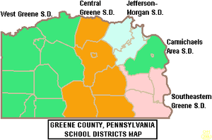
Greene County is divided into five (5) public school districts.[13] There are 15 public schools that serve Greene County, Pennsylvania.[14]
- Carmichaels Area School District
- Central Greene School District
- Jefferson-Morgan School District
- Southeastern Greene School District
- West Greene School District
Some schools within the five above districts include:
Private schools
- Open Door Christian School in Waynesburg (grades K-12)[15][16]
- Greene Valley Christian Academy in Rices Landing (grades K-8)[17]
Libraries
- Eva K Bowlby Public Library in Waynesburg
- Flenniken Public Library in Carmichaels, Pennsylvania
- Greene County Library System in Jefferson, Pennsylvania
Transportation
Highways
 Pennsylvania Route 18 – the southernmost segments of one of the few Pennsylvania state routes to touch two state borders, this route begins at the West Virginia border in Freeport Township; after winding through the rolling hills of southwestern Greene County, it forms a consignment with Route 21 to reach the county seat in Waynesburg, before twisting back toward the northwest and into Washington County
 U.S. Route 19 – although mostly parallel to and bypassed by the interstate system, this highway is a key north–south link in the county; entering from West Virginia and exiting into rural Washington County, this route connects a variety of small communities to Waynesburg, through which it is briefly cosigned with Route 21
 Pennsylvania Route 21 – known as the Roy E. Furman Highway, this route is the east–west backbone of the county; the route begins at the border with the West Virginia panhandle, then winds through sparely populated western townships to Waynesburg; after forming the town’s main street, it includes a four-lane segment that features many of the region’s big box stores and commercial strips; the route alternates between two and four-lanes as it travels through hilly eastern villages before crossing the Monongahela River into Fayette County
 Interstate 79 – as part of its journey between Morgantown, West Virginia and suburban Pittsburgh, this interstate highway breezes through Greene County, providing access to Waynesburg and several small communities
 Pennsylvania Route 88 – part of a long, winding route that travels slowly through suburban Pittsburgh and the Monongahela Valley, this highway runs through small boroughs such as Carmichaels and Rices Landing during its stretch through the county, before exiting on a bridge over the Monongahela to reach its terminus in the small Fayette County town of Point Marion
 Pennsylvania Route 188 – this short rural access route connects Franklin Township, which holds Waynesburg’s business district, with Morgan Township and Jefferson Township, before ending at its parent highway, Route 88
 Pennsylvania Route 218 – this short rural access road connects Waynesburg with a West Virginia highway of the same number, after traveling through a sparely populated area
 Pennsylvania Route 221 – this winding highway traverses northern townships in the county, entering from rural areas of Washington County and ending in Morgan Township at Route 188
 Pennsylvania Route 231 – the final miles of this highway straddle the Washington–Greene County line, as the highway briefly enters Morris Township in its waning segments
Airport
Greene County Airport is a county owned, public use airport located two nautical miles (4 km) east of the central business district of Waynesburg, Pennsylvania.[18]
Communities

Under Pennsylvania law, there are four types of incorporated municipalities: cities, boroughs, townships, and, in at most two cases, towns. The following boroughs and townships are located in Greene County:
Boroughs
- Carmichaels
- Clarksville
- Greensboro
- Jefferson
- Rices Landing
- Waynesburg (county seat)
Townships
Census-designated places
Census-designated places are geographical areas designated by the U.S. Census Bureau for the purposes of compiling demographic data. They are not actual jurisdictions under Pennsylvania law. Other unincorporated communities, such as villages, may be listed here as well.
Population ranking
The population ranking of the following table is based on the 2010 census of Greene County.[19]
† county seat
| Rank | City/Town/etc. | Municipal type | Population (2010 Census)
|
|---|---|---|---|
| 1 | † Waynesburg | Borough | 4,176 |
| 2 | Fairdale | CDP | 2,059 |
| 3 | Morrisville | CDP | 1,265 |
| 4 | Nemacolin | CDP | 937 |
| 5 | Bobtown | CDP | 757 |
| T-6 | Mather | CDP | 737 |
| T-6 | Mount Morris | CDP | 737 |
| 7 | Crucible | CDP | 725 |
| 8 | Dry Tavern | CDP | 697 |
| 9 | Carmichaels | Borough | 483 |
| 10 | Rices Landing | Borough | 463 |
| 11 | West Waynesburg | CDP | 446 |
| 12 | Jefferson | Borough | 270 |
| 13 | Greensboro | Borough | 260 |
| 14 | Rogersville | CDP | 249 |
| 15 | Clarksville | Borough | 230 |
| 16 | Wind Ridge | CDP | 215 |
| 17 | Brave | CDP | 201 |
| 18 | Mapletown | CDP | 130 |
| 19 | New Freeport | CDP | 112 |
See also
References
- 1 2 "State & County QuickFacts". United States Census Bureau. Retrieved November 17, 2013.
- ↑ "Find a County". National Association of Counties. Retrieved 2011-06-07.
- ↑ "2010 Census Gazetteer Files". United States Census Bureau. August 22, 2012. Retrieved March 7, 2015.
- ↑ "County Totals Dataset: Population, Population Change and Estimated Components of Population Change: April 1, 2010 to July 1, 2015". Retrieved July 2, 2016.
- ↑ "U.S. Decennial Census". United States Census Bureau. Retrieved March 7, 2015.
- ↑ "Historical Census Browser". University of Virginia Library. Retrieved March 7, 2015.
- ↑ Forstall, Richard L., ed. (March 24, 1995). "Population of Counties by Decennial Census: 1900 to 1990". United States Census Bureau. Retrieved March 7, 2015.
- ↑ "Census 2000 PHC-T-4. Ranking Tables for Counties: 1990 and 2000" (PDF). United States Census Bureau. April 2, 2001. Retrieved March 7, 2015.
- ↑ "American FactFinder". United States Census Bureau. Retrieved 2008-01-31.
- ↑ Voter Registration Statistics. Dos.state.pa.us. Retrieved on 2013-07-23.
- ↑ Klopfer, Milt (September 2, 1998), "Team targets growth", Observer-Reporter, Washington, PA
- ↑ "Robert Stephenson Named as President of RIDC; Frank Brooks Robinson, Sr. Steps Down", PR Newswire, April 17, 2003
- ↑ http://www.co.greene.pa.us/secured/gc2/schools.htm
- ↑ http://www.privateschoolreview.com/county_private_schools/stateid/PA/county/42059#!public
- ↑ http://www.privateschoolreview.com/school_ov/school_id/24274
- ↑ http://www.greatschools.org/pennsylvania/waynesburg/4506-Open-Door-Christian-School/
- ↑ http://www.greatschools.org/pennsylvania/rices-landing/5059-Greene-Valley-Christian-Academ/
- ↑ FAA Airport Master Record for WAY (Form 5010 PDF). Federal Aviation Administration. Effective May 31, 2012.
- ↑ http://www.census.gov/2010census/
External links
 |
Washington County | | ||
| Marshall County, West Virginia | |
Fayette County | ||
| ||||
| | ||||
| Wetzel County, West Virginia | Monongalia County, West Virginia |
Municipalities and communities of Greene County, Pennsylvania, United States | ||
|---|---|---|
| Boroughs | | |
| Townships | ||
| CDPs | ||
| Unincorporated communities | ||