Yıldırım, Bursa
| Yıldırım | |
|---|---|
 Yıldırım | |
| Coordinates: 40°06′36″N 29°04′56″E / 40.11°N 29.0821°ECoordinates: 40°06′36″N 29°04′56″E / 40.11°N 29.0821°E | |
| Country | Turkey |
| Province | Bursa |
| Area[1] | |
| • District | 64.35 km2 (24.85 sq mi) |
| Population (2012)[2] | |
| • Urban | 629,961 |
| • District | 631,482 |
| • District density | 9,800/km2 (25,000/sq mi) |

| Bursa Uludağ Gondola Line | |||||||||||||||||||||||||||||||||||||||||
|---|---|---|---|---|---|---|---|---|---|---|---|---|---|---|---|---|---|---|---|---|---|---|---|---|---|---|---|---|---|---|---|---|---|---|---|---|---|---|---|---|---|
| |||||||||||||||||||||||||||||||||||||||||
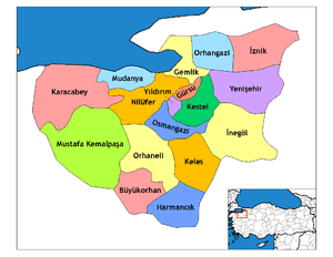
Yıldırım is a metropolitan district in the centre of Bursa in Turkey. The district was named after Ottoman Sultan Bayezid I. It was founded in 1987 and it has a size of 399 km². The Sultan Bayezid I's nickname was Yıldırım, which means thunderbolt in Turkish.
Location
Yıldırım, which is located at the foot of the Mt. Uludağ is 399 square kilometers (km²) and 150–155 metres in elevation. Kestel and Gürsu are located west of Yıldırım, and Demirtaş, a subdistrict of Osmangazi, lies to the north. South of Yıldırım is Mt. Uludağ and to the north are relatively flat lands. The Bursa-Ankara highway passes through the Yıldırım district.
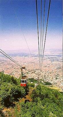
The Bursa Uludağ Aerial Lift, (Turkish: Teleferik, pictured to the right) is an aerial lift line serving Mt. Uludağ. Built initially by the Swiss company Von Roll Holding and opened on 29 October 1963, the aerial tramway was replaced in 2013 by a modern and much bigger capacity gondola lift system of Leitner Group from Italy.[3]
Management
The district Yıldırım with the Osmangazi and Nilüfer constitutes the Bursa metropolitan municipality. It has 66 quarters and a village called Cumalıkızık, where it is possible to examine the characteristics of Ottoman architecture. This settlement's historical architectural uniqueness has totally been preserved, and has made the Yıldırım sub-province famous. Concerning population, Yıldırım is bigger than many cities in Turkey. According to the 2000 census, it has a population of 629,702. 30% of Bursa's population lives in Yıldırım district.
Historical places
Yeşil Mosque (Green Mosque), Yeşil Türbe (Green Tomb), Bayezid I Mosque and complex (külliye) (Yıldırım Camii ve külliyesi), Emir Sultan Mosque and Cumalıkızık village.
References
- ↑ "Area of regions (including lakes), km²". Regional Statistics Database. Turkish Statistical Institute. 2002. Retrieved 2013-03-05.
- ↑ "Population of province/district centers and towns/villages by districts - 2012". Address Based Population Registration System (ABPRS) Database. Turkish Statistical Institute. Retrieved 2013-02-27.
- ↑ "Construction of the world's longest monocable gondola lift in Bursa". Leitner Ropeways. Retrieved 2013-11-08.