1979 Red River Valley tornado outbreak
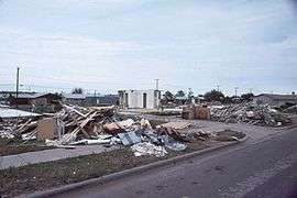 Destruction in Wichita Falls, Texas after the tornado | |
| Type | Tornado outbreak |
|---|---|
| Duration | April 10–11, 1979 |
| Tornadoes confirmed | 59 confirmed |
| Max rating1 | F4 tornado |
| Duration of tornado outbreak2 | 2 days |
| Damage | unknown |
| Casualties | 58 fatalities, approximately 100 injuries |
| Areas affected | Midwestern and Southern United States |
|
1Most severe tornado damage; see Fujita scale 2Time from first tornado to last tornado | |
The 1979 Red River Valley tornado outbreak was a tornado event that occurred on April 10, 1979 near the Red River Valley. It is noted for the F4 tornado that hit Wichita Falls, Texas and is commonly referred to as "Terrible Tuesday" by many meteorologists. Additional ones were reported across the Southern Plains as well as in the Mississippi River Valley on April 10–11, 1979.
Formation of the tornadoes
A deepening low pressure system formed in Colorado as a warm front lifted north pulling warm, moist, unstable air. There was strong upper level dynamics all coming together to produce strong tornado-producing supercells. In the early afternoon hours, three supercell thunderstorms formed. They moved northeastward, and as a trio spawned families of tornadoes. These supercells caused the most damaging tornadoes of the outbreak.
The first tornado formed near Crowell, Texas at around 3:05 p.m. About 35 minutes later, the first killer one of the outbreak ripped through Vernon and killed 11 people. Then the supercell spawned one that killed three people in Lawton, Oklahoma. The second supercell spawned one that moved 64 miles (103 km).
Wichita Falls,TX
The third supercell was the one that formed the Seymour and Wichita Falls tornadoes as part of a three-member tornado family. The first one formed near Seymour at around 4:53 pm. The storm spawned a second one and moved through the south and east sides of Wichita Falls at around 6:00 pm. The third member of the family formed near Waurika, Oklahoma at around 8:00 p.m.
The Wichita Falls tornado formed in Archer County and moved northeast and damaged a few rural homes and high voltage towers. It rapidly intensified as it entered the city near Memorial Stadium by McNiel Jr. High on Southwest Parkway, which was located to the west of Wichita Falls at approximately 6:07 p.m. damaging both structures severely. Hail the size of golf balls preceded the touchdown and continued for approximately 15 minutes. It then became calm before the winds began to pick up.
| State | Total | County | County total |
|---|---|---|---|
| Indiana | 1 | Warrick | 1 |
| Oklahoma | 3 | Comanche | 3 |
| Texas | 54 | Wichita | 42 |
| Wilbarger | 12 | ||
| Totals | 58 | ||
| All deaths were tornado-related, | |||
The massive wedge tornado, which was at its maximum 1.5 miles (2.4 km) wide, cut a 2.5-mile (4.0 km) swath of destruction through the south side of town, leveling everything in its path. It destroyed an apartment complex near the beginning of its path. It also took its first lives there. It later destroyed a restaurant, the majority of Sikes Senter, the major mall, and another apartment complex where it took more lives. Neighborhoods all along Southwest Parkway were leveled and nothing but debris and destruction remained.
A number of people tried to flee as the tornado moved along U.S. Highways 281 and 287. More people were killed in their cars. It then moved into Clay County and changed its appearance to display a multiple-vortex structure. There were at times 5 separate vortices visible within the tornado. It inflicted additional damage south of Dean and Byers, but no more fatalities occurred. It crossed into Oklahoma where additional damage occurred before it dissipated.
Damage
At the end of the outbreak, 54 people lost their lives in Texas, three were killed in Oklahoma and one was killed in Indiana. The Wichita Falls tornado alone killed 42 people and caused $400 million in damage. An 8 miles (13 km) swath of the city had significant devastation.
Confirmed tornadoes
| F0 | F1 | F2 | F3 | F4 | F5 | Total |
|---|---|---|---|---|---|---|
| 10 | 18 | 25 | 4 | 2 | 0 | 59 |
April 10 event
| F# | Location | County / Parish | State | Start Coord. | Time (UTC) | Path length | Max width | Summary | Refs |
|---|---|---|---|---|---|---|---|---|---|
| F0 | S of Crosbyton | Crosby | TX | 33°39′N 101°14′W / 33.65°N 101.23°W | 1908 | 2 miles (3.2 km) | [1][2] | ||
| F0 | E of Plainview | Hale | TX | 34°12′N 101°41′W / 34.20°N 101.68°W | 1938 | 0.1 miles (160 m) | [1][2] | ||
| F2 | SW of Foard City to S of Rayland | Foard | TX | 33°51′N 99°48′W / 33.85°N 99.80°W | 2105 | 22.1 miles (35.6 km) | Homes were unroofed and barns were destroyed. | [1][2] | |
| F4 | SE of Rayland, TX to NE of Davidson, OK | Foard (TX), Wilbarger (TX), Tillman (OK) | TX, OK | 34°02′N 99°28′W / 34.03°N 99.47°W | 2120 | 39.7 miles (63.9 km) | 11 deaths - Large wedge tornado struck the town of Vernon, where numerous homes and businesses were destroyed including a cafe, motel, and truck stop. 7 of the deaths occurred when vehicles were thrown from US-287. Tornado crossed into Oklahoma, destroying 3 homes and damaging 5 others. Caused $27,000,000 in damage and injured an additional 67 people. | [1][2] | |
| F0 | SE of Thalia | Foard | TX | 33°59′N 99°32′W / 33.98°N 99.53°W | 2120 | 2.5 miles (4.0 km) | [1][2] | ||
| F2 | Harrold, TX to Marlow, OK | Wilbarger (TX), Wichita (TX), Tillman (OK), Cotton (OK), Comanche (OK), Stephens (OK) | TX, OK | 34°05′N 99°02′W / 34.08°N 99.03°W | 2155 | 74.1 miles (119.3 km) | 1 death - Large wedge tornado moved through Texas and Oklahoma. Eight planes were destroyed at an airport near Grandfield, and a home in the area lost its exterior walls. A grain elevator was destroyed in the Hulen area, and homes were damaged in Pumpkin Center and near Walters. Fatality occurred when a woman took shelter underneath a semi-truck, which rolled over her when the tornado struck. | [1][2] | |
| F2 | N of Hollister | Tillman | OK | 34°21′N 98°54′W / 34.35°N 98.90°W | 2205 | 9.2 miles (14.8 km) | Three houses were destroyed and several others were damaged. | [1][2] | |
| F1 | N of Faxon | Comanche | OK | 34°28′N 98°37′W / 34.47°N 98.62°W | 2235 | 7.1 miles (11.4 km) | A mobile home was destroyed in the Faxson area, resulting in two serious injuries. Other homes in the area were damaged. Tornado left suction vortex marks in open fields. | [1][2] | |
| F2 | NE of Seymour | Baylor | TX | 33°37′N 99°18′W / 33.62°N 99.30°W | 2249 | 10.4 miles (16.7 km) | Tornado damaged roofs, telephone poles, trees, uprooted shrubs and overturned a truck, but remained over open country while at peak intensity. Tornado was well documented on film and by NSSL storm researchers. | [1][2] | |
| F3 | Lawton area | Comanche | OK | 34°34′N 98°25′W / 34.57°N 98.42°W | 2305 | 4.5 miles (7.2 km) | 3 deaths - Strong tornado struck Lawton, destroying over 116 structures, and damaging over 330 others. Unanchored homes were completely swept from their foundations. One of the fatalities occurred when a car was tossed from a road. | [1][2] | |
| F1 | SW of Iowa Park | Wichita | TX | 33°54′N 98°48′W / 33.90°N 98.80°W | 2308 | 0.1 miles (160 m) | [1][2] | ||
| F4 | SW of Wichita Falls to E of Waurika, OK | Archer (TX), Wichita (TX), Clay, Jefferson (OK) | TX, OK | 33°49′N 98°39′W / 33.82°N 98.65°W | 2350 | 46.9 miles (75.5 km) | 42 deaths - See section on this tornado | [1][2] | |
| F1 | Wichita Falls area | Wichita | TX | 33°54′N 98°30′W / 33.90°N 98.50°W | 0000 | 2 miles (3.2 km) | Second, much weaker tornado in the area. | [1][2] | |
| F2 | S of Noble | Cleveland | OK | 35°06′N 97°22′W / 35.10°N 97.37°W | 0040 | 2 miles (3.2 km) | Two barns were damaged. | [1][2] | |
| F2 | E of Bellemont | Pottawatomie, Lincoln | OK | 35°25′N 96°45′W / 35.42°N 96.75°W | 0045 | 4.6 miles (7.4 km) | Two trailers were destroyed, and three homes were damaged. One person was injured. | [1][2] | |
| F2 | SW of Noble | Cleveland | OK | 35°06′N 97°24′W / 35.10°N 97.40°W | 0050 | 1.5 miles (2.4 km) | A mobile home was destroyed. | [1][2] | |
| F1 | Hays area | Ellis | KS | 38°52′N 99°19′W / 38.87°N 99.32°W | 0130 | 0.5 miles (0.80 km) | 67 yd (61 m) | [1][2] | |
| F3 | W of Pruitt City | Carter | OK | 34°21′N 97°36′W / 34.35°N 97.60°W | 0155 | 12.8 miles (20.6 km) | Severe damage in the Pruitt City area. 44 homes and mobile homes were damaged or destroyed. Several vehicles, including a bus, were flipped and tossed. | [1][2] | |
| F0 | W of Oakland | Pottawatomie | OK | 34°07′N 96°48′W / 34.12°N 96.80°W | 0205 | 0.2 miles (320 m) | [1][2] | ||
| F2 | SW of Novice | Runnels, Coleman | TX | 31°58′N 99°48′W / 31.97°N 99.80°W | 0317 | 9.6 miles (15.4 km) | Large tornado destroyed several barns and scattered debris over a large area. | [1][2] | |
| F3 | SW of Talpa to N of Coleman | Runnels, Coleman | TX | 31°42′N 99°45′W / 31.70°N 99.75°W | 0330 | 25 miles (40 km) | Homes and barns were ripped apart. | [1][2] | |
| F1 | SE of Comanche | Comanche | TX | 31°52′N 98°31′W / 31.87°N 98.52°W | 0550 | 0.1 miles (160 m) | [1][2] | ||
| F2 | S of Energy to W of Hico | Comanche, Hamilton | TX | 31°45′N 98°22′W / 31.75°N 98.37°W | 0550 | 24 miles (39 km) | Barns were destroyed and homes sustained roof damage. A woman was injured when her truck rolled into the ditch in which she was taking cover. | [1][2] | |
| F1 | Mineral Wells area | Palo Pinto | TX | 32°48′N 98°07′W / 32.80°N 98.12°W | 0556 | 0.1 miles (160 m) | [1][2] | ||
April 11 event
| List of reported tornadoes - Wednesday, April 11, 1979 | |||||||
|---|---|---|---|---|---|---|---|
| | | | | | | | |
| Texas | |||||||
| F1 | NE of Southmayd | Grayson | 0206 | 0.1 miles (160 m) | |||
| F2 | N of Athens | Henderson, Van Zandt | 1610 | 13.3 miles (21.4 km) | |||
| F2 | Sulphur Springs area | Hopkins | 1612 | 8.3 miles (13.4 km) | |||
| F1 | NW of Hainesville | Wood | 1702 | 0.1 miles (160 m) | |||
| Oklahoma | |||||||
| F0 | N of Oakland | Pottawatomie | 0205 | 0.2 miles (320 m) | |||
| F1 | NE of Allen | Pontotoc | 0601 | 3 miles (4.8 km) | |||
| F2 | NW of Kingston | Marshall | 0705 | 0.1 miles (160 m) | A trailer and three barns were destroyed. | ||
| F0 | W of Beland | Muskogee | 1000 | 0.1 miles (160 m) | |||
| F2 | SW of Eagletown to W of Big Fork (AR) | McCurtain, Sevier (AR), Polk (AR) | 1715 | 42 miles (68 km) | 3 people were injured in a mobile home near the beginning of the path. Major damage in the Grannis area. Six homes, 19 trailers, and an elementary school were destroyed, where 4 students were injured. Two homes were also destroyed near Wickes. Tornado injured a total of 20 people and caused $1,750,000 in damage. | ||
| Arkansas | |||||||
| F2 | E of Hattieville | Conway | 1310 | 5.4 miles (8.7 km) | Six barns and two homes were destroyed. Other homes, barns, and outbuildings were damaged. | ||
| F1 | W of Mountain View | Stone | 1442 | 8.7 miles (14.0 km) | |||
| F2 | Prairie Grove area | Washington | 1602 | 11.1 miles (17.9 km) | |||
| F2 | NE of Bodcaw | Nevada | 2010 | 0.5 miles (0.80 km) | Three homes were destroyed and others were damaged. | ||
| F2 | SW of Guy | Faulkner | 2015 | 3 miles (4.8 km) | Several buildings were torn apart and a cemetery was damaged. Caused $190,000 in damage. | ||
| F2 | E of East End to NE of Lonoke | Saline, Pulaski, Lonoke | 2100 | 40.3 miles (64.9 km) | Several trailers were destroyed. Damage also occurred to machinery, homes and outbuildings. | ||
| F1 | NE of Fryatt | Fulton | 2145 | 0.5 miles (0.80 km) | |||
| F1 | W of Beebe | White | 2150 | 6.5 miles (10.5 km) | |||
| F2 | NE of Crossett | Ashley | 2210 | 10.4 miles (16.7 km) | Tornado caused $3,500,000 to the downtown business district in Hamburg. Second tornado to strike Hamburg in three days. | ||
| F2 | NW of Black Rock | Lawrence | 2235 | 2 miles (3.2 km) | Caused over $300,000 in damage to homes, barns, and a rock crushing plant. | ||
| F2 | E of McGehee | Desha | 2315 | 3.6 miles (5.8 km) | Homes and businesses were torn apart in the McGehee area. Caused a total of $449,000 in damage. | ||
| Missouri | |||||||
| F0 | W of Hurley | Stone | 1310 | 0.1 miles (160 m) | |||
| F3 | W of Sterling to E of Licking | Douglas, Texas | 1500 | 35.4 miles (57.0 km) | |||
| F0 | SW of Bakersfield | Ozark | 2115 | 2.7 miles (4.3 km) | |||
| F1 | NE of Libertyville | St. Francois, Ste. Genevieve | 2330 | 8.5 miles (13.7 km) | A concrete block building was destroyed, and another was partially destroyed. A home was badly damaged, losing a large portion of its front side. Two barns were also destroyed and scattered across a field. | ||
| F2 | Liberty to SE of Barnesville | Clay, Clinton | 0100 | 20.1 miles (32.3 km) | Several homes and businesses, a mobile home park, a church, and a school were damaged. Three barns were destroyed as well. 5 bus passengers were injured when they took shelter in a ditch, only to have the bus roll onto them. | ||
| Kansas | |||||||
| F1 | NW of Colby | Thomas | 2100 | 0.1 miles (160 m) | |||
| F1 | N of Topeka | Shawnee | 2300 | 4.1 miles (6.6 km) | |||
| Louisiana | |||||||
| F1 | SW of Homer | Claiborne | 2100 | 2 miles (3.2 km) | |||
| Nebraska | |||||||
| F0 | S of Sweetwater | Buffalo | 0000 | 0.5 miles (0.80 km) | |||
| Mississippi | |||||||
| F1 | NW of Roundaway | Coahoma | 0005 | 0.5 miles (0.80 km) | |||
| F2 | NE of Columbus | Lowndes | 0900 (04/12) | 7.7 miles (12.4 km) | |||
| Kentucky | |||||||
| F2 | S of Dycusburg to W of Bellville | Crittenden, Webster, Henderson | 0150 | 36 miles (58 km) | Tornado tore a large section of roof from an elementary school near Robards. 5 people were injured when trailers were overturned. | ||
| Indiana | |||||||
| F2 | SW of Boonville | Vanderburgh, Warrick | 0200 | 10 miles (16 km) | 1 death - Moved from the east side of Evansville to north of Boonville. A shopping center and a lumber yard were damaged. 1 person was killed and two others were injured when the tornado struck a mobile home park. | ||
| Tennessee | |||||||
| F0 | Dickson area | Dickson | 0500 | 0.3 miles (480 m) | |||
| Alabama | |||||||
| F1 | Florence area | Lauderdale | 0530 | 0.5 miles (0.80 km) | |||
| Source: Tornado History Project - April 11, 1979 Storm Data Grazulis (1977) | |||||||
See also
Notes
- ↑ All dates are based on the local time zone where the tornado touched down; however, all times are in Coordinated Universal Time for consistency.
References
- Fujita, T.T., and Wakimoto, R.M. (1979). "Red River Valley tornado outbreak of April 10, 1979", University of Chicago.
External links and sources
- The April 10, 1979 Severe Weather Outbreak by Don Burgess
- The Red River Valley Tornado Outbreak of April 10, 1979 (NWS Norman, OK)
- Full map of the 1979 Red River Valley tornado outbreak Tornado History Project
- A survivor's story (Joel Manes)
- 47miles.org - A project to construct a memorial to the Wichita Falls tornado
- The short film "Terrible Tuesday" is available for free download at the Internet Archive
| 10 costliest US tornadoes | ||||
|---|---|---|---|---|
| Rank | Area affected | Date | Damage 1 | Adjusted Damage 2 |
| 1 | Joplin, Missouri | May 22, 2011 | 2800 | 2950 |
| 2 | Tuscaloosa, Alabama | April 27, 2011 | 2450 | 2582 |
| 3 | Moore, Oklahoma | May 20, 2013 | 2000 | 2035 |
| 4 | Oklahoma City Metro, Oklahoma | May 3, 1999 | 1000 | 1422 |
| 5 | Hackleburg, Alabama | April 27, 2011 | 1290 | 1359 |
| 6 | Wichita Falls, Texas | April 10, 1979 | 400 | 1305 |
| 7 | Omaha, Nebraska | May 6, 1975 | 250 | 1100 |
| 8 | Washington, Illinois | November 17, 2013 | 935 | 951 |
| 9 | Lubbock, Texas | May 11, 1970 | 250 | 824 |
| 10 | Topeka, Kansas | June 8, 1966 | 250 | 729 |
| Source: Brooks, Harold E.; C. A. Doswell (Feb 2001). "Normalized Damage from Major Tornadoes in the United States: 1890–1999". Weather and Forecasting. American Meteorological Society. 16 (1): 168–76. doi:10.1175/1520-0434(2001)016<0168:NDFMTI>2.0.CO;2. 3 | ||||
|
1. These are the unadjusted damage totals in millions of US dollars. | ||||