Runnels County, Texas
| Runnels County, Texas | |
|---|---|
|
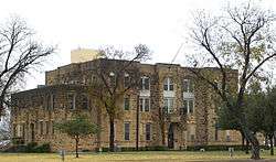
The Runnels County Courthouse in Ballinger | |
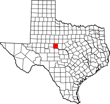 Location in the U.S. state of Texas | |
 Texas's location in the U.S. | |
| Founded | 1880 |
| Named for | Hiram G. Runnels |
| Seat | Ballinger |
| Largest city | Ballinger |
| Area | |
| • Total | 1,057 sq mi (2,738 km2) |
| • Land | 1,051 sq mi (2,722 km2) |
| • Water | 6.2 sq mi (16 km2), 0.6% |
| Population | |
| • (2010) | 10,501 |
| • Density | 10/sq mi (4/km²) |
| Congressional district | 11th |
| Time zone | Central: UTC-6/-5 |
| Website |
www |
Runnels County is a county located in the U.S. state of Texas. As of the 2010 census, its population was 10,501.[1] Its county seat is Ballinger.[2] The county was created in 1858 and later organized in 1880.[3] It is named for Hiram G. Runnels, a Texas state legislator.
History
- Original inhabitants are the Jumano, followed by the Comanche.[4]
- 1683–84 Juan Domínguez de Mendoza establishes a short-lived mission.[5]
- 1852 Fort Chadbourne established.[6]
- 1858 Runnels County, is formed from Bexar and Travis counties. It is named in honor of Hiram G. Runnels. Runnels City is the original county seat.[7]
- 1862 Pickettville established by Mr. and Mrs. John Guest and their three sons, also Henry and Robert K. Wylie and their cowboys and a black servant, and Mrs. Felicia Gordon and her five sons.[8] Ballinger settled by Richard Coffey and family.[9]
- 1880 The county is organized, with a population of 980.[4]
- 1888 Ballinger, namesake of William Pitt Ballinger is the new county seat.[9]
- 1889 The stone county courthouse is erected in the Second Empire style. Architect Eugene T. Heiner.[10]
- 1899 The community of Pumphrey, originally named New Hope, is established by Wm. M Pumphrey.[11]
- 1911 The Santa Fe Depot is built by the A,T,& SF Railroad. The Ballinger Carnegie Library in Ballinger is dedicated.[4]
- 1919 The Charles H. Noyes statue on the Ballinger Courthouse lawn, dedicated to the "Spirit of the Texas Cowboy", is sculptured by Pompeo Coppini.[12]
- 1927 MacMillan oil field, is discovered near Ballinger.[4]
- 1949 Eighteen new oil fields were explored.[4]
- 1987 The county beef cattle industry experiences an all-time high .[4]
Geography
According to the U.S. Census Bureau, the county has a total area of 1,057 square miles (2,740 km2), of which 1,051 square miles (2,720 km2) is land and 6.2 square miles (16 km2) (0.6%) is water.[13]
Major highways
Adjacent counties
- Taylor County (north)
- Coleman County (east)
- Concho County (south)
- Tom Green County (southwest)
- Coke County (west)
- Nolan County (northwest)
Demographics
| Historical population | |||
|---|---|---|---|
| Census | Pop. | %± | |
| 1880 | 980 | — | |
| 1890 | 3,193 | 225.8% | |
| 1900 | 5,379 | 68.5% | |
| 1910 | 20,858 | 287.8% | |
| 1920 | 17,074 | −18.1% | |
| 1930 | 21,821 | 27.8% | |
| 1940 | 18,903 | −13.4% | |
| 1950 | 16,771 | −11.3% | |
| 1960 | 15,016 | −10.5% | |
| 1970 | 12,108 | −19.4% | |
| 1980 | 11,872 | −1.9% | |
| 1990 | 11,294 | −4.9% | |
| 2000 | 11,495 | 1.8% | |
| 2010 | 10,501 | −8.6% | |
| Est. 2015 | 10,551 | [14] | 0.5% |
| U.S. Decennial Census[15] 1850–2010[16] 2010–2014[1] | |||
As of the census[17] of 2000, there were 11,495 people, 4,428 households, and 3,157 families residing in the county. The population density was 11 people per square mile (4/km²). There were 5,400 housing units at an average density of 5 per square mile (2/km²). The racial makeup of the county was 81.44% White, 1.40% Black or African American, 0.53% Native American, 0.32% Asian, 0.02% Pacific Islander, 14.31% from other races, and 1.98% from two or more races. 29.33% of the population were Hispanic or Latino of any race.
There were 4,428 households out of which 31.40% had children under the age of 18 living with them, 57.40% were married couples living together, 9.60% had a female householder with no husband present, and 28.70% were non-families. 26.70% of all households were made up of individuals and 15.70% had someone living alone who was 65 years of age or older. The average household size was 2.53 and the average family size was 3.06.
In the county, the population was spread out with 26.90% under the age of 18, 6.40% from 18 to 24, 24.20% from 25 to 44, 22.90% from 45 to 64, and 19.50% who were 65 years of age or older. The median age was 39 years. For every 100 females there were 92.90 males. For every 100 females age 18 and over, there were 87.10 males.
The median income for a household in the county was $27,806, and the median income for a family was $32,917. Males had a median income of $25,223 versus $18,988 for females. The per capita income for the county was $13,577. About 14.90% of families and 19.20% of the population were below the poverty line, including 25.10% of those under age 18 and 19.00% of those age 65 or over.
Communities
See also
References
- 1 2 "State & County QuickFacts". United States Census Bureau. Retrieved December 23, 2013.
- ↑ "Find a County". National Association of Counties. Retrieved 2011-06-07.
- ↑ "Texas: Individual County Chronologies". Texas Atlas of Historical County Boundaries. The Newberry Library. 2008. Retrieved May 26, 2015.
- 1 2 3 4 5 6 Pinkney, Katherine. "Runnels County, Texas". Handbook of Texas Online. Texas State Historical Association. Retrieved 30 November 2010.
- ↑ Hundell, Ken and Sharon (2005). Spirits of the Border V: The History and Mystery of the Lone Star State. Omega Press. p. 176. ISBN 978-0-9626087-9-7.
- ↑ Aston, B W; Taylor, Ira Donathon (1997). Along the Texas Forts Trail. University of North Texas Press. pp. 51–56. ISBN 978-1-57441-035-8.
- ↑ "Runnels City". Texas Escapes. Texas Escapes - Blueprints For Travel, LLC. Retrieved 30 November 2010.
- ↑ "Picketville". Texas Escapes. Texas Escapes - Blueprints For Travel, LLC. Retrieved 30 November 2010.
- 1 2 "Ballinger". Texas Escapes. Texas Escapes - Blueprints For Travel, LLC. Retrieved 30 November 2010.
- ↑ "Runnels County Courthouse". Texas Escapes. Texas Escapes - Blueprints For Travel, LLC. Retrieved 30 November 2010.
- ↑ "Pumphrey". Texas Escapes. Texas Escapes - Blueprints For Travel, LLC. Retrieved 30 November 2010.
- ↑ "The Charles H. Noyes Statue". Texas Escapes. Texas Escapes - Blueprints For Travel, LLC. Retrieved 30 November 2010.
- ↑ "2010 Census Gazetteer Files". United States Census Bureau. August 22, 2012. Retrieved May 9, 2015.
- ↑ "County Totals Dataset: Population, Population Change and Estimated Components of Population Change: April 1, 2010 to July 1, 2015". Retrieved July 2, 2016.
- ↑ "U.S. Decennial Census". United States Census Bureau. Retrieved May 9, 2015.
- ↑ "Texas Almanac: Population History of Counties from 1850–2010" (PDF). Texas Almanac. Retrieved May 9, 2015.
- ↑ "American FactFinder". United States Census Bureau. Retrieved 2011-05-14.
External links
- Runnels County government’s website
- Runnels County from the Handbook of Texas Online
 |
Nolan County | Taylor County | | |
| Coke County | |
Coleman County | ||
| ||||
| | ||||
| Tom Green County | Concho County |
Municipalities and communities of Runnels County, Texas, United States | ||
|---|---|---|
| Cities | | |
| Unincorporated communities | ||

Coordinates: 31°50′N 99°58′W / 31.83°N 99.97°W