Crittenden County, Kentucky
| Crittenden County, Kentucky | |
|---|---|
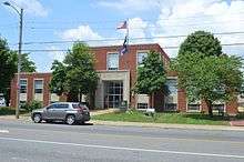 Crittenden County Courthouse in Marion | |
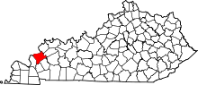 Location in the U.S. state of Kentucky | |
 Kentucky's location in the U.S. | |
| Founded | 1842 |
| Named for | John J. Crittenden |
| Seat | Marion |
| Largest city | Marion |
| Area | |
| • Total | 371 sq mi (961 km2) |
| • Land | 360 sq mi (932 km2) |
| • Water | 11 sq mi (28 km2), 3.0% |
| Population | |
| • (2010) | 9,315 |
| • Density | 26/sq mi (10/km²) |
| Congressional district | 1st |
| Time zone | Central: UTC-6/-5 |
| Website |
www |
Crittenden County is a county located in the U.S. state of Kentucky. At the 2010 census, the population was 9,315.[1] Its county seat is Marion.[2] The county was formed in 1842 and named for John J. Crittenden, senator and future Governor of Kentucky.[3][4] It is a prohibition or dry county.
History
Crittenden County, located on the Ohio and Tradewater Rivers in the Pennyroyal region of Kentucky, was created by the state legislature on April 1, 1842, from a portion of Livingston County. It became the state's 91st county, and was named for John J. Crittenden, a U.S. senator, attorney general, and governor of Kentucky. The first county seat was in Crooked Creek, but it was moved to Marion just two years later.
Crittenden County was once crossed by the Chickasaw Road, which was a part of the Old Saline Trace. This foot path was used by Native Americans when hunting game that crossed the Ohio River to the salt licks in Illinois. The first settler in the area was James Armstrong, who arrived from South Carolina in 1786 and built a log cabin. His family joined him five years later, along with other families that came to settle in the area. Early in the nineteenth century, Flynn's Ferry was established where the trail crossed the river.
Generally pro-Confederate during the American Civil War, the county saw little fighting, although both armies passed through it repeatedly. Several skimishes did place there, and the county courthouse was burned by Confederate Brigadier General Hylan B. Lyon during his raid across western Kentucky in December 1864. Lyon's men, all Kentuckians, burned a total of seven courthouses, since the Union Army was using them for barracks. The Confederates allowed the locals to remove the records before setting fire to the courthouses.[5]
Crittenden County has valuable deposits of fluorspar, zinc, porcelain, coal, limestone, and sand for making glass. Marion was primarily an industrial town in the 1840s associated with the large fluorspar mining industry. This industry peaked in 1947 and has been in slow decline since. Iron production was also a prominent industry in the mid-19th century, with several furnaces being built in the county, one owned by Andrew Jackson. Other products produced in the county include lumber, glass, modular homes, and blue crystal that was made famous by Ball canning jars. Today the county has a strong agricultural economy. In 1992, 66 percent of the population lived on farms, with 45 percent of the population reporting farming as their primary occupation.[5][6]
Geography
According to the U.S. Census Bureau, the county has a total area of 371 square miles (960 km2), of which 360 square miles (930 km2) is land and 11 square miles (28 km2) (3.0%) is water.[7] Its northwestern border with Illinois is formed by the Ohio River.
Major highways
 U.S. Route 60
 U.S. Route 641
 Kentucky Route 70
 Kentucky Route 91
 Kentucky Route 120
 Kentucky Route 295
Adjacent counties
- Union County (north)
- Webster County (northeast)
- Caldwell County (southeast)
- Lyon County (south)
- Livingston County (west)
- Hardin County, Illinois (northwest)
Demographics
| Historical population | |||
|---|---|---|---|
| Census | Pop. | %± | |
| 1850 | 6,351 | — | |
| 1860 | 8,796 | 38.5% | |
| 1870 | 9,381 | 6.7% | |
| 1880 | 11,688 | 24.6% | |
| 1890 | 13,119 | 12.2% | |
| 1900 | 15,191 | 15.8% | |
| 1910 | 13,296 | −12.5% | |
| 1920 | 13,125 | −1.3% | |
| 1930 | 11,931 | −9.1% | |
| 1940 | 12,115 | 1.5% | |
| 1950 | 10,818 | −10.7% | |
| 1960 | 8,648 | −20.1% | |
| 1970 | 8,493 | −1.8% | |
| 1980 | 9,207 | 8.4% | |
| 1990 | 9,196 | −0.1% | |
| 2000 | 9,384 | 2.0% | |
| 2010 | 9,315 | −0.7% | |
| Est. 2015 | 9,183 | [8] | −1.4% |
| U.S. Decennial Census[9] 1790-1960[10] 1900-1990[11] 1990-2000[12] 2010-2013[1] | |||
As of the census[13] of 2000, there were 9,384 people, 3,829 households, and 2,707 families residing in the county. The population density was 26 per square mile (10/km2). There were 4,410 housing units at an average density of 12 per square mile (4.6/km2). The racial makeup of the county was 98.24% White, 0.65% Black or African American, 0.15% Native American, 0.09% Asian, 0.14% from other races, and 0.74% from two or more races. 0.51% of the population were Hispanic or Latino of any race.
There were 3,829 households out of which 29.60% had children under the age of 18 living with them, 58.80% were married couples living together, 8.90% had a female householder with no husband present, and 29.30% were non-families. 27.00% of all households were made up of individuals and 13.80% had someone living alone who was 65 years of age or older. The average household size was 2.42 and the average family size was 2.93.
In the county the population was spread out with 23.20% under the age of 18, 8.00% from 18 to 24, 26.10% from 25 to 44, 26.40% from 45 to 64, and 16.30% who were 65 years of age or older. The median age was 40 years. For every 100 females there were 93.80 males. For every 100 females age 18 and over, there were 92.50 males.
The median income for a household in the county was $29,060, and the median income for a family was $36,462. Males had a median income of $30,509 versus $18,961 for females. The per capita income for the county was $15,262. About 14.70% of families and 19.10% of the population were below the poverty line, including 30.80% of those under age 18 and 15.70% of those age 65 or over.
Education
Students in Crittenden County attend Crittenden County Schools located in Marion.
Communities
Notable people
- Lee Cruce,attorney, second Governor of Oklahoma, Crittenden County native, Democratic Party (United States).
- William J. Deboe (June 30, 1849 – June 15, 1927), a Republican, was a U.S. Senator representing Kentucky from 1897 to 1903.
- Ollie M. James (July 27, 1871 – August 28, 1918), a Democrat, represented Kentucky in the United States House of Representatives from 1903 to 1913 and the United States Senate from 1913 to 1918.
- Walter Walker (1883-1932), a Democrat, was a United States Senator representing Colorado in 1932, and a newspaperman in Grand Junction, Colorado.
- Kenneth W. Winters, a Republican member of the Kentucky State Senate, was born in Crittenden County but resides in Murray, Kentucky.
- Forrest Pogue (1912-1996), eminent military historian, a combat historian in the US Army during World War II, author of the biography of General George C. Marshall, and Director of the George C. Marshall Foundation and library in Lexington, VA.
- Shelby Hearon(1931- ), author, recipient of fellowships from the Guggenheim Foundation, the National Endowment for the Arts, and the Ingram Merrill Foundation, winner of an American Academy of Arts and Letters Literature Award.
See also
References
- 1 2 "State & County QuickFacts". United States Census Bureau. Retrieved March 6, 2014.
- ↑ "Find a County". National Association of Counties. Archived from the original on May 31, 2011. Retrieved 2011-06-07.
- ↑ The Register of the Kentucky State Historical Society, Volume 1. Kentucky State Historical Society. 1903. p. 35.
- ↑ Gannett, Henry (1905). The Origin of Certain Place Names in the United States. Govt. Print. Off. p. 96.
- 1 2 Kleber, John E., ed. 1992, The Kentucky Encyclopedia. The University Press of Kentucky, Lexington.
- ↑ Hill, William 2014 "Phase I Archaeological Survey for the Planned Perry and Lisa Jones Wetland Reserve Enhancement Project, Crittenden County, Kentucky" Corn Island Archaeology, LLC. Louisville KY.
- ↑ "2010 Census Gazetteer Files". United States Census Bureau. August 22, 2012. Retrieved August 13, 2014.
- ↑ "County Totals Dataset: Population, Population Change and Estimated Components of Population Change: April 1, 2010 to July 1, 2015". Retrieved July 2, 2016.
- ↑ "U.S. Decennial Census". United States Census Bureau. Archived from the original on May 11, 2015. Retrieved August 13, 2014.
- ↑ "Historical Census Browser". University of Virginia Library. Retrieved August 13, 2014.
- ↑ "Population of Counties by Decennial Census: 1900 to 1990". United States Census Bureau. Retrieved August 13, 2014.
- ↑ "Census 2000 PHC-T-4. Ranking Tables for Counties: 1990 and 2000" (PDF). United States Census Bureau. Retrieved August 13, 2014.
- ↑ "American FactFinder". United States Census Bureau. Archived from the original on September 11, 2013. Retrieved 2008-01-31.
Municipalities and communities of Crittenden County, Kentucky, United States | ||
|---|---|---|
| Cities | | |
| CDPs | ||
| Other unincorporated communities | ||

Coordinates: 37°22′N 88°05′W / 37.36°N 88.09°W