November 17, 2013 tornado outbreak
 Storms associated with the outbreak over the Midwest United States on November 17 | |
| Type | Tornado outbreak |
|---|---|
| Duration | November 17, 2013 |
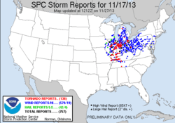
| Tornadoes confirmed | 73 confirmed, 136 reported |
| Max rating1 | EF4 tornado |
| Duration of tornado outbreak2 | 10 hours, 48 minutes |
| Highest winds |
|
| Largest hail | 4.00 in (10.2 cm) in diameter in Bloomington, IL |
| Damage | $1.6 billion[1] |
| Casualties | 8 fatalities (+3 non-tornadic); 190+ injuries (+2 indirect) |
| Areas affected | Midwest United States |
|
1Most severe tornado damage; see Enhanced Fujita scale 2Time from first tornado to last tornado | |
The November 17, 2013 tornado outbreak was the deadliest and costliest in the U.S. state of Illinois to occur in the month of November and fourth largest for the state overall.[2] Associated with a strong trough in the upper levels of the atmosphere, the event resulted in 73 tornadoes tracking across regions of the Midwest United States and Ohio River Valley, impacting seven states. Severe weather during the tornado outbreak caused over 100 injuries and eleven fatalities, of which eight were tornado related. Two tornadoes—both in Illinois and rated EF4 on the Enhanced Fujita Scale—were the strongest documented during the outbreak and combined for five deaths. In addition to tornadoes, the system associated with the outbreak produced sizeable hail peaking at 4.00 in (10.2 cm) in diameter in Bloomington, Illinois, as well as damaging winds estimated as strong as 100 mph (160 km/h) in three locations.
The development and progression of a severe weather event on November 17 had been well anticipated, and appeared in Storm Prediction Center products as early as November 12. The first storms associated with the event formed during the afternoon and evening hours of November 16 over the Great Plains, producing primarily hail and strong winds. However, tornadic activity was limited to November 17, as individual supercell thunderstorms tracked across the Midwest United States, at times producing long-tracked tornadoes. The first tornadoes formed over Illinois, while the final tornadoes developed over Tennessee. Towards the end of November 17, these individual systems had merged into an extensive squall line that tracked eastward across the Mid-Atlantic states, producing damaging wind before exiting into the Atlantic Ocean early on November 18.
With damage estimated at approximately $1.6 billion, the tornado outbreak became the seventh weather event and fifth tornado outbreak in the U.S. to accrue over $1 billion in damage that year. Tornadoes alone were responsible for $1.067 billion in damage, with the EF4 tornado that struck Washington, Illinois accounting for $935 million of the total. In addition to structural damage, widespread power outages affected thousands of electricity customers across the same regions impacted by the tornado outbreak and subsequent squall line.[3][4] Non-tornadic deaths and injured include one killed in Jackson County, Michigan, when a tree fell on a car, one killed by live wires in Shiawassee County, Michigan, one killed after touching a downed wire in Detroit, and two minor injuries in a home damaged by wind in Ohio.[5]
Meteorological synopsis and forecasts
Prior to November 17
Based on computer models, the Storm Prediction Center (SPC) began to assess the possibility of a widespread severe weather event for November 17 as early as November 12, though too much uncertainty existed at the time to delineate the probability and scale of the event.[6] As models gained a better consensus, the SPC later anticipated substantial increase in atmospheric instability along the periphery of a potential cold front, indicating the risk of damaging wind gusts and tornadoes.[7] Additional confidence over the next 24 hours resulted in a substantial expanding of this risk area into the lower Great Lakes on November 14, valid for Day 4. The overlap of increasing moisture in the atmosphere, wind shear, and high levels of CAPE were expected to contribute to the potential severe weather.[8] The development supercells and later squall lines was anticipated, and was also expected to impact the Mid-Atlantic states.[9] At around midday on November 15, the SPC issued a slight risk for severe weather for the 16th in regions concentrated primarily around Iowa and Missouri, forecasting the possibility of storms particularly during the evening to overnight hours of November 16.[10] The system associated with those storms was to track eastward and strengthen, and as a result the SPC also issued a Day 3 slight risk earlier on November 15 for a large swath of the Eastern United States in effect for November 17. The slight risk included a 30% chance of severe thunderstorm activity was forecast for an area concentrated on Indiana and Ohio.[10]
On November 16 at around 0700 UTC, the SPC upgraded their maximum convective outlook for the following day to a "moderate" for areas of the Ohio River Valley and the Great Lakes region on the basis of destabilizing atmospheric conditions, favorable wind shear, and an approaching shortwave trough.[11] The outlook was maintained for the 1730 UTC Day 2 update on November 16, but was also expanded to the west and a mention of the risk for strong tornadoes was added to the discussion. Isolated storms began to form during the afternoon hours of November 16 as the overall weather system swept across the West North Central region and into the East North Central region of the United States.[12] With development assisted by a dry line,[13] the storms did not produce any tornadoes, but caused strong winds in hail as large as softballs in northeastern Kansas.[14] The threat of additional severe activity that day was mitigated by cooling surface temperatures and marginal moisture and instability in the lower atmosphere.[15] By the end of the day, convection had moved closer to the Mississippi River, with the focus of intensifying storm activity shifting southeastwards to areas in and around the Ozark Plateau.[16]
November 17
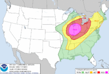
With the overall upper-level system expected to track eastward across the United States High Plains on November 17, the SPC issued a slight risk for severe thunderstorm activity for an area surrounding the confluence of the Mississippi and Missouri rivers, valid for the early morning hours of the day on November 17. Model data indicated the weakening of the capping inversion coinciding with increasing instability and wind shear, which would lead to the enhanced potential for storms and tornadoes as the night progressed and the low-level jet strengthened.[17] This overnight severe weather largely failed to develop, leading to only a very few isolated reports. However, at 0600 UTC on November 17, the SPC upgraded to a high risk for severe weather on the 17th (the second latest date in the year a high risk has been issued since 2000, and the latest in the Midwest) for a region of Illinois and Indiana in anticipation of conditions becoming increasingly favorable for a significant tornado outbreak;[18] this area of high risk was expanded at 1300 UTC to encompass a roughly circular region of the United States Midwest containing nearly 19 million people.[19] Those same regions were listed as having at least a 30% chance of tornadoes, coupled with a 45% chance for wind. The issuance of a high-risk zone reflected the anticipation of an intense upper-level trough and a strong mid-level jet stream producing highly conducive conditions for the development and prolonging of severe weather.[18]
The first signs of convection associated with the broad weather system began to form around dawn on November 17 over portions of Illinois, Iowa, and Missouri, triggered by a propagating cold front.[20] At 1440 UTC, the SPC issued a PDS tornado watch concentrated mostly around Illinois, citing the nearly certain likelihood for severe weather over the region.[21] Throughout the morning, discrete supercell thunderstorms developed ahead of the cold front across the length of Illinois;[22] their expected persistence eastward prompted the SPC to issue a second PDS tornado watch at 1621 UTC, this time for areas of Indiana, Michigan, and Ohio.[23] One of these storms would maintain a mesocyclone over a 50 mi (80 km) path.[24] The first tornado during the outbreak touched down 1652 UTC and tracked across Peoria and Tazewell counties in Illinois; the twister was later rated EF2.[25] This was followed shortly after by a long-tracked EF4 tornado, the strongest and costliest of the day, which tracked through multiple Illinois counties.[26]
By around 1730 UTC on November 17, the system associated with the tornado outbreak had become centered near Milwaukee, Wisconsin. As intense storm cells propagated across Illinois and Indiana, strong low-level wind shear in the vicinity of a warm front coupled with the weather system made areas as far north as Northern Michigan a viable environment for tornado development.[27][28] Numerous tornadoes touched down as a result of the supercells, several of which were strong to violent. In addition to spreading northward and eastward,[29] severe thunderstorms later spread southward into the Cairo, Illinois area and later Kentucky as a result of falling barometric pressures paving the way for the spread of moisture over the area. Additional significant tornadoes occurred in that area as well.[30][31] At around the same time, preexisting storms over Indiana and Illinois had begun to consolidate into a somewhat disorganized albeit extensive squall line.[29] As a result of the merging, the threat of tornadoes generally decreased slowly as the storms moved from Indiana into Ohio while the development of a major wind event seemed more apparent, particularly in Ohio. Despite the change in storm mode, additional strong tornadoes still occurred as far east as Western Ohio due to circulations embedded in the squall line.[29] This trend in severe weather also took place in other areas as clusters of isolated supercells began to coalesce into singular lines of storms.[32]
By the 0100 UTC update of the convective outlook on November 18, storms had cleared the high risk area from the previous outlooks. However, a moderate risk for severe weather was maintained across parts of central/eastern Ohio, western Pennsylvania, and western New York ahead of the rapidly moving convective system. In addition to a 45% probability of wind, up to a 10% probability of tornadoes was maintained, with the highest threat in central/eastern Ohio, although owing to extremely marginal surfaced based instability, only one or two further isolated tornadoes were reported in this area beyond 0100 UTC. By the late evening, most of the discrete storms that existed earlier in the day had merged into squall lines and bow echoes, with any remaining mesocyclones embedded within these bands rather than individual storms.[33] Forced along the extent of a cold front,[34] the primary squall line raced eastward across Ohio at approximately 60 mph (95 km/h), reaching Pennsylvania by 0200 UTC.[35] As a result of decreased atmospheric instability, the threat for tornadoes and hail had greatly diminished by this time, while the probability for damaging winds remained elevated to high; as a result, watches issued east of Ohio were severe thunderstorm watches rather than tornado watches.[36] The final tornado associated with the outbreak was an EF0 that dissipated at 0340 UTC in Lincoln County, Tennessee (south of the area impacted by the main outbreak of tornadoes); based on Central Standard Time, this would have still occurred on November 17.[37] By around 0800 UTC, the line of storms was quickly approaching the United States East Coast before entering the Atlantic Ocean.[38]
Confirmed tornadoes
| EF0 | EF1 | EF2 | EF3 | EF4 | EF5 | Total |
|---|---|---|---|---|---|---|
| 13 | 28 | 23 | 7 | 2 | 0 | 73 |
| EF# | Location | County / Parish | State | Coord. | Time (UTC) | Path length | Max width | Summary |
|---|---|---|---|---|---|---|---|---|
| EF2 | Pekin | Peoria, Tazewell | IL | 40°34′N 89°38′W / 40.57°N 89.63°W | 1652 – 1654 | 2.5 miles (4.0 km) | 100 yd (91 m) | Approximately 179 houses and 6 businesses suffered major damage (including some that lost their roofs), while 182 houses experienced minor roof damage. In addition, 3 apartment buildings lost their roofs, a power substation had minor damage, and hundreds of cars were damaged. Many trees and power lines were downed as well. 10 people were injured. This tornado was a precursor to the EF4 Washington tornado.[25][39][40] |
| EF4 | SE of East Peoria to E of Long Point | Tazewell, Woodford, LaSalle, Livingston | IL | 40°37′N 89°33′W / 40.62°N 89.55°W | 1659 – 1747 | 46.2 miles (74.4 km) | 0.5 mi (0.80 km) | 3 deaths – See section on this tornado |
| EF0 | NW of Litchfield | Macoupin, Montgomery | IL | 39°14′05″N 89°43′32″W / 39.2346°N 89.7255°W | 1730 – 1734 | 4 miles (6.4 km) | 50 yd (46 m) | There was photographic evidence of a large tornado; however, the tornado occurred over open fields, causing only minor damage to power poles, some trees, and a barn.[39][41][42] |
| EF0 | E of Dana to SSE of Long Point | LaSalle, Livingston | IL | 40°57′31″N 88°55′30″W / 40.9587°N 88.9251°W | 1743 – 1746 | 3 miles (4.8 km) | 50 yd (46 m) | Satellite tornado to the EF4 East Peoria/Washington tornado was caught on camera but caused no damage.[39][43] |
| EF1 | NNE of Breese | Clinton | IL | 38°42′35″N 89°31′03″W / 38.7097°N 89.5174°W | 1747 – 1748 | 0.4 miles (640 m) | 50 yd (46 m) | Brief tornado destroyed a garage and pole barn, removed shingles from a house, and snapped several trees.[39][41] |
| EF4 | SW of New Minden to NNE of Hoyleton | Washington | IL | 38°25′N 89°27′W / 38.42°N 89.45°W | 1804 – 1813 | 10.6 miles (17.1 km) | 200 yd (180 m) | 2 deaths – See section on this tornado |
| EF1 | NE of Hoyleton to SW of Centralia | Washington, Clinton | IL | 38°29′N 89°14′W / 38.48°N 89.24°W | 1814 – 1818 | 4.9 miles (7.9 km) | 100 yd (91 m) | Tornado formed immediately after the EF4 New Minden tornado had dissipated to the west. Multiple barns and outbuildings were either damaged or destroyed, a house sustained roof and chimney damage, a garage and a carport were damaged, a clubhouse at a ranch sustained major roof, siding, and window damage, and several trees were downed.[39][41] |
| EF1 | Northern Pana | Christian | IL | 39°23′51″N 89°04′43″W / 39.3974°N 89.0786°W | 1815 – 1818 | 2.5 miles (4.0 km) | 100 yd (91 m) | Tornado touched down on the north side of Pana, where several homes suffered roof and siding damage. Trees were blown down, damaging 3 cars. Power poles were also downed. As the tornado traveled north-northeast out of town, it damaged a home, destroyed an outbuilding, and downed trees and power lines before dissipating.[39][40][44] |
| EF2 | SW of St. Elmo to SSW of Altamont | Fayette, Effingham | IL | 38°59′47″N 88°55′44″W / 38.9965°N 88.9290°W | 1822 – 1832 | 11.5 miles (18.5 km) | 200 yd (180 m) | Tornado touched down southwest of St. Elmo, destroying a pole barn and scattering debris. It tracked northeast, damaging silos and either damaging or destroying numerous outbuildings. Three homes suffered significant damage, with two of the homes being moved off of their foundations. The tornado then destroyed a garage and two outbuildings and damaged several more outbuildings before moving into Effingham County and dissipating. Many trees were downed along the path.[39][40][41] |
| EF2 | SSW of Coal City to NNE of Wilmington | Grundy, Will | IL | 41°14′N 88°18′W / 41.24°N 88.30°W | 1822 – 1833 | 12.9 miles (20.8 km) | 200 yd (180 m) | Worst damage occurred in the Coal City/Diamond area. Many homes suffered varying degrees of damage, ranging from minor exterior damage to partial roof and wall loss. Several businesses were damaged, along with numerous RVs and other vehicles. A two story structure lost its roof and had portions of its walls ripped off. A model home was completely removed from its foundation on the north side of State Route 113. A manufactured building had its roof ripped off with all the walls collapsed. Several metal buildings were damaged and numerous trees and power lines were downed as well before the tornado dissipated. Five people were injured. This tornado formed from the same supercell that produced the Pekin and East Peoria/Washington tornadoes and it would go on to produce the Manhattan/Frankfort tornado.[39][43] |
| EF1 | ENE of West Liberty | Jasper | IL | 38°51′17″N 88°05′14″W / 38.8548°N 88.0872°W | 1825 – 1829 | 3.5 miles (5.6 km) | 100 yd (91 m) | Several homes suffered mainly roof and siding damage, but an older home lost its entire roof and had a collapse of two exterior walls. A semi trailer was turned over, at least four power poles were downed, and roofs were blown off of several barns, with at least one barn being destroyed. Numerous trees were downed along the path.[39][40] |
| EF0 | SW of Frohna | Perry | MO | 37°37′N 89°39′W / 37.62°N 89.65°W | 1826 | 150 yards (140 m) | 50 yd (46 m) | Very brief tornado downed several trees.[39][45] |
| EF1 | NE of Williamsburg to Garrett | Moultrie, Douglas | IL | 39°46′N 88°34′W / 39.77°N 88.56°W | 1830 – 1840 | 9.3 miles (15.0 km) | 0.25 mi (400 m) | In Moultrie County, major roof damage occurred to 8 homes, while 1 garage was destroyed and 17 outbuildings were severely damaged. Numerous trees and power poles were damaged as well. In Douglas County, the tornado damaged the roofs of 3 homes and 5 outbuildings, as well as numerous trees and power poles. Before dissipating, the tornado struck the town of Garrett, where the roofs of about two dozen homes and mobile homes were damaged.[39][40][46][47] |
| EF2 | SE of Manhattan to SSW of Frankfort | Will | IL | 41°25′N 87°56′W / 41.41°N 87.93°W | 1842 – 1848 | 5.5 miles (8.9 km) | 200 yd (180 m) | Several homes were damaged, five of which were subsequently deemed uninhabitable, along with several other structures, including two barns. Four high-tension power line towers were bent, and several other power lines and trees were downed. This tornado formed from the same supercell that produced the Pekin, East Peoria/Washington, and Coal City tornadoes.[39][43] |
| EF3 | NW of Tuscola to NNW of Broadlands | Douglas | IL | 39°50′N 88°17′W / 39.84°N 88.28°W | 1844 – 1900 | 18 miles (29 km) | 0.25 mi (400 m) | Tornado crossed Interstate 57, damaging multiple farms along the path. Numerous trees and power poles were downed, and a mobile home was destroyed with the undercarriage twisted. A large brick home had its entire second story ripped off, and multiple garages and outbuildings were destroyed. Several vehicles were damaged and tossed as well. This tornado absorbed the weaker Tuscola/Villa Grove tornado, which formed at 1845 UTC, while the two tornadoes were northeast of Villa Grove.[39][40] |
| EF1 | NNE of Tuscola to NW of Villa Grove | Douglas | IL | 39°50′N 88°17′W / 39.84°N 88.28°W | 1845 – 1850 | 5.2 miles (8.4 km) | 0.25 mi (400 m) | Tornado crossed Interstate 57, caused minor damage to two homes, and destroyed several outbuildings. The storm eventually merged with the more powerful EF3 Villa Grove/Broadlands tornado to the northwest of Villa Grove.[39][40] |
| EF3 | E of Thomasboro to SW of Wellington | Champaign, Vermillion, Iroquois | IL | 40°14′N 88°04′W / 40.24°N 88.06°W | 1845 – 1915 | 29.7 miles (47.8 km) | 0.5 mi (0.80 km) | Wedge tornado struck Gifford, where nearly 30 homes were destroyed, more than 40 suffered major damage, and around 125 had minor damage. Around 15 businesses sustained moderate to major damage and the roof of a school was peeled back. Hundreds of vehicles were damaged or destroyed as well. Some of the homes in Gifford were pushed off of their foundations, and many trees and power lines were downed as well. Tornado left cycloidal marks in farm fields outside of town, and damaged or destroyed several rural homes and farms. One unanchored home at a farm was leveled, and cinder blocks were found impaled into the side of a nearby truck. In Iroquois County, the tornado was only at EF0 strength, causing damage to outbuildings and downing trees. Six people suffered minor injuries. This was the first tornado to hit Iroquois County in November since reliable records began in 1950.[39][40][43][48] |
| EF1 | SE of Beecher | Kankakee, Will | IL | 41°18′N 87°33′W / 41.30°N 87.55°W | 1901 – 1902 | 0.8 miles (1.3 km) | 150 yd (140 m) | A large barn sustained significant roof and wall damage and two metal buildings lost part of their roofs, with debris being tossed almost 1,000 yards (910 m). A tractor blade weighing about 400 pounds (180 kg) was thrown 60 feet (18 m), a grain pipe was ripped from a silo and mangled, and several trees were downed.[39][43] |
| EF2 | NE of Allerton to NE of Westville | Vermillion | IL | 39°57′N 87°53′W / 39.95°N 87.88°W | 1903 – 1920 | 19.7 miles (31.7 km) | 0.25 mi (400 m) | Near Allerton, the tornado did major damage to 2 homes, caused roof damage to 4 other homes, and destroyed 9 outbuildings, 4 garages, and 2 grain bins. Numerous trees and power poles were also snapped. The tornado then passed north of Westville and impacted the villages of Hegeler and Belgium, where 9 homes sustained major damage, 26 had significant roof damage, and more than 100 had minor roof damage. The tornado also damaged more than 50 mobile homes, numerous garages and vehicles, and destroyed about 25 outbuildings in that area. One person was injured in the Hegeler/Belgium area before the tornado dissipated.[39][40][49] |
| EF1 | NE of Opdyke | Jefferson | IL | 38°16′N 88°47′W / 38.27°N 88.78°W | 1905 | Brief | 25 yd (23 m) | Brief tornado snapped several trees.[39][45] |
| EF3 | NW of Vanduser to NE of Blodgett | Scott | MO | 37°05′N 89°39′W / 37.08°N 89.65°W | 1907 – ? | 19 miles (31 km) | 600 yd (550 m) | Several site-built homes and mobile homes were either damaged or destroyed, with some of the site-built homes having complete roof loss and downed walls. Also, a shed and a garage were destroyed, three empty railroad cars were overturned, and several irrigation systems were blown around. A vehicle was blown out of the destroyed garage of one of the homes and damaged. Nine power poles and dozens of trees were downed as well.[39][45] |
| EF2 | Southwestern Sims to Northern Fairfield | Wayne | IL | 1908 – 1920 | 10 miles (16 km) | 150 yd (140 m) | A double-wide mobile home was destroyed, several other homes suffered mainly minor damage, and a building at a landfill was damaged. Several trees and power poles were downed as well.[39][45] | |
| EF0 | E of Wellington | Iroquois | IL | 40°31′42″N 87°40′09″W / 40.5283°N 87.6691°W | 1919 – 1923 | 4.6 miles (7.4 km) | 75 yd (69 m) | An outbuilding had its roof torn off and numerous trees were downed.[39][43] |
| EF2 | WSW of Rileysburg to W of Covington | Vermillion, Warren | IN | 40°08′43″N 87°26′08″W / 40.1453°N 87.4356°W | 1922 – 1926 | 6 miles (9.7 km) | 150 yd (140 m) | Tornado developed just inside the state line and moved northeast. A church was pushed off of its foundation and had exterior walls collapsed and a rail car was overturned in Rileysburg. A grain elevator in town was damaged as well. Trees were downed and a couple of mobile homes were destroyed west of Covington as well.[39][50][51] |
| EF1 | Goodland to NW of Remington | Newton, Jasper | IN | 40°45′42″N 87°17′51″W / 40.7616°N 87.2974°W | 1927 – 1932 | 5.6 miles (9.0 km) | 100 yd (91 m) | A large grain elevator was heavily damaged, an outbuilding was destroyed, and small farm equipment was moved, with one piece being rolled 50 feet (15 m) into a downed grain bin; debris was thrown about 1 mile (1.6 km) away from this area. Multiple trees were downed along the path. This was the first time in November and the latest during the calendar year that a tornado had been recorded in Newton County since reliable records began in 1950.[39][43] |
| EF2 | N of Albion | Wayne, Edwards | IL | 38°27′N 88°09′W / 38.45°N 88.15°W | 1930 – 1944 | 8 miles (13 km) | 300 yd (270 m) | An addition to a new home and an attached garage were destroyed, with two vehicles in the garage being turned around. Two 100-year-old barns were destroyed. Other residences had minor damage and several trees were downed.[39][45] |
| EF2 | Northern Veedersburg to NNE of Wingate | Fountain, Montgomery, Tippecanoe | IN | 40°06′59″N 87°14′44″W / 40.1163°N 87.2456°W | 1932 – 1945 | 12.8 miles (20.6 km) | 75 yd (69 m) | Tornado touched down in Veedersburg where there was roof damage to a large manufacturing plant. The most extensive damage with this tornado occurred in the town of Mellott, where a mobile home was completely destroyed and four others were either damaged or rolled off of their foundations. Elsewhere, an old business with a cinder-block base had its exterior walls collapsed, a barn and garage were destroyed, and the entire roof was removed from a home.[39][50][52] |
| EF2 | NNW of Albion | Wayne, Edwards | IL | 38°26′N 88°08′W / 38.44°N 88.14°W | 1933 – 1938 | 5 miles (8.0 km) | 100 yd (91 m) | This tornado touched down just south of the previous Albion event (with the tornadoes occurring simultaneously) and destroyed two machine sheds and a barn. Many trees were downed as well.[39][45] |
| EF2 | NW of Otterbein to WNW of Brookston | Benton, White | IN | 40°33′21″N 87°08′51″W / 40.5557°N 87.1475°W | 1940 – 1955 | 12.4 miles (20.0 km) | 1,400 yd (1,300 m) | In Benton County, the tornado heavily damaged an outbuilding, with debris being thrown 3 miles (4.8 km) downstream and wood beams from the building piercing the roof of a nearby garage. Another outbuilding was heavily damaged and multiple trees were downed. Moving into White County, it intensified and grew into a large multiple-vortex tornado, destroying 20 to 25 barns and scattering debris over 2 miles (3.2 km) away. Ten wooden power poles were snapped and a small home lost its roof, with debris being thrown and stuck into the ground. This was the first time in November and the latest during the calendar year that a tornado had been recorded in Benton County since reliable records began in 1950.[39][43][53] |
| EF2 | N of Bellmont to S of Allendale | Wabash | IL | 38°23′N 87°55′W / 38.38°N 87.91°W | 1944 – 1954 | 10 miles (16 km) | 225 yd (206 m) | Four site-built homes were damaged and two mobile homes were destroyed, one of which was thrown across a road and wrapped around a tree, injuring the occupant. One of the damaged homes lost part of its roof, a nearby garage was destroyed (although many of the contents were left unharmed), and several outbuildings were destroyed.[39][45][54] |
| EF0 | Bailey | Muskegon | MI | 43°16′N 85°52′W / 43.26°N 85.87°W | 1945 – ? | 0.6 miles (0.97 km) | <100 yd (91 m) | One of several weak tornadoes that touched down along a 50 mi (80 km) path through Michigan. Mostly tree damage was incurred but there was also damage to several buildings and fences.[39][55][56] |
| EF1 | SE of New Richmond to W of Linden | Montgomery | IN | 40°10′18″N 86°57′26″W / 40.1717°N 86.9571°W | 1947 – 1950 | 1.8 miles (2.9 km) | 40 yd (37 m) | The tornado hit two metal buildings near the Weaver Popcorn Plant, scattering metal debris, insulation, and wooden planks to the northeast.[39][50] |
| EF2 | NW of Romney to S of Lafayette | Tippecanoe | IN | 40°18′05″N 86°56′48″W / 40.3013°N 86.9467°W | 1950 – 1953 | 3.2 miles (5.1 km) | 75 yd (69 m) | An elementary and middle school both sustained significant damage, with roof damage to both and a wall blown out of the gymnasium at the middle school. Some homes sustained roof and structural damage, and a few trees were downed as well.[39][50][57] |
| EF1 | NE of Rensselaer to E of Gifford | Jasper | IN | 40°58′22″N 87°06′55″W / 40.9727°N 87.1152°W | 1950 – 2000 | 10.4 miles (16.7 km) | 100 yd (91 m) | Multiple grain bins and outbuildings were destroyed, with debris being strewn about 2 miles (3.2 km). Dozens of trees and several power poles were downed as well. This was the first November tornado in Jasper County since reliable records began in 1950.[39][43] |
| EF0 | South Raub | Tippecanoe | IN | 40°18′04″N 86°55′21″W / 40.3012°N 86.9224°W | 1951 – 1952 | 0.3 miles (480 m) | 50 yd (46 m) | A silo and small farm buildings were destroyed and many trees were downed.[39][50] |
| EF2 | NW of Chalmers | White | IN | 40°41′N 86°53′W / 40.69°N 86.88°W | 1951 – 1957 | 4.15 miles (6.68 km) | 300 yd (270 m) | Four power poles were snapped, roofing and siding was removed from a home, and two barns lost parts of their roofs. Another barn was destroyed, with debris being carried about 1 mile (1.6 km) to the northeast.[39][53] |
| EF3 | SSE of Lafayette to SE of Walton | Tippecanoe, Clinton, Carroll, Cass | IN | 40°20′46″N 86°50′03″W / 40.3462°N 86.8342°W | 1954 – 2027 | 39 miles (63 km) | 250 yd (230 m) | Strong, long-tracked tornado caused EF3 structural damage to a Voestalpine factory and a Subaru plant, both southeast of Lafayette. The tornado moved northeast out of Tippecanoe County, through Clinton County, and into Carroll County, downing trees and causing property damage in areas north of Dayton, northwest of Rossville, and southern and eastern Carroll County, where several buildings were damaged at a hog farm. The tornado moved into Cass County northwest of Young America and moved through the county at EF2 strength, causing extensive damage to several homes, destroying farm buildings, and downing trees and power lines before dissipating.[39][50][53][58] |
| EF1 | NW of Stockwell | Tippecanoe | IN | 40°17′15″N 86°48′38″W / 40.2875°N 86.8106°W | 1956 – 2000 | 2.9 miles (4.7 km) | 35 yd (32 m) | Two barns were damaged and a house sustained roof and siding damage, with debris being scattered considerable distances from all three structures.[39][50] |
| EF2 | WNW of Decker to SE of Vincennes | Knox | IN | 38°32′15″N 87°36′44″W / 38.5374°N 87.6121°W | 1956 – 2006 | 8.8 miles (14.2 km) | 100 yd (91 m) | A home had its second story removed and exterior walls collapsed north of Decker. Other homes sustained lesser damage, and tree damage occurred as well. Outbuildings were also damaged. One person was injured. The tornado dissipated just west of Monroe City.[39][50] |
| EF1 | Medaryville to NE of Denham | Pulaski | IN | 41°05′N 86°53′W / 41.08°N 86.89°W | 2003 – 2013 | 13.3 miles (21.4 km) | 100 yd (91 m) | A grain bin was blown off of its foundation and flattened, a center pivot was torn apart, and a large barn was destroyed. Several structures in Medaryville were damaged and numerous trees were downed as well. Twigs were also found speared into vinyl siding.[39][53] |
| EF3 | Woodville, KY to Brookport, IL to NW of Eddyville, KY | McCracken (KY), Massac (IL), Pope (IL), Livingston (KY), Lyon (KY) | KY, IL | 37°06′N 88°44′W / 37.10°N 88.74°W | 2005 – 2056 | 42 miles (68 km) | 500 yd (460 m) | 3 deaths – See section on this tornado |
| EF1 | NE of Monticello | White | IN | 40°49′N 86°36′W / 40.82°N 86.60°W | 2007 – 2008 | 0.8 miles (1.3 km) | 150 yd (140 m) | Four sections of a center pivot irrigation system were flipped, the roof and some walls were removed from a mobile home, and numerous trees were downed. A metal outbuilding was damaged as well.[39][53] |
| EF2 | Michigantown to N of Greentown | Clinton, Howard | IN | 40°19′34″N 86°23′41″W / 40.3262°N 86.3946°W | 2013 – 2036 | 25.8 miles (41.5 km) | 150 yd (140 m) | First of two tornadoes to strike Kokomo during the outbreak. A hog farm and several other properties were damaged northeast of Michigantown and east of Rossville. The tornado then moved into southern Kokomo, causing extensive damage to many homes, a bank, numerous fast food restaurants, and several other businesses. Vehicles were flipped and trees were snapped and uprooted as well.[39][50] |
| EF0 | SSW of Logansport | Cass | IN | 40°44′N 86°23′W / 40.74°N 86.38°W | 2020 – 2022 | 1.1 miles (1.8 km) | 150 yd (140 m) | A warehouse sustained minor roof damage, a house lost its roof, several other homes sustained minor damage, and several trees were downed. Impact to the house that lost its roof occurred on a sun room that had structural issues and aided in the wind being able to lift the roof of the house, preventing a higher rating. There was also damage in the southeast part of town; however, this was due to strong straight-line winds.[39][53][59] |
| EF2 | Washington | Daviess | IN | 38°38′31″N 87°13′21″W / 38.6420°N 87.2224°W | 2020 – 2023 | 2.8 miles (4.5 km) | 125 yd (114 m) | Tornado started to the west-southwest of Washington and moved into town, knocking a home off of its foundation and damaging over 100 other structures, including a tire shop and several other businesses. Detached garages were destroyed and trees were snapped and uprooted as well.[39][50][60][61] |
| EF1 | Southern Cassopolis | Cass | MI | 41°54′N 86°01′W / 41.90°N 86.01°W | 2027 – 2029 | 0.5 miles (0.80 km) | 50 yd (46 m) | The second story of a barn was destroyed, another barn lost its roof, and a garage was destroyed. Debris from the garage was scattered up to 500 yards away. Many trees were downed as well.[39][53][62] |
| EF2 | Southern Kokomo | Howard | IN | 40°27′50″N 86°07′36″W / 40.4639°N 86.1266°W | 2029 – 2030 | 0.5 miles (0.80 km) | 75 yd (69 m) | Second tornado to strike Kokomo during the outbreak. Touched down briefly in the southern part of the city, heavily damaging several well-built homes. A UAW building was damaged before the tornado lifted. In total, the two Kokomo tornadoes damaged or destroyed 300 homes. 30 businesses were damaged or destroyed as well. Five people were injured.[39][50][63] |
| EF1 | NE of Grissom Air Force Base | Miami | IN | 40°45′N 86°04′W / 40.75°N 86.07°W | 2030 – 2033 | 2.9 miles (4.7 km) | 250 yd (230 m) | Two hog barns lost their roofs, with one suffering collapsed walls. One part of the wall was thrown back into the rest of the barn, where it smashed the exhaust system. A mobile home's walls collapsed as well, with insulation scattered into a field. A billboard was blown over and a gas station's awning was damaged. Many trees were downed along the path as well[39][53] |
| EF2 | SW of Lebanon | Boone | IN | 40°01′03″N 86°32′02″W / 40.0176°N 86.5340°W | 2036 – 2042 | 3.7 miles (6.0 km) | 75 yd (69 m) | Tornado touched down southwest of Lebanon, damaged buildings in an industrial area, and crossed Interstate 65, flipping several cars and tractor-trailers. It then moved into the southern part of town, where a Starbucks was heavily damaged, along with multiple nearby homes. Two people were injured when their tractor-trailer was flipped at a truck stop in Lebanon.[39][50] |
| EF1 | ENE of Mentone | Kosciusko | IN | 2038 – 2040 | 1.1 miles (1.8 km) | 250 yd (230 m) | Two homes sustained significant roof damage, another home sustained roof, porch, and window damage, a barn was pushed off of its foundation and received structural damage, a metal shed had a wall blown out and roof damage, and a small outbuilding was lifted, with debris being carried up to 1 mile (1.6 km) away. Over 50 trees were downed along the path, most of which were downed in a stand near the end of the path.[39][53] | |
| EF3 | NW of Morganfield to E of Corydon | Union, Henderson | KY | 37°44′N 87°55′W / 37.74°N 87.91°W | 2041 – 2115 | 14.5 miles (23.3 km) | 200 yd (180 m) | A church roof was lifted and blown sideways, and frame homes sustained substantial structural damage. Many homes had roof damage as well, with one home losing its entire roof. Several barns and outbuildings were destroyed, some of which were large metal structures. A mobile home slid off its foundation, and another mobile home was disintegrated, with its undercarriage being thrown 50 yards (46 m) and little debris recovered from the site. The tops were blown off of grain bins, and a well-built home had a two-car garage ripped off, with roof, siding, and window damage to the rest of home. Metal was wrapped around trees, and many trees and power poles were downed.[39][45] |
| EF2 | SW of Sweetser to SE of La Fontaine | Grant, Wabash | IN | 2042 – 2052 | 12 miles (19 km) | 0.4 mi (640 m) | A hog barn sustained roof damage, a house lost a wall and part of its roof, and another house lost its entire roof. A garage was destroyed, and projectiles from the structure were found impaled into the roof of a nearby house. A two-story home had its top floor nearly removed. Multiple other homes sustained lesser damage, and tree damage also occurred. Dozens of vehicles were either damaged or destroyed as well.[39][53][64] | |
| EF2 | SE of Silver Lake | Wabash, Kosciusko | IN | 41°02′N 85°53′W / 41.04°N 85.89°W | 2043 – 2048 | 4.2 miles (6.8 km) | 150 yd (140 m) | Four farm buildings were completely destroyed, several cows were killed, and a two-story home lost part of its roof and had structural damage to a second-floor bedroom (the room was slightly shifted and a wall was buckled out). Power poles were snapped and trees were downed as well. Two people were injured, both by flying debris in the two-story house.[39][53] |
| EF1 | NE of Lebanon | Boone | IN | 40°04′38″N 86°22′30″W / 40.0771°N 86.3751°W | 2046 – 2050 | 3.7 miles (6.0 km) | 33 yd (30 m) | Damage was mainly limited to trees.[39][50][65] |
| EF1 | SE of Oswego | Kosciusko | IN | 41°18′N 85°48′W / 41.30°N 85.80°W | 2048 – 2050 | 1.7 miles (2.7 km) | 275 yd (251 m) | A center pivot irrigation system was damaged, seven power poles were either snapped or bent, a home suffered roof damage, and many trees were downed, a few of which fell onto a home and two vehicles.[39][53] |
| EF0 | S of Croton | Newaygo | MI | Unknown | Unknown | Unknown | One of several weak tornadoes that touched down along a 50 mi (80 km) path through Michigan. Mostly tree damage was incurred but there was also damage to several buildings and fences.[39][55][66] | |
| EF0 | S of Roseburg | Grant | IN | 40°31′N 85°43′W / 40.51°N 85.72°W | 2055 | Brief | Unknown | Brief tornado with no damage.[39][53] |
| EF1 | Northern Bedford | Lawrence | IN | 38°52′27″N 86°30′21″W / 38.8741°N 86.5057°W | 2057 – 2059 | 1.3 miles (2.1 km) | 50 yd (46 m) | Intermittent tornado tracked across the northern side of Bedford and caused roof and structural damage to several homes. Several trees and power lines were downed as well.[39][50] |
| EF1 | Atlanta | Hamilton, Tipton | IN | 40°12′40″N 86°01′58″W / 40.2111°N 86.0327°W | 2105 – 2108 | 1.9 miles (3.1 km) | 125 yd (114 m) | Numerous structures were damaged in Atlanta.[39][50] |
| EF1 | N of Princeton | Caldwell | KY | 37°07′N 87°53′W / 37.11°N 87.88°W | 2118 – ? | 4 miles (6.4 km) | 200 yd (180 m) | A large metal building had partial roof and wall loss, the front porch of a house was lifted up, and several houses and businesses had partial shingle loss. Dozens of trees were downed and several power poles were snapped as well.[39][45] |
| EF0 | S of Waters | Otsego | MI | 44°51′44″N 84°41′37″W / 44.8622°N 84.6936°W | 2127 – 2129 | 0.3 miles (480 m) | 150 yd (140 m) | Brief tornado touched down along Interstate 75, downing numerous poplar and evergreen trees.[39][67] |
| EF3 | SW of Nortonville to SE of White Plains | Hopkins | KY | 37°09′N 87°31′W / 37.15°N 87.51°W | 2132 – 2140 | 8 miles (13 km) | 200 yd (180 m) | Four homes were destroyed, including one double-wide mobile home. A dozen more homes had minor to moderate damage and several sheds and barns were destroyed. Hundreds of trees were downed as well. One person suffered minor injuries.[39][45] |
| EF0 | NW of Leslie | Ingham | MI | 42°29′N 84°28′W / 42.49°N 84.46°W | 2145 – 2147 | 0.25 miles (0.40 km) | 100 yd (91 m) | Brief tornado caused minor roof damage, tossed lawn furniture and deck steps, shifted a large shed, and heavily damaged a garage.[39][55] |
| EF1 | ESE of Scott | Van Wert | OH | 40°58′N 84°28′W / 40.97°N 84.46°W | 2147 – 2149 | 2 miles (3.2 km) | 150 yd (140 m) | A barn suffered extensive roof damage, including loss of trusses, while other barns sustained lesser roof damage. Trees were damaged, a horse trailer and some travel trailers were flipped, and some metal roofing was damaged near the end of the path.[39][53][68] |
| EF1 | SW of Greenville | Muhlenberg | KY | 37°11′N 87°23′W / 37.19°N 87.39°W | 2150 – ? | 0.9 miles (1.4 km) | 80 yd (73 m) | Fast-moving tornado tore parts of the roofs off of two mobile homes, buckled a door and blew out the side walls of a garage, and tore the roof and two walls off of a metal building. The roof of a patio was torn off and patio furniture was scattered over 100 yards (91 m) as well. Many trees were downed along the path.[39][45] |
| EF2 | NW of Ottoville to NE of Cloverdale | Paulding, Putnam | OH | 40°58′N 84°23′W / 40.96°N 84.39°W | 2152 – 2203 | 11.1 miles (17.9 km) | 440 yd (400 m) | In Paulding County, a barn sustained minor damage and a mobile home was shifted from its foundation. In Putnam County, two barns were damaged, with debris (including metal sheeting and wooden rafters) carried nearly a mile away. Several hay wagons were thrown as well. The tornado struck the town of Cloverdale before dissipating, where minor to moderate structural damage occurred, and many trees and power lines were downed. A church in town sustained extensive damage to its walls and roof, and a nearby home sustained collapse of a wall.[53][69][70][71] |
| EF1 | Huntsville | Butler | KY | 37°10′N 86°54′W / 37.16°N 86.90°W | 2210 – 2216 | 5.3 miles (8.5 km) | 200 yd (180 m) | Several site-built homes, mobile homes, and small outbuildings were suffered varying degrees of roof and wall damage and numerous trees were downed. One person was injured.[39][72][73] |
| EF1 | NW of North Baltimore to ENE of Jerry City | Wood | OH | 41°15′11″N 83°35′35″W / 41.253°N 83.593°W | 2232 – 2240 | 7 miles (11 km) | 100 yd (91 m) | Intermittent tornado either damaged or destroyed a few homes, damaged and overturned vehicles, and impaled wooden planks into the ground. Trees were downed as well.[39][74][75] |
| EF2 | Perrysburg to Oregon | Wood, Lucas | OH | 41°32′20″N 83°34′05″W / 41.539°N 83.568°W | 2235 – 2255 | 12 miles (19 km) | 200 yd (180 m) | Several homes, apartment buildings, and businesses were either damaged or destroyed. Gas station awnings and industrial buildings sustained major damage. Several vehicles were damaged and dozens of trees were downed as well.[39][74][76][77] |
| EF1 | E of Elmore | Ottawa | OH | 41°27′54″N 83°13′23″W / 41.465°N 83.223°W | 2300 – ? | 0.75 miles (1.21 km) | 75 yd (69 m) | A barn was destroyed, with debris being scattered through a field, and wood splinters were impaled into the ground.[39][74] |
| EF1 | SE of Orlinda | Robertson | TN | 36°35′N 86°40′W / 36.59°N 86.66°W | 2331 – 2332 | 1 mile (1.6 km) | 100 yd (91 m) | Several homes sustained roof and window damage and part of a wooden fence was blown down.[39][78] |
| EF0 | Northwestern Portland | Sumner | TN | 36°35′N 86°31′W / 36.59°N 86.52°W | 2341 – 2342 | 0.5 miles (0.80 km) | 50 yd (46 m) | The roof was blown off of a fire hall and into apartment buildings, causing mostly window damage. A few homes and a church sustained minor damage as well.[39][78] |
| EF0 | NW of Fayetteville | Lincoln | TN | 35°13′19″N 86°38′30″W / 35.2220°N 86.6418°W | 0337 – 0340 | 0.6 miles (0.97 km) | 25 yd (23 m) | The front porch of a home was lifted up, taking a large portion of metal roof with it. Debris was thrown about 50 yards (46 m). A two-story home sustained vinyl siding damage, a small wooden barn was lifted and thrown, and a piece of wood smashed into another house, leaving a hole. A carport was lifted and crushed and roofing was peeled off of a mobile home, with debris being strewn several hundred yards. Many trees were downed along the path, which was intermittent.[39][79] |
Notable tornadoes
East Peoria–Washington–Long Point, Illinois
Tracking 46.36 mi (74.61 km) across four counties in Illinois,[80] the EF4 tornado that caused major damage in Washington, Illinois was the strongest tornado documented in Illinois for the month of November since reliable records began in 1950.[43] Up until that point, two tornadoes in 1988 and 1991 were the strongest for that month.[81] The first tornado warning on the storm cell that produced the tornado was issued at 1650 UTC for portions of Peoria, Tazewell, and Woodford counties,[82] nine minutes before the tornado was estimated to have touched down.[26] By the time the tornado had developed, the tornado warning was still in effect for those areas, and at 1706 UTC, the Particularly Dangerous Situation wording was included into the tornado warning text.[82] Several tornado warnings were issued as the tornado tracked towards the northeast, with the final warning expiring at 1818 UTC, well after the tornado dissipated.[83]
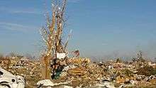
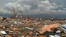
The tornado initially touched down at 1659 UTC roughly 2.4 mi (3.9 km) southeast of East Peoria in Tazewell County before moving directly into town. Damage was considerable in East Peoria, where the tornado accrued $110 million in damage costs. Thousands of trees and power poles were destroyed, along with 20 houses. Major damage was sustained by 75 houses, 7 businesses, and 5 apartment buildings, while 137 houses and 3 other businesses sustained minor damage. Four hundred vehicles were damaged in East Peoria. The tornado then strengthened and broadened to its peak intensity as a high-end EF4 with winds estimated at 190 mph (310 km/h) and a damage width extending 0.5 mi (0.80 km) in diameter as it moved into the nearby town of Washington.[26] A debris ball was detected on weather radar in association with the tornado as the storm moved over the city.[84] Entire neighborhoods in Washington were leveled, and some homes were swept clean from their foundations. The Georgetown Common Apartments were devastated by the tornado, and a pickup truck in the parking lot was found wrapped around a tree. Trees in Washington were denuded and partially debarked, and an auto parts store was completely leveled.[85] A total of 633 homes, 7 businesses, 7 apartment buildings, and 2,500 vehicles were destroyed in Washington, while minor to significant damage was sustained by numerous other structures. Though 5,000 people were in the path of the tornado, only one person was killed during the storm's initial passage, while two others died of injuries sustained during the tornado in the days following November 17. The low fatality count was attributed to people successfully seeking shelter. Damage costs in Washington amounted to $800 million. Alongside the three fatalities were 121 injuries throughout Tazewell County.[26]
The tornado then moved into Woodford County, where it maintained its size but slightly weakened to EF3 intensity as it passed near the towns of Roanoke, Benson, and Minonk. Despite tracking mostly across open fields, 70 farm buildings and 7 homes were destroyed, with major damage sustained to 17 homes. One unanchored farmhouse near Benson was swept away at EF3 intensity, and a car parked in the driveway was thrown into the basement.[85] Roughly 100 vehicles were damaged, including several semi-trucks at a truck stop north of Minonk, where three people were injured. Hundreds of power poles and trees were snapped, and a cell tower collapsed as well. Damage in Woodford County totaled $25 million.[86] The EF3 tornado weakened further to EF2 status as it briefly tracked over La Salle County, where damage totaled $150,000. Numerous power poles were snapped in this area, and two homes sustained significant damage. Various small outbuildings and a machine shed were also destroyed. Similar damage occurred in Livingston County, where in addition to outbuilding and power pole damage, an extensive swath of trees was sheared off, and a fire engine that was being stored in a garage was blown over as the structure was destroyed. The tornado finally dissipated 2 mi (3.2 km) east-northeast of Long Point at 1747 UTC, after remaining on the ground for 48 minutes.[87] In total, the tornado caused three fatalities and 125 injuries in two counties and $935.225 million in damage across four.[26]
New Minden, Illinois

At around noon on November 17, an EF4 tornado tracked across portions of Washington County, Illinois and resulted in the deaths of two people, becoming the second tornado that day to cause fatalities. The St. Louis, Missouri Weather Forecast Office first issued a tornado warning for areas of Clinton County and northern Washington County, Illinois at 1753 UTC, due to the tornadic threat of a rapidly moving severe thunderstorm in the region.[88] A tornado was estimated to have touched down 4.4 mi (7.1 km) southwest of New Minden near Interstate 64 at 1804 UTC, 11 minutes after the issuance of the initial tornado warning. A semi-trailer truck was blown off of the highway near this point, injuring the driver.[89] Just past the interstate, a farm home sustained EF1 damage and a man sustained minor cuts at that location. A nearby hay barn was destroyed at EF2 intensity.[90][91] The tornado rapidly intensified as it tracked northeastward, striking a small farm at mid-range EF4 intensity with maximum winds estimated to have been 180 mph (290 km/h).[92] The homestead there was completely swept away, and other buildings on the farm grounds sustained various degrees of damage. Several vehicles on the property were rolled as well. Two people were killed in the house as it was swept from its foundation.[89][90][91]
By 1807 UTC, the tornado continued through rural areas towards New Minden at EF2 strength, snapping power poles, destroying outbuildings, and removing much of the roof from a site-built home and a garage. A truck was overturned as well.[91] The tornado then struck the north side of New Minden directly,[91][92] inflicting significant damage to a church and several homes, two of which sustained EF3 damage with total roof loss and collapse of exterior walls. East of New Minden, a farm sustained EF2 damage, where outbuildings were completely destroyed and the farmhouse was shifted from its foundation. Trees were snapped and a grain bin was destroyed in this area as well. Moderate damage continued as the tornado crossed through rural areas northwest of Hoyleton. A mobile home 2 mi (3.2 km) north of Hoyleton was completely destroyed at EF2 intensity and a nearby outbuilding was damaged before the tornado dissipated at 1813 UTC, 2.6 mi (4.2 km) north-northeast of Hoyleton.[89] In total, the twister, which peaked at EF4 intensity, lasted for nine minutes and tracked across 10.59 mi (17.04 km).[93] Though initial damage surveys suggested a much longer damage path associated with one tornado, the damage was later reassessed to indicate the existence of two separate albeit consecutive tornadoes,[92] with the EF4 followed by an EF1 tornado that lasted for five minutes and had a path 4.76 mi (7.66 km) long.[90][94] The tornado warning for Washington and Clinton counties expired at 1830 UTC, after both tornadoes dissipated.[92]
Paducah, Kentucky/Brookport–Shady Grove–Unionville, Illinois

The final killer tornado of the outbreak was a long-tracked, heavily rain-wrapped EF3 that moved along the Ohio River through parts of Kentucky and Illinois and devastated the small town of Brookport, along with nearby rural communities.[45][95]
The tornado initially touched down just inside western McCracken County, Kentucky and moved across the northern fringes of Paducah. The tornado was at EF2 strength in McCracken County, demolishing an abandoned mobile home, causing roof and siding damage to many structures (most of them being homes), destroying the foyer of a church, bending road signs, ripping a wooden fence out of the ground, and blowing over chain-link fences. At one building, three metal roll-up doors were blown in and part of a wall was blown out. The tops of three steel power transmission towers were bent over, power lines were downed, train car covers were blown off, and a sports utility vehicle was blown 30 yards (27 m) into a ditch as well. Some damage to buildings and cooling towers at the Paducah Gaseous Diffusion Plant was noted, though no hazardous materials were released. The tornado crossed the Ohio River into Massac County, Illinois where it went through Brookport at low-end EF3 strength and completely destroyed dozens of mobile homes, many of which were blown over 100 feet (30 m). Also in Brookport, a frail site-built home was leveled, and dozens of homes, garages, storage buildings, and businesses sustained structural damage. Hundreds of trees were downed and cars were tossed as well. The tornado caused some minor damage to guard rails on the Ohio River bridge that carries traffic from Paducah to Brookport on U.S. Highway 45. East of Brookport, the tornado maintained EF3 strength as it impacted the small rural community of Shady Grove. Mobile homes in Shady Grove were obliterated, with their frames wrapped around trees. An empty school bus was picked up and thrown, and a two-story home was pushed off of its foundation and had many of its first floor walls ripped off, along with its porch. Past Shady Grove, the tornado struck the neighboring community of Unionville, where additional low-end EF3 damage occurred. Many trees in Unionville were snapped, and a large double-wide mobile home was obliterated and swept away, with debris scattered 500 feet. The home's heavy 7-by-12 foot concrete porch slab was lifted and moved by the tornado. The tornado weakened to EF2 strength as it moved briefly through Pope County and then back across the Ohio River into Livingston County, destroying several mobile homes and barns in this area and snapping numerous trees. In Lyon County, the tornado downed additional trees before dissipating. Three people were killed and 33 additional people were injured along the tornado's 42-mile long path. All fatalities occurred in mobile homes that were destroyed in Brookport. Snow that fell in the area during the days following the tornado hindered cleanup efforts.[39][45][90][95]
Non-tornadic events
The same system that contributed to the development of multiple tornadoes over several states also produced strong winds. On November 17, the SPC received 579 severe wind reports, of which 19 indicated winds exceeding 75 mph (120 km/h), the threshold for hurricane-force winds on the Beaufort scale. The strongest of these reported winds peaked at 100 mph (160 km/h) in three locations – Crown Point, Indiana, Swayzee, Indiana. West of Chicago in Ogle County, Illinois, six trucks were overturned on highways.[96] Much of Ohio was affected by straight-line winds, which caused widespread tree damage and sparked a power outage which impacted thousands of electricity customers. FirstEnergy reported a loss of electricity to 24,000 people in northwestern Ohio, with outages spiking in Wood County. Similarly, American Electric Power and Consumers Energy reported significant power outages, with the former indicating that at one point 33,500 of their customers were without service.[97] Outages were more widespread in Michigan, with blackouts under the purview of DTE Energy and Consumers Energy impacting 458,900 homes and businesses.[98] Across Indiana, over 160,000 people were without power. In Kokomo, Indiana, a mall, bank, and fire station all suffered considerable damage from tornadoes, and city management declared a state of emergency for the city and closed schools on November 18 following the storms.[96]
See also
- List of North American tornadoes and tornado outbreaks
- Tornadoes of 2013
- Great Blue Norther of November 11, 1911
- 2002 Veterans Day Weekend tornado outbreak
- Mid-November 2005 tornado outbreak
Notes
- ↑ All dates are based on the local time zone where the tornado touched down; however, all times are in Coordinated Universal Time for consistency.
References
- ↑ November 2013 Global Catastrophe Recap. Impact Forecasting (Report). AON Benefield. Archived from the original (PDF) on December 29, 2013. Retrieved 29 December 2013.
- ↑ Dr. Jeff Masters (November 18, 2013). "Rare November Tornado Outbreak Kills 6; Subtropical Storm Melissa Forms". Weather Underground. Weather Underground. Retrieved November 18, 2013.
- ↑ Ted Rowlands; Michael Pearson; Holly Yan (November 18, 2013). "Midwest tornadoes: 'The sky was just rumbling'". CNN. CNN. Retrieved November 18, 2013.
- ↑ Sharon Harris (November 17, 2013). "Emergency responders kept busy". Pekin Daily Times. Pekin Daily Times. Retrieved November 18, 2013.
- ↑ "State-by-state look at unusually large, late-season storm as it sweeps through Midwest". Associated Press. The Washington Post. November 18, 2013. Retrieved November 18, 2013.
- ↑ Kerr, Brynn (November 12, 2013). Day 4-8 Severe Weather Outlook Issued on Nov 12, 2013. Storm Prediction Center (Report). Norman, Oklahoma: National Oceanic and Atmospheric Administration. Retrieved March 8, 2014.
- ↑ Kerr, Brynn (November 13, 2013). Day 4-8 Severe Weather Outlook Issued on Nov 13, 2013. Storm Prediction Center (Report). Norman, Oklahoma: National Oceanic and Atmospheric Administration. Retrieved March 8, 2014.
- ↑ Kerr, Brynn (November 14, 2013). "Nov 14, 2013 0830 UTC Day 3 Severe Thunderstorm Outlook". Storm Prediction Center Convective Outlook. Norman, Oklahoma: Storm Prediction Center. Retrieved 8 March 2014.
- ↑ Kerr, Brynn (November 14, 2013). "Day 4-8 Severe Weather Outlook Issued on Nov 14, 2013". Storm Prediction Center Convective Outlook. Norman, Oklahoma: Storm Prediction Center. Retrieved 10 March 2014.
- 1 2 Guyer, Jared L. (November 15, 2013). "Nov 15, 2013 1730 UTC Day 2 Convective Outlook". Storm Prediction Center Convective Outlook. Norman, Oklahoma: Storm Prediction Center. Retrieved 10 March 2014.
- ↑ Dial, Greg L. (November 16, 2013). "Nov 16, 2013 0700 UTC Day 2 Convective Outlook". Storm Prediction Center Convective Outlook. Norman, Oklahoma: Storm Prediction Center. Retrieved 10 March 2014.
- ↑ Mead, Corey M. (November 16, 2013). "Mesoscale Discussion 2006". Storm Prediction Center Mesoscale Discussion. Norman, Oklahoma: Storm Prediction Center. Retrieved 10 March 2014.
- ↑ Rogers, Jaret W. (November 16, 2013). "Mesoscale Discussion 2007". Storm Prediction Center Mesoscale Discussion. Norman, Oklahoma: Storm Prediction Center. Retrieved 10 March 2014.
- ↑ "20131116's Storm Reports (1200 UTC - 1159 UTC)". Storm Prediction Center Local Storm Reports. Norman, Oklahoma: Storm Prediction Center. November 16, 2013. Retrieved 10 March 2014.
- ↑ Thompson, Richard L. (November 16, 2013). "Severe Thunderstorm Watch 560". Storm Prediction Center Weather Watches. Norman, Oklahoma: Storm Prediction Center. Retrieved 22 March 2014.
- ↑ Rogers, Jaret W.; Thompson, Richard L. (November 17, 2013). "Mesoscale Discussion 2008". Storm Prediction Center Mesoscale Discussion. Norman, Oklahoma: Storm Prediction Center. Retrieved 10 March 2014.
- ↑ Broyles, Chris (November 17, 2013). "Nov 17, 2013 0100 UTC Day 1 Convective Outlook". Storm Prediction Center Convective Outlook. Norman, Oklahoma: Storm Prediction Center. Retrieved 22 March 2014.
- 1 2 Broyles, Chris; Bunting, Bill (November 17, 2013). "Nov 17, 2013 0600 UTC Day 1 Convective Outlook". Storm Prediction Center Convective Outlook. Norman, Oklahoma: Storm Prediction Center. Retrieved 22 March 2014.
- ↑ Corfidi, Stephen F.; Peters, Jeffrey (November 17, 2013). "Nov 17, 2013 1300 UTC Day 1 Convective Outlook". Storm Prediction Center Convective Outlook. Norman, Oklahoma: Storm Prediction Center. Retrieved 22 March 2014.
- ↑ Peters, Jeffrey; Corfidi, Stephen F. (November 17, 2013). "Mesoscale Discussion 2010". Storm Prediction Center Mesoscale Discussion. Norman, Oklahoma: Storm Prediction Center. Retrieved 22 March 2014.
- ↑ Mead, Corey M. (November 17, 2013). "Particularly Dangerous Situation (PDS) Tornado Watch 561". Storm Prediction Center Weather Watches. Norman, Oklahoma: Storm Prediction Center. Retrieved 22 March 2014.
- ↑ Grams, Jeremy S. (November 17, 2013). "Mesoscale Discussion 2013". Storm Prediction Center Mesoscale Discussion. Norman, Oklahoma: Storm Prediction Center. Retrieved 22 March 2014.
- ↑ Mead, Corey M. (November 17, 2013). "Particularly Dangerous Situation (PDS) Tornado Watch 562". Storm Prediction Center Weather Watches. Norman, Oklahoma: Storm Prediction Center. Retrieved 22 March 2014.
- ↑ Grams, Jeremy S. (November 17, 2013). "Mesoscale Discussion 2015". Storm Prediction Center Mesoscale Discussion. Norman, Oklahoma: Storm Prediction Center. Retrieved 22 March 2014.
- 1 2 "Storm Events Database". NCDC. NCDC. Retrieved February 25, 2014.
- 1 2 3 4 5 "Storm Events Database". NCDC. NCDC. Retrieved February 27, 2014.
- ↑ Mead, Corey M. (November 17, 2013). "Tornado Watch 564". Storm Prediction Center Weather Watches. Norman, Oklahoma: Storm Prediction Center. Retrieved 22 March 2014.
- ↑ Grams, Jeremy S.; Mead, Corey M. (November 17, 2013). "Mesoscale Discussion 2014". Storm Prediction Center Mesoscale Discussion. Norman, Oklahoma: Storm Prediction Center. Retrieved 22 March 2014.
- 1 2 3 Mead, Corey M. (November 17, 2013). "Mesoscale Discussion 2018". Storm Prediction Center Mesoscale Discussion. Norman, Oklahoma: Storm Prediction Center. Retrieved 22 March 2014.
- ↑ Cohen, Ariel E. (November 17, 2013). "Mesoscale Discussion 2017". Storm Prediction Center Mesoscale Discussion. Norman, Oklahoma: Storm Prediction Center. Retrieved 22 March 2014.
- ↑ Mead, Corey M. (November 17, 2013). "Tornado Watch 565". Storm Prediction Center Weather Watches. Norman, Oklahoma: Storm Prediction Center. Retrieved 22 March 2014.
- ↑ Smith, Bryan T.; Thompson, Richard L. (November 17, 2013). "Mesoscale Discussion 2025". Storm Prediction Center Mesoscale Discussion. Norman, Oklahoma: Storm Prediction Center. Retrieved 22 March 2014.
- ↑ Smith, Bryan T. (November 18, 2013). "Mesoscale Discussion 2026". Storm Prediction Center Mesoscale Discussion. Norman, Oklahoma: Storm Prediction Center. Retrieved 22 March 2014.
- ↑ Thompson, Richard L. (November 18, 2013). "Severe Thunderstorm Watch 569". Storm Prediction Center Weather Watches. Norman, Oklahoma: Storm Prediction Center. Retrieved 22 March 2014.
- ↑ Rogers, Jaret W.; Thompson, Richard L. (November 18, 2013). "Mesoscale Discussion 2027". Storm Prediction Center Mesoscale Discussion. Norman, Oklahoma: Storm Prediction Center. Retrieved 22 March 2014.
- ↑ Thompson, Richard L. (November 18, 2013). "Severe Thunderstorm Watch 570". Storm Prediction Center Weather Watches. Norman, Oklahoma: Storm Prediction Center. Retrieved 22 March 2014.
- ↑ "Severe Weather Event on November 17, 2013". National Weather Service Office in Huntsville, Tennessee. National Oceanic and Atmospheric Administration. November 19, 2013. Retrieved November 19, 2013.
- ↑ Corfidi, Stephen F. (November 18, 2013). "Severe Thunderstorm Watch 574". Storm Prediction Center Weather Watches. Norman, Oklahoma: Storm Prediction Center. Retrieved 22 March 2014.
- 1 2 3 4 5 6 7 8 9 10 11 12 13 14 15 16 17 18 19 20 21 22 23 24 25 26 27 28 29 30 31 32 33 34 35 36 37 38 39 40 41 42 43 44 45 46 47 48 49 50 51 52 53 54 55 56 57 58 59 60 61 62 63 64 65 66 67 68 69 70 "131117's Storm Reports (1200 UTC - 1159 UTC)". Storm Prediction Center. National Oceanic and Atmospheric Administration. November 17, 2013. Retrieved November 17, 2013.
- 1 2 3 4 5 6 7 8 9 "Tornado Outbreak of November 17, 2013". National Weather Service Office in Lincoln, Illinois. NOAA, National Weather Service. November 19, 2013. Retrieved 21 August 2016.
- 1 2 3 4 "Fall Season Tornado Outbreak Sunday, November 17, 2013". National Weather Service Office in St. Louis, Missouri. National Oceanic and Atmospheric Administration. November 28, 2013. Retrieved December 21, 2013.
- ↑ "Storm Events Database". NCDC. NCDC. Retrieved February 27, 2014.
- 1 2 3 4 5 6 7 8 9 10 Chicago, Illinois Weather Forecast Office (December 4, 2013). "November 17th, 2013 Tornado Outbreak". Chicago, Illinois: NOAA, National Weather Service. Retrieved 21 August 2016.
- ↑ "Storm Events Database". NCDC. NCDC. Retrieved February 27, 2014.
- 1 2 3 4 5 6 7 8 9 10 11 12 13 "Damage Surveys for 11/17 Tornado Outbreak". National Weather Service Office in Paducah, Kentucky. National Oceanic and Atmospheric Administration. November 22, 2013. Retrieved November 25, 2013.
- ↑ "Storm Events Database". NCDC. NCDC. Retrieved February 27, 2014.
- ↑ "Storm Events Database". NCDC. NCDC. Retrieved February 27, 2014.
- ↑ "Storm Events Database". NCDC. NCDC. Retrieved February 27, 2014.
- ↑ "Storm Events Database". NCDC. NCDC. Retrieved February 27, 2014.
- 1 2 3 4 5 6 7 8 9 10 11 12 13 14 15 "Severe Weather and Tornado Outbreak of November 17, 2013". National Weather Service Office in Indianapolis, Indiana. National Oceanic and Atmospheric Administration. November 22, 2013. Retrieved November 23, 2013.
- ↑ "Storm Events Database". NCDC. NCDC. Retrieved February 27, 2014.
- ↑ "Storm Events Database". NCDC. NCDC. Retrieved February 27, 2014.
- 1 2 3 4 5 6 7 8 9 10 11 12 13 14 15 "November 17th, 2013 Severe Weather Outbreak". National Weather Service Office in Syracuse, Indiana. National Oceanic and Atmospheric Administration. November 19, 2013. Retrieved November 20, 2013.
- ↑ "Storm Events Database". NCDC. NCDC. Retrieved February 27, 2014.
- 1 2 3 "November 17, 2013 Severe Weather". National Weather Service Office in Grand Rapids, Michigan. National Oceanic and Atmospheric Administration. November 21, 2013. Retrieved December 21, 2013.
- ↑ "Storm Events Database". NCDC. NCDC. Retrieved February 27, 2014.
- ↑ "Storm Events Database". NCDC. NCDC. Retrieved February 27, 2014.
- ↑ "Storm Events Database". NCDC. NCDC. Retrieved February 27, 2014.
- ↑ "Storm Events Database". NCDC. NCDC. Retrieved February 27, 2014.
- ↑ Hren, Joe (November 19, 2013). "Tornado Damage Slideshow: Washington, Indiana". Indiana Public Media. Retrieved November 22, 2013.
- ↑ "Governor Pence Visits Washington". WBIW. November 19, 2013. Retrieved November 22, 2013.
- ↑ "Storm Events Database". NCDC. NCDC. Retrieved February 27, 2014.
- ↑ Kelly, Anne (November 20, 2013). "Community gathers to keep 'Kokomo strong' after weekend tornadoes". RTV6. Indianapolis, Indiana: RTV6. Retrieved November 22, 2013.
- ↑ "Storm Events Database". NCDC. NCDC. Retrieved February 27, 2014.
- ↑ "Storm Events Database". NCDC. NCDC. Retrieved February 27, 2014.
- ↑ "Storm Events Database". NCDC. NCDC. Retrieved February 27, 2014.
- ↑ "NWS Survey Team Confirms EF-0 Tornado in Southern Otsego County on Sunday". National Weather Service Office in Gaylord, Michigan. National Oceanic and Atmospheric Administration. November 19, 2013. Retrieved November 25, 2013.
- ↑ "Storm Events Database". NCDC. NCDC. Retrieved February 27, 2014.
- ↑ "Storm Events Database". NCDC. NCDC. Retrieved February 27, 2014.
- ↑ "Storm Events Database". NCDC. NCDC. Retrieved February 27, 2014.
- ↑ "Storm Events Database". NCDC. NCDC. Retrieved February 27, 2014.
- ↑ "EF-1 Tornado Confirmed in Butler County Kentucky". National Weather Service Office in Louisville, Kentucky. National Oceanic and Atmospheric Administration. November 18, 2013. Retrieved November 25, 2013.
- ↑ "11/17/2013 - Butler County, KY EF-1 Tornado - Interactive Map". National Weather Service Office in Louisville, Kentucky. National Oceanic and Atmospheric Administration. November 18, 2013. Retrieved November 18, 2013.
- 1 2 3 "November 17, 2013 Tornadoes and High Wind". National Weather Service Office in Cleveland, Ohio. National Oceanic and Atmospheric Administration. November 20, 2013. Retrieved November 20, 2013.
- ↑ "Storm Events Database". NCDC. NCDC. Retrieved February 27, 2014.
- ↑ "Storm Events Database". NCDC. NCDC. Retrieved February 27, 2014.
- ↑ "Storm Events Database". NCDC. NCDC. Retrieved February 27, 2014.
- 1 2 "Two Tornadoes from Sunday's Storms - November 17, 2013". National Weather Service Office in Nashville, Tennessee. National Oceanic and Atmospheric Administration. November 18, 2013. Retrieved November 18, 2013.
- ↑ "Severe Weather Event on November 17, 2013". National Weather Service Office in Huntsville, Tennessee. National Oceanic and Atmospheric Administration. November 19, 2013. Retrieved November 19, 2013.
- ↑ "November 17th, 2013 Severe Weather Outbreak". National Weather Service Office in Lincoln, Illinois. National Oceanic and Atmospheric Administration. November 20, 2013. Retrieved 21 August 2016.
- ↑ Illinois State Climatologist (November 19, 2013). "Washington IL EF-4 Strongest on Record in November for Illinois". Illinois State Water Survey's Prairie Research Institute. Retrieved 10 March 2014.
- 1 2 Lincoln, Illinois Weather Forecast Office (November 17, 2013). "Tornado Warning for South Central Peoria, Tazewell, and Woodford Counties at 1050 AM CST on November 17, 2013". Lincoln, Illinois: Iowa Environmental Mesonet. Retrieved 10 March 2014.
- ↑ Lincoln, Illinois Weather Forecast Office (November 17, 2013). "Tornado Warning for Southern Grundy, East Central La Salle, and North Central Livingston Counties at 1133 AM CST on November 17, 2013". Lincoln, Illinois: Iowa Environmental Mesonet. Retrieved 10 March 2014.
- ↑ Lincoln, Illinois Weather Forecast Office (February 11, 2014). "Long-Track Washington Tornado (Tazewell, Woodford, La Salle, Livingston Counties)". Lincoln, Illinois: NOAA, National Weather Service. Retrieved 21 August 2016.
- 1 2 "Long-Track Washington Tornado". NWS Lincoln, IL. NOAA, National Weather Service. February 11, 2013. Retrieved 21 August 2016.
- ↑ "Storm Events Database". NCDC. NCDC. Retrieved February 27, 2014.
- ↑ "Storm Events Database". NCDC. NCDC. Retrieved February 27, 2014.
- ↑ St. Louis, Missouri Weather Forecast Office (November 17, 2013). "Tornado Warning for Southeastern Clinton and Northern Washington Counties at 1153 AM CST on November 17, 2013". St. Louis, Missouri: Iowa Environmental Mesonet. Retrieved 22 March 2014.
- 1 2 3 St. Louis, Missouri Weather Forecast Office. "Fall Season Tornado Outbreak Sunday November 17, 2013". St. Louis, Missouri: United States National Oceanic and Atmospheric Administration's National Weather Service. Retrieved 22 March 2014.
- 1 2 3 4 https://apps.dat.noaa.gov/StormDamage/DamageViewer/
- 1 2 3 4 "Map: Track the path of the New Minden Illinois tornado". Fox2now. KTVI. Retrieved May 3, 2014.
- 1 2 3 4 St. Louis, Missouri Weather Forecast Office (November 22, 2013). "Damage Survey For 11/17/13 Tornado Event In Washington County". St. Louis, Missouri: Iowa Environmental Mesonet. Retrieved 22 March 2014.
- ↑ "Storm Events Database". NCDC. NCDC. Retrieved February 27, 2014.
- ↑ "Storm Events Database". NCDC. NCDC. Retrieved February 27, 2014.
- 1 2 "Storm Events Database". NCDC. NCDC. Retrieved February 27, 2014.
- 1 2 Rowlands, Ted; Shoichet, Almasy, Steve (November 17, 2013). "Midwest tornadoes, winds slam towns and trucks; 6 killed in Illinois". Washington, Illinois. Cable News Network. Retrieved 20 April 2014.
- ↑ "Serious damage around northwest Ohio with lingering power outages". Toledo, Ohio. Toledo News Now. November 19, 2013. Retrieved 20 April 2014.
- ↑ myFoxdetroit.com (November 18, 2013). "High winds and power outages in Michigan". Detroit, Michigan: Fox Television Stations, Inc. Retrieved 20 April 2014.