Webster County, Kentucky
| Webster County, Kentucky | |
|---|---|
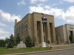 Webster County Courthouse in Dixon | |
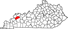 Location in the U.S. state of Kentucky | |
 Kentucky's location in the U.S. | |
| Founded | 1860 |
| Named for | Daniel Webster |
| Seat | Dixon |
| Largest city | Providence |
| Area | |
| • Total | 336 sq mi (870 km2) |
| • Land | 332 sq mi (860 km2) |
| • Water | 3.7 sq mi (10 km2), 1.1% |
| Population | |
| • (2010) | 13,621 |
| • Density | 41/sq mi (16/km²) |
| Congressional district | 1st |
| Time zone | Central: UTC-6/-5 |
| Website |
www |
Webster County is a county located in the U.S. state of Kentucky. As of the 2010 census, the population was 13,621.[1] Its county seat is Dixon. [2] It is the southernmost county in the Evansville, IN–KY Metropolitan Statistical Area. The county was formed in 1860 from parts of Henderson, Hopkins, and Union Counties[3] and named for American statesman Daniel Webster (1782-1852).[4] It was mainly pro-Confederate during the American Civil War and was the site several skirmishes and some guerrilla warfare. It is a prohibition or dry county.
Geography
According to the U.S. Census Bureau, the county has a total area of 336 square miles (870 km2), of which 332 square miles (860 km2) is land and 3.7 square miles (9.6 km2) (1.1%) is water.[5] Webster County is part of the Western Coal Fields region of Kentucky.
Adjacent counties
- Henderson County (north)
- McLean County (northeast)
- Hopkins County (southeast)
- Caldwell County (south)
- Crittenden County (southwest)
- Union County (northwest)
Demographics
| Historical population | |||
|---|---|---|---|
| Census | Pop. | %± | |
| 1870 | 10,937 | — | |
| 1880 | 14,246 | 30.3% | |
| 1890 | 17,196 | 20.7% | |
| 1900 | 20,097 | 16.9% | |
| 1910 | 20,974 | 4.4% | |
| 1920 | 20,762 | −1.0% | |
| 1930 | 20,534 | −1.1% | |
| 1940 | 19,198 | −6.5% | |
| 1950 | 15,555 | −19.0% | |
| 1960 | 14,244 | −8.4% | |
| 1970 | 13,282 | −6.8% | |
| 1980 | 14,832 | 11.7% | |
| 1990 | 13,955 | −5.9% | |
| 2000 | 14,120 | 1.2% | |
| 2010 | 13,621 | −3.5% | |
| Est. 2015 | 13,170 | [6] | −3.3% |
| U.S. Decennial Census[7] 1790-1960[8] 1900-1990[9] 1990-2000[10] 2010-2013[1] | |||
As of the census[11] of 2010, 5,272 households, and 3,716 families residing in the county. The population density was 42 per square mile (16/km2). There were 5,936 housing units at an average density of 19 per square mile (7.3/km2). The racial makeup of the county was 91.4% White, 4.1% Black or African American, 0.2% Native American, 0.3% Asian, 0.3% Pacific Islander, 2.3% from other races, and 1.4% from two or more races. 4.3% of the population were Hispanic or Latino of any race.
There were 5,272 households out of which 27.2% had children under the age of 18 living with them, 55% were married couples living together, 10.8% had a female householder with no husband present, and 29.5% were non-families. 25.4% of all households were made up of individuals and 11.6% had someone living alone who was 65 years of age or older. The average household size was 2.51 and the average family size was 2.98.
In the county the population was spread out with 25.9% under the age of 19, 5.8% from 20 to 24, 25% from 25 to 44, 28.2% from 45 to 64, and 15.1% who were 65 years of age or older. The median age was 40.1 years. 49.7% of the population is male and 50.3% female.
The median income for a household in the county was $39,635, and the median income for a family was $49,580. Males employed full-time had a median income of $41,662 versus $26,502 for females. The per capita income for the county was $18,879. About 11.9% of families and 16% of the population were below the poverty line, including 21.9% of those under age 18 and 11.6% of those age 65 or over.
Government officials
- County Judge/Executive - Stephen "Steve" Henry
- Magistrate - Tony Felker
- Magistrate - Pete O'Nan
- County Attorney - William Prow
- Coroner - Larry Vanover
- Sheriff - Frankie Springfield
- Jailer - Terry Elder
- County Surveyor - Garland Whitledge
- Property Valuation Administrator - Jeffrey Kelley
- County Clerk - Valerie Franklin
- Circuit Clerk - Amy Villines
National Association of Counties[12]
Communities
- Blackford
- Clay
- Dixon (county seat)
- Onton
- Poole
- Providence
- Sebree
- Slaughters
- Wheatcroft
Notable residents
- Robert A. Baker, psychologist, author, influential skeptic, and Past Fellow of the Committee for Skeptical Inquiry
- William O. Head, mayor of Louisville, Kentucky from 1909 to 1913
- Kristen Johnson, Miss Kentucky USA 2005, 2nd runner-up Miss USA 2005, Miss Kentucky Teen USA 2000, 2nd runner-up Miss Teen USA 2000, Miss Photogenic
- Chris Knight, musician/songwriter.
- Cale Young Rice, American poet and dramatist.
- Laban Lacy Rice, educator, author, and President of Cumberland University
- Garrett L. Withers, represented Kentucky in both the United States Senate and the House of Representatives
See also
References
- 1 2 "State & County QuickFacts". United States Census Bureau. Retrieved March 6, 2014.
- ↑ "Find a County". National Association of Counties. Retrieved 2011-06-07.
- ↑ http://www.kygenweb.net/counties/formation.html
- ↑ The Register of the Kentucky State Historical Society, Volume 1. Kentucky State Historical Society. 1903. p. 37.
- ↑ "2010 Census Gazetteer Files". United States Census Bureau. August 22, 2012. Retrieved August 20, 2014.
- ↑ "County Totals Dataset: Population, Population Change and Estimated Components of Population Change: April 1, 2010 to July 1, 2015". Retrieved July 2, 2016.
- ↑ "U.S. Decennial Census". United States Census Bureau. Retrieved August 20, 2014.
- ↑ "Historical Census Browser". University of Virginia Library. Retrieved August 20, 2014.
- ↑ "Population of Counties by Decennial Census: 1900 to 1990". United States Census Bureau. Retrieved August 20, 2014.
- ↑ "Census 2000 PHC-T-4. Ranking Tables for Counties: 1990 and 2000" (PDF). United States Census Bureau. Retrieved August 20, 2014.
- ↑ "American FactFinder". United States Census Bureau. Retrieved 2008-01-31.
- ↑ "Data & Demographics". National Association of Counties. Archived from the original on 2007-09-30. Retrieved 2007-06-11.
| Central City |  | |
|---|---|---|
| Municipalities with population over 5,000 in 2010 | ||
| Municipalities with population 1,000-5,000 in 2010 | ||
| Indiana Counties | ||
| Kentucky Counties | ||
Municipalities and communities of Webster County, Kentucky, United States | ||
|---|---|---|
| Cities | | |
| CDP | ||
| Other unincorporated communities | ||

Coordinates: 37°31′N 87°41′W / 37.52°N 87.68°W