Aiguilhe
| Aiguilhe | |
|---|---|
|
| |
 Aiguilhe | |
|
Location within Auvergne-Rhône-Alpes region  Aiguilhe | |
| Coordinates: 45°03′06″N 3°53′08″E / 45.0517°N 3.8856°ECoordinates: 45°03′06″N 3°53′08″E / 45.0517°N 3.8856°E | |
| Country | France |
| Region | Auvergne-Rhône-Alpes |
| Department | Haute-Loire |
| Arrondissement | Le Puy-en-Velay |
| Canton | Le Puy-en-Velay-Nord |
| Intercommunality | Le Puy-en-Velay |
| Government | |
| • Mayor (2008–2014) | Michel Roussel |
| Area1 | 1.1 km2 (0.4 sq mi) |
| Population (2009)2 | 1,593 |
| • Density | 1,400/km2 (3,800/sq mi) |
| Time zone | CET (UTC+1) |
| • Summer (DST) | CEST (UTC+2) |
| INSEE/Postal code | 43002 / 43000 |
| Elevation |
609–751 m (1,998–2,464 ft) (avg. 650 m or 2,130 ft) |
|
1 French Land Register data, which excludes lakes, ponds, glaciers > 1 km² (0.386 sq mi or 247 acres) and river estuaries. 2 Population without double counting: residents of multiple communes (e.g., students and military personnel) only counted once. | |
Aiguilhe is a commune in the Haute-Loire department in south-central France.
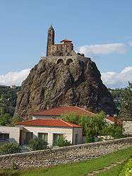
Aiguilhe is close to Le Puy-en-Velay, and famous for the Saint Michel chapel.
Population
| Historical population | ||
|---|---|---|
| Year | Pop. | ±% |
| 1962 | 1,016 | — |
| 1968 | 1,137 | +11.9% |
| 1975 | 1,304 | +14.7% |
| 1982 | 1,376 | +5.5% |
| 1990 | 1,452 | +5.5% |
| 1999 | 1,555 | +7.1% |
| 2006 | 1,595 | +2.6% |
| 2009 | 1,593 | −0.1% |
See also
References
| Wikimedia Commons has media related to Aiguilhe. |
This article is issued from Wikipedia - version of the 10/8/2016. The text is available under the Creative Commons Attribution/Share Alike but additional terms may apply for the media files.