Saint-Julien-du-Pinet
| Saint-Julien-du-Pinet | |
|---|---|
|
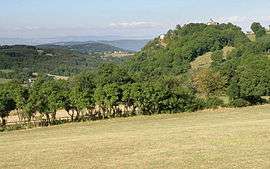
The Chapel of Glavenas, on the hill to the right, in Saint-Julien-du-Pinet | |
 Saint-Julien-du-Pinet | |
|
Location within Auvergne-Rhône-Alpes region  Saint-Julien-du-Pinet | |
| Coordinates: 45°09′10″N 4°02′24″E / 45.1528°N 4.04°ECoordinates: 45°09′10″N 4°02′24″E / 45.1528°N 4.04°E | |
| Country | France |
| Region | Auvergne-Rhône-Alpes |
| Department | Haute-Loire |
| Arrondissement | Yssingeaux |
| Canton | Yssingeaux |
| Intercommunality | Sucs |
| Government | |
| • Mayor | Étienne Charbonnier |
| Area1 | 17.2 km2 (6.6 sq mi) |
| Population (2006)2 | 422 |
| • Density | 25/km2 (64/sq mi) |
| Time zone | CET (UTC+1) |
| • Summer (DST) | CEST (UTC+2) |
| INSEE/Postal code | 43203 / 43200 |
| Elevation | 637–1,186 m (2,090–3,891 ft) |
|
1 French Land Register data, which excludes lakes, ponds, glaciers > 1 km² (0.386 sq mi or 247 acres) and river estuaries. 2 Population without double counting: residents of multiple communes (e.g., students and military personnel) only counted once. | |
Saint-Julien-du-Pinet is a commune in the Haute-Loire department in south-central France.
See also
References
| Wikimedia Commons has media related to Saint-Julien-du-Pinet. |
This article is issued from Wikipedia - version of the 2/11/2015. The text is available under the Creative Commons Attribution/Share Alike but additional terms may apply for the media files.