Monistrol-sur-Loire
| Monistrol-sur-Loire | ||
|---|---|---|
|
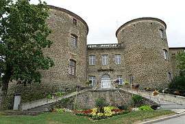
The Château des Évêques, in Monistrol-sur-Loire | ||
| ||
 Monistrol-sur-Loire | ||
|
Location within Auvergne-Rhône-Alpes region  Monistrol-sur-Loire | ||
| Coordinates: 45°17′36″N 4°10′22″E / 45.2933°N 4.1728°ECoordinates: 45°17′36″N 4°10′22″E / 45.2933°N 4.1728°E | ||
| Country | France | |
| Region | Auvergne-Rhône-Alpes | |
| Department | Haute-Loire | |
| Arrondissement | Yssingeaux | |
| Canton | Monistrol-sur-Loire | |
| Government | ||
| • Mayor (2008–2014) | Robert Valour | |
| Area1 | 48.25 km2 (18.63 sq mi) | |
| Population (2006)2 | 8,444 | |
| • Density | 180/km2 (450/sq mi) | |
| Time zone | CET (UTC+1) | |
| • Summer (DST) | CEST (UTC+2) | |
| INSEE/Postal code | 43137 / 43120 | |
| Elevation | 434–874 m (1,424–2,867 ft) | |
|
1 French Land Register data, which excludes lakes, ponds, glaciers > 1 km² (0.386 sq mi or 247 acres) and river estuaries. 2 Population without double counting: residents of multiple communes (e.g., students and military personnel) only counted once. | ||

Monistrol-sur-Loire is a commune in the Haute-Loire department in south-central France.
It is the birthplace of former Roman Catholic archbishop Armand-François-Marie de Charbonnel
Geography
The river Lignon du Velay flows into the Loire in the commune.
See also
| Wikimedia Commons has media related to Monistrol-sur-Loire. |
This article is issued from Wikipedia - version of the 2/11/2015. The text is available under the Creative Commons Attribution/Share Alike but additional terms may apply for the media files.