Blassac
| Blassac | |
|---|---|
|
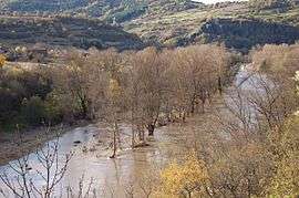
The church of Saint-Roch, perched on the volcanic promontory, during the Allier flood in November 2008 | |
 Blassac | |
|
Location within Auvergne-Rhône-Alpes region  Blassac | |
| Coordinates: 45°10′16″N 3°24′02″E / 45.1711°N 3.4006°ECoordinates: 45°10′16″N 3°24′02″E / 45.1711°N 3.4006°E | |
| Country | France |
| Region | Auvergne-Rhône-Alpes |
| Department | Haute-Loire |
| Arrondissement | Brioude |
| Canton | Lavoûte-Chilhac |
| Government | |
| • Mayor (2008–2014) | Francis Rome |
| Area1 | 12.56 km2 (4.85 sq mi) |
| Population (2009)2 | 150 |
| • Density | 12/km2 (31/sq mi) |
| Time zone | CET (UTC+1) |
| • Summer (DST) | CEST (UTC+2) |
| INSEE/Postal code | 43031 / 43380 |
| Elevation |
441–953 m (1,447–3,127 ft) (avg. 518 m or 1,699 ft) |
|
1 French Land Register data, which excludes lakes, ponds, glaciers > 1 km² (0.386 sq mi or 247 acres) and river estuaries. 2 Population without double counting: residents of multiple communes (e.g., students and military personnel) only counted once. | |
Blassac is a commune in the Haute-Loire department in south-central France.
Population
| Historical population | ||
|---|---|---|
| Year | Pop. | ±% |
| 1962 | 148 | — |
| 1968 | 174 | +17.6% |
| 1975 | 146 | −16.1% |
| 1982 | 143 | −2.1% |
| 1990 | 130 | −9.1% |
| 1999 | 121 | −6.9% |
| 2005 | 137 | +13.2% |
| 2009 | 150 | +9.5% |
See also
References
| Wikimedia Commons has media related to Blassac. |
This article is issued from Wikipedia - version of the 3/15/2016. The text is available under the Creative Commons Attribution/Share Alike but additional terms may apply for the media files.