Blesle
| Blesle | ||
|---|---|---|
|
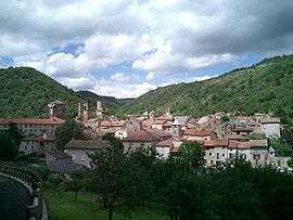
A general view of Blesle | ||
| ||
 Blesle | ||
|
Location within Auvergne-Rhône-Alpes region  Blesle | ||
| Coordinates: 45°19′11″N 3°10′17″E / 45.3197°N 3.1714°ECoordinates: 45°19′11″N 3°10′17″E / 45.3197°N 3.1714°E | ||
| Country | France | |
| Region | Auvergne-Rhône-Alpes | |
| Department | Haute-Loire | |
| Arrondissement | Brioude | |
| Canton | Blesle | |
| Government | ||
| • Mayor (2008–2014) | Pascal Gibelin | |
| Area1 | 29.8 km2 (11.5 sq mi) | |
| Population (2009)2 | 644 | |
| • Density | 22/km2 (56/sq mi) | |
| Time zone | CET (UTC+1) | |
| • Summer (DST) | CEST (UTC+2) | |
| INSEE/Postal code | 43033 / 43450 | |
| Elevation | 472–875 m (1,549–2,871 ft) | |
|
1 French Land Register data, which excludes lakes, ponds, glaciers > 1 km² (0.386 sq mi or 247 acres) and river estuaries. 2 Population without double counting: residents of multiple communes (e.g., students and military personnel) only counted once. | ||

Blesle is a commune in the Haute-Loire department in south-central France.
Population
| Historical population | ||
|---|---|---|
| Year | Pop. | ±% |
| 1962 | 837 | — |
| 1968 | 847 | +1.2% |
| 1975 | 832 | −1.8% |
| 1982 | 824 | −1.0% |
| 1990 | 703 | −14.7% |
| 1999 | 660 | −6.1% |
| 2006 | 657 | −0.5% |
| 2009 | 644 | −2.0% |
See also
References
| Wikimedia Commons has media related to Blesle. |
This article is issued from Wikipedia - version of the 2/11/2015. The text is available under the Creative Commons Attribution/Share Alike but additional terms may apply for the media files.