Al-Hawl
| al-Hawl الهول | |
|---|---|
| Town | |
 al-Hawl Location of al-Hawl in Syria | |
| Coordinates: 36°23′29″N 41°09′05″E / 36.3914°N 41.1514°ECoordinates: 36°23′29″N 41°09′05″E / 36.3914°N 41.1514°E | |
| Country |
|
| Governorate | al-Hasakah |
| District | al-Hasakah |
| Subdistrict | al-Hawl |
| Elevation | 452 m (1,483 ft) |
| Population (2004)[1] | 3,409 |
| Time zone | EET (UTC+2) |
| • Summer (DST) | EEST (UTC+3) |
| Geocode | C4519 |
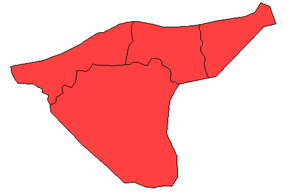
al-Hawl (Arabic: الهول, translit. al-Ḩawl, lit. '"swampland"'), also spelled al-Hol, al-Hool and al-Houl, is a town in eastern al-Hasakah Governorate, northeastern Syria. It is administrative center of the al-Hawl Nahiya consisting of 22 municipalities.
At the 2004 census, the town had a population of 3,409.[1]
During the Syrian Civil War, al-Hawl was seized and held under occupation by Islamic State forces. For both its strategic significance and its almost uniformly Arab population, it had become one of the major strongholds of the IS in northeastern Syria. On 13 November 2015, Al-Hawl was liberated by the Syrian Democratic Forces (SDF), in what was considered the SDF's first strategic success, since its establishment by People's Protection Units (YPG) and allied forces.[2]
Geography
The town is located some 40 kilometres (25 mi) east of al-Hasakah, on the southern bank of the dried-out wadi ‘Aţā Allāh. While the wadi has dried out, the spring ‘Ayn al-Hawl, located south of the town, still carries water. Nearby villages include Sheikh Ma'ad with the Sheikh Ma‘ad shrine to the north, just across the wadi.
Infrastructure
North of the town is a significant road junction connecting the provincial capital with the Iraqi border. While the northeastern branch proceeds towards Tall Hamis and the Rabia border crossing, the southeastern branch towards the Sinjar mountains passes through the town southeastwards, reaching the Makhfar Umm Jaris border crossing after some 20 kilometres (12 mi).
The town is surrounded by military bases formerly used by the Syrian Army.
al-Hawl Refugee Camp
In early 1991, during the Gulf war, the UNHCR (United Nations High Commissioner for Refugees) established a refugee camp on the southern outskirts of al-Hawl, which was operated in cooperation with the Syrian government[3] Along with another camp in al-Hasakah, provided shelter to at least 15.000 refugees from Iraq.[4] Following the 2003 Iraq War, the camp was later reopened as one of three camps at the Iraqi–Syrian border, when the US-occupied Iraq forcibly evicted thousands of Palestinians, including those who fled Kuwait at the 1991 Gulf War.[5]
Syrian Civil War
In the course of the Eastern al-Hasakah offensive of Syrian Kurdish YPG, the occupying Islamic State militants were expelled from large swaths of eastern Hasakah, including Tell Hamis and Tell Brak. The southeastern Hasakah countryside around al-Hawl however remained one of the last ISIL strongholds in the province.
When in October 2015, Kurdish YPG and their multiethnic partners, including the Sunni Arab Shammar tribe's al-Sanadid Forces, joined forces to form the Syrian Democratic Forces (SDF), al-Sanadid leader Bandar al-Humaydi made it an "immediate priority to liberate al-Hawl and Ash Shaddadi from the Islamic State.”[6]
In late October 2015, following the successful Battle of Hasakah, the SDF launched their al-Hawl offensive slowly advancing southwards from Tell Hamis. On 11 November they seized Khatuniyah and moved on around the lake further southwards to surround al-Hawl from both northeast and south on 12 November.[7] On 13 November, al-Hawl was liberated, in what was considered the SDF's first strategic success.[8] In the following days, the SDF advanced further westwards to close the remaining ISIL-held pocket around the villages of Abu Hajirat Khuatana and Khuwaytilah.[9]
References
- 1 2 "2004 Census Data for Nahiya al-Hawl" (in Arabic). Syrian Central Bureau of Statistics. Retrieved 15 October 2015. Also available in English: UN OCHA. "2004 Census Data". Humanitarian Data Exchange. Retrieved 4 December 2015.
- ↑ Master. "The Syrian Democratic Forces seize the town of al- Hol in the eastern countryside of al- Hasakah". Syrian Observatory For Human Rights. Archived from the original on 17 November 2015. Retrieved 14 November 2015.
- ↑ Bureau for Refugee Programs, US Department of State (ed.). "World refugee report 1992". p. 158.
- ↑ Third World Institute, ed. (2005). The World Guide: A View from the South 2005/06. Oxfam. p. 533. ISBN 978-1-904456-11-7.
- ↑ Mohsen Moh'd Saleh (ed.). The Palestinian Strategic Report 2007. Beirut: Al-Zaytouna Center. p. 357. ISBN 978-9953-500-676.
- ↑ Roy Gutman (27 October 2015). "New allies in northern Syria don't seem to share U.S. goals". McClatchy DC. Retrieved 7 November 2015.
- ↑ "SDF/YPG Offensive In East Hasakah". Retrieved 14 November 2015.
- ↑ Master. "The Syrian Democratic Forces seize the town of al- Hol in the eastern countryside of al- Hasakah". Syrian Observatory For Human Rights. Archived from the original on 17 November 2015. Retrieved 14 November 2015.
- ↑ Hasakah front: 1 December 2015


