Altwiller
| Altwiller Àltwiller | ||
|---|---|---|
|
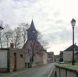
The Protestant Church | ||
| ||
 Altwiller | ||
|
Location within Grand Est region  Altwiller | ||
| Coordinates: 48°55′51″N 6°58′51″E / 48.9308°N 6.9808°ECoordinates: 48°55′51″N 6°58′51″E / 48.9308°N 6.9808°E | ||
| Country | France | |
| Region | Grand Est | |
| Department | Bas-Rhin | |
| Arrondissement | Saverne | |
| Canton | Ingwiller | |
| Government | ||
| • Mayor (2014–2020) | Aimé Schreiner | |
| Area1 | 16.22 km2 (6.26 sq mi) | |
| Population (2009)2 | 422 | |
| • Density | 26/km2 (67/sq mi) | |
| Time zone | CET (UTC+1) | |
| • Summer (DST) | CEST (UTC+2) | |
| INSEE/Postal code | 67009 / 67260 | |
| Elevation | 215–266 m (705–873 ft) | |
|
1 French Land Register data, which excludes lakes, ponds, glaciers > 1 km² (0.386 sq mi or 247 acres) and river estuaries. 2 Population without double counting: residents of multiple communes (e.g., students and military personnel) only counted once. | ||
Altwiller (German: Altweiler) is a French commune in the Bas-Rhin department in the Grand Est region of northeastern France.
The inhabitants of the commune are known as Altwillerois or Altwilleroises[1]
Geography
Altwiller is located some 20 km south of Sarreguemines on the German border and some 50 km north-east of Nancy. The commune is accessed by the D23 road running east from Vibersviller to the village then continuing east to Harskirchen. The D153 road also runs through the southern portion of the commune as it runs from the D39 road in the south-west north-east to Harskirchen. The western and northern borders of the commune are also the borders between the Bas-Rhin and Moselle departments. As well as Altwiller village there is also the hamlet of Chateau Bonnefontaine in the south of the commune.[2]
The Canal des Houllietes de la Satre passes along the southern border of the commune. The Rose stream passes near the village flowing west from Moselle to the Albe river partly forming the northern border of the commune. The northern part of the commune is farmland while the southern part is mainly forested.[2]
Neighbouring communes and villages[2]
 |
Honskirch | Hinsingen | Bissert | |
| Albestroff | |
Harskirchen | ||
| ||||
| | ||||
| Vibersviller | Mittersheim | Diedendorf |
History
Fragments of vases and other Gallo-Roman pieces have been found at Bonnefontaine. The site is located on the salt route. In addition to the two annexes of Neuweyershof and the Bonnefontaine domain the village had in its vicinity a hamlet called Honkesen-Huntzen which has now disappeared.
Altwiller was deserted in the 15th century and rebuilt a little later in 1559 mainly by Huguenots from Lorraine. It was partially destroyed again in 1635 by the Croatians then became the property of Sarrewerden then of Nassau-Saarbrücken with the capital of the Bailiwick of Harskirchen. The village returned to France in 1793.
Heraldry
 |
Blazon: Azure, a lion party per fess Or and Argent..[3] |
Administration
List of Successive Mayors of Altwiller[4]
| From | To | Name | Party | Position |
|---|---|---|---|---|
| 1989 | 2001 | Arthur Scwartz | Brigadier-General, Legion of Honour, Commander of National Order of Merit | |
| 2001 | 2008 | Gilbert Schmidt | ||
| 2008 | 2014 | Alain Lieb | ||
| 2014 | 2020 | Aimé Schreiner |
(Not all data is known)
Demography
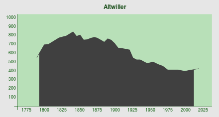
In 2009, the commune had 422 inhabitants. The evolution of the number of inhabitants is known through the population censuses conducted in the town since 1793. From the 21st century, a census of municipalities with fewer than 10,000 inhabitants is held every five years, unlike larger towns that have a sample survey every year.[Note 1]
| 1793 | 1800 | 1806 | 1821 | 1831 | 1836 | 1841 | 1846 | 1851 |
|---|---|---|---|---|---|---|---|---|
| 603 | 698 | 702 | 777 | 796 | 821 | 844 | 795 | 809 |
| 1856 | 1861 | 1866 | 1872 | 1876 | 1881 | 1886 | 1891 | 1896 |
|---|---|---|---|---|---|---|---|---|
| 752 | 756 | 773 | 782 | 775 | 753 | 728 | 767 | 751 |
| 1901 | 1906 | 1911 | 1921 | 1926 | 1931 | 1936 | 1946 | 1954 |
|---|---|---|---|---|---|---|---|---|
| 712 | 661 | 657 | 641 | 549 | 529 | 509 | 487 | 505 |
| 1962 | 1968 | 1975 | 1982 | 1990 | 1999 | 2009 | - | - |
|---|---|---|---|---|---|---|---|---|
| 474 | 456 | 416 | 414 | 415 | 399 | 422 | - | - |
Sources : Ldh/EHESS/Cassini until 1962, INSEE database from 1968 (population without double counting and municipal population from 2006)
Culture and heritage
Civil heritage
The commune has many buildings and structures that are registered as historical monuments:
- A House at Bonnefontaine (1908)
 [5]
[5] - A Farmhouse at Bonnefontaine (18th century)[6]
- A Farmhouse at Neuweyerhof (1) (1761)[7]
- A Farmhouse at Neuweyerhof (2) (1761)[8]
- A Farmhouse at 63 Rue des Lilas (1850)[9]
- A Farmhouse at 103 Rue Principale (1900)[10]
- A Farmhouse at 107 Rue Principale (1776)[11]
- A Farmhouse at 112 Rue Principale (1848)[12]
- A Farmhouse at 113 Rue Principale (18th century)[13]
- A Farmhouse at 114 Rue Principale (1813)[14]
- A Farmhouse at 5 Rue Principale (1776)[15]
- A Flour Mill at 51 Rue Principale (1724).[16] From the end of the 17th to the 20th century the mill was run by a single family of millers.
- A House and Shop at 88 Rue Principale (1934)[17]
- A Farmhouse at 89 Rue Principale (1838)[18]
- A School at 93 Rue Principale (1843)[19]
- A Farmhouse at 20 Rue de la Rose (1826)[20]
- A Farmhouse at 22 Rue de la Rose (18th century)[21]
- A Farmhouse at 26 Rue de la Rose (1862)[22]
- A Farmhouse at 31 Rue de la Rose (1898)[23]
- A Farmhouse at 36 Rue de la Rose (1875)[24]
- A Farmhouse at 41 Rue de la Rose (1909)[25]
- A Carpenter's House at 43 Rue de la Rose (1775)[26]
- The Domain of Bonnefontaine at Bonnefontaine (19th century)[27]
- The Chateau of Bonnefontaine (1818).[28] The mineral water spring discovered in 1603 was appetizing, diuretic and purgative. This gave the idea in 1816 to a banker from Basel to build a thermal spa with castle, park and dance hall. The castle was built between 1818 and 1822 but the operation ended in failure due to lack of customers. He sold the estate in 1836. The latest occupants of the castle are the Schlumberger family - owners since 1878.
- The Chateau of Bonnefontaine Park (1818)[29]
- The Canal des Houillères Lock 16 (19th century)[30]
- A School at Neuweyerhof (19th century)[31]
- Houses and Farms[32]
Religious heritage
The commune has several religious buildings and structures that are registered as historical monuments:
- The Protestant Church (1723).[33] There are several items in the church that are registered as historical objects:
- The Protestant Presbytery (1730)[38]
- The Lutheran Presbytery (16th century)[39]
- The Cemetery at RD 23. (19th century)[40] The movable items in the cemetery
 are registered as historical objects.[41]
See also
External links
- Altwiller on the old National Geographic Institute website (French)
- Altwiller on Lion1906
- Altwiller on Google Maps
- Altwiller on Géoportail, National Geographic Institute (IGN) website (French)
- Aiweiller on the 1750 Cassini Map
- Altwiller on the INSEE website (French)
- INSEE (French)
Notes and references
Notes
- ↑ At the beginning of the 21st century, the methods of identification have been modified by law No. 2002-276 of 27 February 2002 , the so-called "law of local democracy" and in particular Title V "census operations" which allow, after a transitional period running from 2004 to 2008, the annual publication of the legal population of the different French administrative districts. For municipalities with a population greater than 10,000 inhabitants, a sample survey is conducted annually, the entire territory of these municipalities is taken into account at the end of the period of five years. The first "legal population" after 1999 under this new law came into force on 1 January 2009 and was based on the census of 2006.
References
- ↑ Inhabitants of Bas-Rhin (French)
- 1 2 3 Google Maps
- ↑ Blazons of the communes of Bas-Rhin, Jean-Paul de Gassowski, consulted on 24 May 2009 (French)
- ↑ List of Mayors of France (French)
- ↑ Ministry of Culture, Mérimée IA67005727 House at Bonnefontaine (French)
- ↑ Ministry of Culture, Mérimée IA67005728 Farmhouse at Bonnefontaine (French)
- ↑ Ministry of Culture, Mérimée IA67005725 Farmhouse at Neuweyerhof (1) (French)
- ↑ Ministry of Culture, Mérimée IA67005726 Farmhouse at Neuweyerhof (2) (French)
- ↑ Ministry of Culture, Mérimée IA67005722 Farmhouse at 63 Rue des Lilas (French)
- ↑ Ministry of Culture, Mérimée IA67005709 Farmhouse at 103 Rue Principale (French)
- ↑ Ministry of Culture, Mérimée IA67005713 Farmhouse at 107 Rue Principale (French)
- ↑ Ministry of Culture, Mérimée IA67005712 Farmhouse at 112 Rue Principale (French)
- ↑ Ministry of Culture, Mérimée IA67005711 Farmhouse at 113 Rue Principale (French)
- ↑ Ministry of Culture, Mérimée IA67005714 Farmhouse at 114 Rue Principale (French)
- ↑ Ministry of Culture, Mérimée IA67005708 Farmhouse at 5 Rue Principale (French)
- ↑ Ministry of Culture, Mérimée IA67005723 Flour Mill at 51 Rue Principale (French)
- ↑ Ministry of Culture, Mérimée IA67005707 House and Shop at 88 Rue Principale (French)
- ↑ Ministry of Culture, Mérimée IA67005710 Farmhouse at 89 Rue Principale (French)
- ↑ Ministry of Culture, Mérimée IA67005706 School at 93 Rue Principale (French)
- ↑ Ministry of Culture, Mérimée IA67005716 Farmhouse at 20 Rue de la Rose (French)
- ↑ Ministry of Culture, Mérimée IA67005717 Farmhouse at 22 Rue de la Rose (French)
- ↑ Ministry of Culture, Mérimée IA67005718 Farmhouse at 26 Rue de la Rose (French)
- ↑ Ministry of Culture, Mérimée IA67005719 Farmhouse at 31 Rue de la Rose (French)
- ↑ Ministry of Culture, Mérimée IA67005715 Farmhouse at 36 Rue de la Rose (French)
- ↑ Ministry of Culture, Mérimée IA67005720 Farmhouse at 41 Rue de la Rose (French)
- ↑ Ministry of Culture, Mérimée IA67005721 Carpenter's House at 43 Rue de la Rose (French)
- ↑ Ministry of Culture, Mérimée PA00085292 Domain of Bonnefontaine (French)
- ↑ Ministry of Culture, Mérimée IA67005729 Chateau of Bonnefontaine (French)
- ↑ Ministry of Culture, Mérimée IA67011023 Chateau of Bonnefontaine Park (French)
- ↑ Ministry of Culture, Mérimée IA67005730 Canal des Houillères Lock 16 (French)
- ↑ Ministry of Culture, Mérimée IA67005724 School at Neuweyerhof (French)
- ↑ Ministry of Culture, Mérimée IA67005702 Houses and Farms (French)
- ↑ Ministry of Culture, Mérimée IA67005703 Protestant Church (French)
- ↑ Ministry of Culture, Palissy IM67009064 Organ (French)
- ↑ Ministry of Culture, Palissy IM67009063 Furniture in the Church (French)
- ↑ Ministry of Culture, Palissy IM67009062 Communion Ewer (French)
- ↑ Ministry of Culture, Palissy IM67009061 Baptismal Ewer (French)
- ↑ Ministry of Culture, Mérimée IA67005705 Protestant Presbytery (French)
- ↑ Ministry of Culture, Mérimée IA67005704 Lutheran Presbytery (French)
- ↑ Ministry of Culture, Mérimée IA67005731 Cemetery at RD 23 (French)
- ↑ Ministry of Culture, Palissy IM67009060 Movable Items in the Cemetery (French)
| Wikimedia Commons has media related to Altwiller. |