Barr, Bas-Rhin
| Barr | ||
|---|---|---|
|
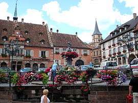
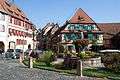
Town square | ||
| ||
 Barr | ||
|
Location within Grand Est region  Barr | ||
| Coordinates: 48°24′32″N 7°27′02″E / 48.4089°N 7.4506°ECoordinates: 48°24′32″N 7°27′02″E / 48.4089°N 7.4506°E | ||
| Country | France | |
| Region | Grand Est | |
| Department | Bas-Rhin | |
| Arrondissement | Sélestat-Erstein | |
| Canton | Barr | |
| Intercommunality | Piémont de Barr | |
| Government | ||
| • Mayor (2008–2014) | Gilbert Scholly | |
| Area1 | 20.61 km2 (7.96 sq mi) | |
| Population (2010)2 | 6,830 | |
| • Density | 330/km2 (860/sq mi) | |
| Time zone | CET (UTC+1) | |
| • Summer (DST) | CEST (UTC+2) | |
| INSEE/Postal code | 67021 / 67140 | |
| Elevation | 176–971 m (577–3,186 ft) | |
|
1 French Land Register data, which excludes lakes, ponds, glaciers > 1 km² (0.386 sq mi or 247 acres) and river estuaries. 2 Population without double counting: residents of multiple communes (e.g., students and military personnel) only counted once. | ||
Barr (in Alsatian Borr) is a French commune in the Bas-Rhin department in the Alsace region of north-eastern France.[1]
The inhabitants of the commune are known as Barrois or Barroises.[2]
The commune has been awarded three flowers by the National Council of Towns and Villages in Bloom in the Competition of cities and villages in Bloom.[3]
Geography
_Rue_typique.JPG)
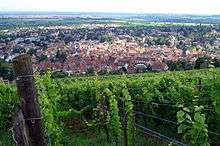
Barr lies in the foothills of the Vosges Mountains at the foot of Mont Sainte-Odile some 25 km south-west of Strasbourg and 5 km north of Epfig. The A35 autoroute passes through the eastern tip of the commune from north to south and Exit ![]() 13 lies in the tip of the commune. The D62 runs west through the commune from the exit to Andlau. Access to Barr town is by the D362 from Mittelbergheim in the south, by the D35 from Heiligenstein in the north, and by the D42 which branches from the D1422 north of Gertwiller. The D1422 from Gertwiller in the north runs from north to south through the east of the commune and continues to Saint-Pierre. The D854 goes from the town west through the length of the commune then north to join the D426 in the west. The D426 continues through the western part of the commune to Le Hohwald. The D109 comes from Saint-Nabor in the north to join the D854 in the west of the commune. The D130 branches off the D426 in the west of the commune and goes west to join the D214 at Rothlach. There is also Barr railway station in the town with the railway going north to Gertwiller station and south to Eichhoffen station.[4][5]
13 lies in the tip of the commune. The D62 runs west through the commune from the exit to Andlau. Access to Barr town is by the D362 from Mittelbergheim in the south, by the D35 from Heiligenstein in the north, and by the D42 which branches from the D1422 north of Gertwiller. The D1422 from Gertwiller in the north runs from north to south through the east of the commune and continues to Saint-Pierre. The D854 goes from the town west through the length of the commune then north to join the D426 in the west. The D426 continues through the western part of the commune to Le Hohwald. The D109 comes from Saint-Nabor in the north to join the D854 in the west of the commune. The D130 branches off the D426 in the west of the commune and goes west to join the D214 at Rothlach. There is also Barr railway station in the town with the railway going north to Gertwiller station and south to Eichhoffen station.[4][5]
Barr is the wine capital of Alsace with the oldest Alsace wine fair (over 100 years) and an historical "Harvest Festival" which is traditionally held the first weekend of October.
La Kirneck river rises in the west of the commune and flows eastwards through the town and continues east to join the Andlau.[4][5]
Mapping
A list of online mapping systems can be displayed by clicking on the coordinates (latitude and longitude) in the top right hand corner of this article.
Neighbouring communes and villages
 |
Saint-Nabor | Heiligenstein | | |
| Natzwiller | |
Zellwiller | ||
| ||||
| | ||||
| Le Hohwald | Mittelbergheim | Saint-Pierre |
Transport and communication routes
- Barr has a TER Alsace railway station located eight minutes walk from the city centre. There is a train every half-hour.
- The cycle route of the Alsatian vineyards (EuroVelo 5) passes through the centre of the city.
- Barr town is a step in the Vosges part of the hiking trail GR 5 and E2 European path.
- From 1889 to 1906 the Forest Railway Welschbruch was a narrow gauge forest railway along the river Kirneck.
Environment
Part of the "forest of Landsberg" is located in the commune. This forest has been owned by a forestry group run by six managers since 1800. The forest covers 158 hectares (nearly 25 ha unproductive) spread over 3 communes (Heiligenstein, Barr, and Obernai). It is the subject of a "close to nature forestry" management according to the principles recommended by Prosilva with no clear-felling. It was certified by the Forest Stewardship Council (FSC) in December 2000 and by the Programme for the Endorsement of Forest Certification (PEFC) in December 2002.[6]
History
Barr appears as Barr on the 1750 Cassini Map[7] and the same on the 1790 version.[8]
Although the first written records mentioning the village of Barr as Barru dates from the year 788, historians believe that the site was occupied long before as evidenced by many prehistoric remains of the Iron Age and Bronze Age discovered in the area.
Barr was originally an imperial property, but in 1522 the Habsburgs leased it to Nicolas Ziegler, and converted into Allod or freehold three years later. His son later sold it to the city of Strasbourg. This led to Barr being involved in the Bishop's War of Strasbourg (1592–1604) against the Catholics of Lorraine, which resulted in Barr's castle and many of its houses being razed to the ground in 1592.[9]
During the Thirty Years War it suffered from the Holy Roman Empire, the Swedes, and the French but less than the surrounding villages. During the conflict with Louis XIV in Strasbourg, the town was occupied by the French: the murder of an officer by a resident brought about the burning of the town in retaliation.
Rebuilding was rapid and thereafter Barr had no further disasters although it had to endure the passage of troops that had to be fed.
In the 18th century there was a legal process that lasted nearly a century opposing the ceding of the localities of the Lordship of Barr to the city of Strasbourg, their suzerain, who claimed all the forests of its vassal. In 1763 a first decision attributed the lands to Strasbourg; there was an appeal and it was not until 1836, under the July Monarchy, that the verdict was definitively confirmed.
Heraldry
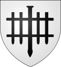 |
Blazon: Argent, a portcullis of Sable. |
The portcullis in the arms symbolizes the ancestral role of this city as the last barrier on the way to the Mont Sainte-Odile, formerly a sacred place occupied by the Druids.
Administration
| From | To | Name | Party | Position |
|---|---|---|---|---|
| 1815 | Jacques Dietz | |||
| 1962 | 1971 | Louis Klipfel[11] | Farmer | |
| 1971 | 1989 | Marcel Krieg | Doctor | |
| 1989 | 1995 | Michel Schwanger | ||
| 1995 | 2020 | Gilbert Scholly[12] | UMP | VP of Regional Council of Alsace since 1998 |
(Not all data is known)
Twinning
Barr has twinning associations with:[13]
Demography
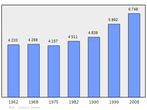
In 2010 the commune had 6830 inhabitants. The evolution of the number of inhabitants is known from the population censuses conducted in the commune since 1793. From the 21st century, a census of communes with fewer than 10,000 inhabitants is held every five years, unlike larger communes that have a sample survey every year.[Note 1]
| 1793 | 1800 | 1806 | 1821 | 1831 | 1836 | 1841 | 1846 | 1851 |
|---|---|---|---|---|---|---|---|---|
| 3,771 | 3,996 | 4,143 | 4,091 | 4,324 | 4,521 | 4,095 | 4,185 | 4,345 |
| 1856 | 1861 | 1866 | 1872 | 1876 | 1881 | 1886 | 1891 | 1896 |
|---|---|---|---|---|---|---|---|---|
| 4,737 | 4,877 | 5,082 | 5,655 | 5,945 | 5,857 | 5,646 | 5,678 | 5,576 |
| 1901 | 1906 | 1911 | 1921 | 1926 | 1931 | 1936 | 1946 | 1954 |
|---|---|---|---|---|---|---|---|---|
| 5,243 | 5,022 | 4,934 | 4,176 | 4,185 | 4,278 | 4,389 | 4,430 | 4,322 |
| 1962 | 1968 | 1975 | 1982 | 1990 | 1999 | 2006 | 2010 | - |
|---|---|---|---|---|---|---|---|---|
| 4,207 | 4,268 | 4,157 | 4,511 | 4,839 | 5,892 | 6,417 | 6,830 | - |
Sources : Ldh/EHESS/Cassini until 1962, INSEE database from 1968 (population without double counting and municipal population from 2006)
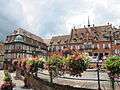
Culture and heritage
Barr has a very large number of buildings and sites that are registered as historical monuments. For a complete list including links to descriptions (in French) click here.
Highlights of some of the sites are:
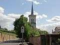
- The Protestant Church of Saint Martin)
 [14]
[14] - The Protestant and Catholic cemeteries
- Barracks, Saint Martin church - school and organ. The based was built by Stiehr Mockers and the instrument designed by Kriess.
- The old synagogue had to be destroyed in 1982 following the collapse of a corner pillar, but the windows of the synagogue were reused for the benefit of the Meinau oratory and some stones including the Tablets of Stone are displayed in the park of the Elisa Foundation in Strasbourg.[15]
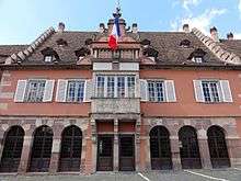
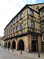
- The Town Hall
- A Coaching Inn
- The Museum of the Folie Marco
The commune has an enormous number of items that are registered as historical objects. For a complete list including links to descriptions (in French) click here.
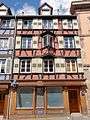
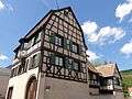
Picture Gallery
-

Catholic Cemetery
-
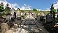
Protestant Cemetery
-
3 Rue de la Stey
-
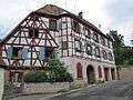
House in the Town Square
-

Ruined Chateau
-
.jpg)
Folie Marco Vineyards
-
.jpg)
Musée de la Folie Marco
-
.JPG)
The Main Street
-
26 Rue du Docteur-Sultzer
-
.JPG)
Old shoe factory
-
Barr
-
.JPG)
Rue du Docteur-Sulzer
-
.JPG)
Rue de la Kirneck
-
A row of houses
-
Town Hall
-
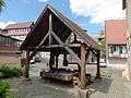
Old grape press
-
17 Rue College
-
Location of the old synagogue
-
.JPG)
Old water pump
-

The Protestant Church
-
Catholic Church
Culture
- The Municipal band Union of Barr has existed since 1863.
- The film by Tony Gatlif, Je suis né d'une cigogne (1999), with Romain Duris and Rona Hartner shot some scenes with the landscape of Barr[16]
Notable people linked to the commune
- Émile Bieckert (Don Emilio), who introduced the manufacture of beer to Argentina.
- Richard Hartmann, native of Barr, locomotive manufacturer who founded a large factory in Chemnitz
- Édouard Schuré, esoteric writer
- Jean Hermann, doctor and naturalist whose natiral history gave birth to the Musée zoologique de la ville de Strasbourg.
- Jean-Frédéric Hermann (1743-1820), brother of Jean, MP for Bas-Rhin and Mayor of Strasbourg.
- Charles Dietz-Monnin (1826-1896), politician, born in Barr.
- Martin von Feuerstein, artist - painter, born on 6 January 1856 in Barr and died 13 February 1931 at Munich.
- Henri Rieffel, surgeon and professor of anatomy at SAint Louis Hospital in Paris, born in 1862 in Barr, died at Villerville (Calvados) in 1939.
- Edmond Rinckenbach, artist - painter, born on 1 March 1862 in Barr and died 13 August 1902 at Metz.
- Paul Schmitthenner, German architect and University professor.
- Charles Alexis Vandenberg (1858-1942), Major-General commanding the 10eth Army Corps, was in Barr in 1918.
- Joseph Bloch, Grand Rabbi (1875-1970).[17]
- Isaac Eisik Roller, Grand Rabbi (1832-1900).[18]
- Pisla Helmstetter (1926-2013), author of memories of life of the Alsatian Roma community.
- Jean Joho, French expatriate chef in the United States[19]
See also
Bibliography
- "Alternative and simultaneum in the Bailiwick of Barr: a new balance between Lutherans and Catholics, 1681-1789", in Yearbook of the Society of History and Archaeology of Dambach-la-Ville, Barr, Obernai, 2013, No. 47, p. 115-130 (French)
- Meryem Grifty, Barr, for a history of past times or The history of urban development of the barroise city, M. Grifty, Strasbourg, 1998, 100 p. (French)
- Friedrich Hecker, Die Stadt Barr von der französischen Revolution bis auf unsere Tage, Strassburger Druckerei, 1911, 354 p. (German)
- Anémone Koffel, "Viticulture and wine producers in Barr 1815-1939", in Historic Buildings in Alsace, 1998 No. 1, p. 153-160 (French)
- Jean-Marie Le Minor, "Surgeons, barbers, and swimmers in Barr from the 16th to the 18th century", in Yearbook of the Society of History and Archaeology of Dambach-la-Ville, Barr, Obernai, 2004, No. 38, p. 109-136 (French)
- Claude Muller, From lived history: a barroise chronicle of Jacques Frey (1820-1898)", in Yearbook of the Society of History and Archaeology of Dambach-la-Ville, Barr, Obernai, 2011 No. 45, p. 8-12 (French)
- Renée Schneider, "Schools in Barr in the 20th century", in Yearbook of the Society of History and Archaeology of Dambach-la-Ville, Barr, Obernai, 2007, No. 41, p. 81-122 (French)
- Renée Schneider, "Industry in the 19th century: the family of Moses Barr", in Yearbook of the Society of History and Archaeology of Dambach-la-Ville, Barr, Obernai, 2010, No. 44, p. 27-58 (French)
- Renée Schneider, "From Alsace to America: the family Bartholmé Barr", in Yearbook of the Society of History and Archaeology of Dambach-la-Ville, Barr, Obernai, 2010, No. 44, p. 113-132 (French)
- Régine Philippe Schultz and Schultz, Once upon a time ... es war einmal ... Barr: a page of Alsatian history between 1870 and 1918, Ed Alsace, Colmar, 1993, 96 p.
- Emmanuel Solère Stintzy, "Barr: the authentic, not kitsch!", in In Alsace, 2005, No. 39, p. 54-68 (French)
Notes and references
Notes
- ↑ At the beginning of the 21st century, the methods of identification have been modified by Law No. 2002-276 of 27 February 2002, the so-called "law of local democracy" and in particular Title V "census operations" allows, after a transitional period running from 2004 to 2008, the annual publication of the legal population of the different French administrative districts. For communes with a population greater than 10,000 inhabitants, a sample survey is conducted annually and the entire territory of these communes is taken into account at the end of the period of five years. The first "legal population" after 1999 under this new law came into force on 1 January 2009 and was based on the census of 2006.
References
- ↑ Barr on Lion1906
- ↑ Inhabitants of Bas-Rhin (French)
- ↑ Competition for Towns and Villages in Bloom website Archived December 10, 2014, at the Wayback Machine. (French)
- 1 2 3 Barr on Google Maps
- 1 2 Barr on the Géoportail from National Geographic Institute (IGN) website (French)
- ↑ Presentation of the Forest of Landsberg, Prosilva, consulted 1 July 2012 (French)
- ↑ Barr on the 1750 Cassini Map
- ↑ Barr on the 1790 Cassini Map
- ↑ "BARR of the 16th century at the Revolution". Krucker family. Retrieved 2009-08-27.
- ↑ List of Mayors of France (French)
- ↑ The Louis-Klipfel Stadium: biography of a mayor (French)
- ↑ List of Mayors at 10 April 2014 on the Bas-Rhin prefectrue website (French)
- ↑ National Commission for Decentralised cooperation (French)
- ↑ Barr, Lutheran Parish (French)
- ↑ The reemployment of the windows of the synagogue
- ↑ The crazy anarchist revolt according to Gatlif, Le Monde, 24 November 1999, consulted on 24 February 2015. The Town Hall, the Kirchberg mountains, and the intersection of Rue Brune and Rue de l'École are recognisable places on-screen. Critique in Le Monde on the film by Tony Gatlif, Je suis né d'une cigogne (French)
- ↑ Grand Rabbi Joseph Bloch, Extract from the Tribune juive. He was author of a weekly calendar for jewish families which continues today. He was in Barr when there was a synagogue.
- ↑ The Franco-German War and the two sieges of Paris (1870-71), E. Roller (Amsterdam, 1878). (Hebrew)
- ↑ Jean Joho, a gastronomic chef businessman (French)
| Wikimedia Commons has media related to Barr, Bas-Rhin. |
| Wikisource has the text of the 1911 Encyclopædia Britannica article Barr. |