Geudertheim
| Geudertheim Gaiderte | ||
|---|---|---|
 | ||
| ||
 Geudertheim | ||
|
Location within Grand Est region  Geudertheim | ||
| Coordinates: 48°43′26″N 7°45′19″E / 48.7239°N 7.7553°ECoordinates: 48°43′26″N 7°45′19″E / 48.7239°N 7.7553°E | ||
| Country | France | |
| Region | Grand Est | |
| Department | Bas-Rhin | |
| Arrondissement | Haguenau-Wissembourg | |
| Canton | Brumath | |
| Government | ||
| • Mayor (2008–2014) | Pierre Gross | |
| Area1 | 11.27 km2 (4.35 sq mi) | |
| Population (2006)2 | 2,297 | |
| • Density | 200/km2 (530/sq mi) | |
| Time zone | CET (UTC+1) | |
| • Summer (DST) | CEST (UTC+2) | |
| INSEE/Postal code | 67156 / 67170 | |
| Elevation | 133–188 m (436–617 ft) | |
|
1 French Land Register data, which excludes lakes, ponds, glaciers > 1 km² (0.386 sq mi or 247 acres) and river estuaries. 2 Population without double counting: residents of multiple communes (e.g., students and military personnel) only counted once. | ||

Geudertheim is a commune in the Bas-Rhin department in Grand Est in north-eastern France.
Geography
Geudertheim is a village in the Basse Zorn district, in the heart of the Alsace Asparagus Country, positioned half way between Haguenau and Strasbourg. The Rhine and the German frontier are 15 kilometres (9 mi) to the east. Neighbouring villages are Hœrdt to the south, Bietlenheim to the east, Brumath to the west and Weitbruch to the north.
Notable people
- General Georges Picquart, who played a key role in the Dreyfus Affair, spent his early childhood in Geudertheim. On July 13, 2006, almost a century after the exoneration of Dreyfus, the Place de la Mairie was renamed Place General Picquart in his honour.
- Balthazar Alexis Henri Schauenburg, (also spelled Schauenbourg), (born in Hellimer on 31 July 1748) died in Geudertheim on 1 September 1831) was a French general who served in the wars of the French Revolution and the Empire.
Landmarks
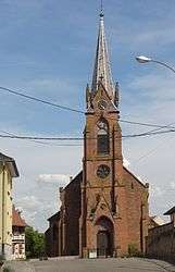
- The Protestant church dates from 1842: the church tower is from the twelfth century, however.
- The Roman Catholic Church dates from 1900. Attached to it is the fifteenth-century funerary chapel of the Schauenbourg family along with a fifteenth-century tabernacle considered one of the most beautiful in Alsace.
- Castle Schauenbourg.
- A mill on the Zorn River.
See also
References
| Wikimedia Commons has media related to Geudertheim. |
This article is issued from Wikipedia - version of the 11/13/2016. The text is available under the Creative Commons Attribution/Share Alike but additional terms may apply for the media files.