Huttendorf
| Huttendorf Hìttedorf | ||
|---|---|---|
 | ||
| ||
 Huttendorf | ||
|
Location within Grand Est region  Huttendorf | ||
| Coordinates: 48°48′06″N 7°38′27″E / 48.8017°N 7.6408°ECoordinates: 48°48′06″N 7°38′27″E / 48.8017°N 7.6408°E | ||
| Country | France | |
| Region | Grand Est | |
| Department | Bas-Rhin | |
| Arrondissement | Haguenau-Wissembourg | |
| Canton | Haguenau | |
| Government | ||
| • Mayor (2001–2008) | Bernard Ritter | |
| Area1 | 4.4 km2 (1.7 sq mi) | |
| Population (2006)2 | 414 | |
| • Density | 94/km2 (240/sq mi) | |
| Time zone | CET (UTC+1) | |
| • Summer (DST) | CEST (UTC+2) | |
| INSEE/Postal code | 67215 / 67270 | |
| Elevation | 190–268 m (623–879 ft) | |
|
1 French Land Register data, which excludes lakes, ponds, glaciers > 1 km² (0.386 sq mi or 247 acres) and river estuaries. 2 Population without double counting: residents of multiple communes (e.g., students and military personnel) only counted once. | ||
.svg.png)
Huttendorf (German: Hüttendorf) is a commune in the Bas-Rhin department in Grand Est in north-eastern France.
Geography
Agriculture, including livestock rearing, plays an important part in the village economy.
History
The first surviving record of the village appears under the name of Hittendorphe and dates from 797. At that time the settlement was part of the lands of the Abbey of Wissembourg.
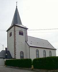
The church of Saint Vincent dates from 1746, although the tower is older. The organ, dating from 1853, was built by Pierre Rivenach.
See also
References
| Wikimedia Commons has media related to Huttendorf. |
This article is issued from Wikipedia - version of the 11/13/2016. The text is available under the Creative Commons Attribution/Share Alike but additional terms may apply for the media files.