Amwell Township, Washington County, Pennsylvania
| Amwell Township, Washington County, Pennsylvania | |
|---|---|
| Township | |
|
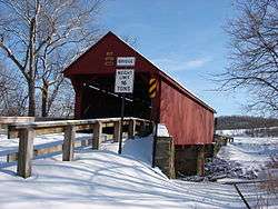
The Bailey Covered Bridge, a historic site in the township | |
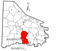 Map of Washington County, Pennsylvania highlighting Amwell Township | |
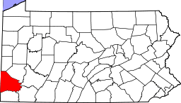 Map of Washington County, Pennsylvania | |
| Country | United States |
| State | Pennsylvania |
| County | Washington |
| Established | July 1, 1781 |
| Government | |
| • Type | Council |
| Area | |
| • Total | 44.8 sq mi (34 km2) |
| Population (2010) | |
| • Total | 3,960 |
| • Density | 88.3/sq mi (34/km2) |
| Time zone | Eastern (EST) (UTC-5) |
| • Summer (DST) | EDT (UTC-4) |
| Area code(s) | 724 |
Amwell Township is a township in Washington County, Pennsylvania, United States. The population was 3,960 at the 2000 census.
Geography
According to the United States Census Bureau, the township has a total area of 44.8 square miles (116 km2), all of it land.
History
Amwell Township was one of the original 13 townships in Washington County. The 13 townships were formed July 1, 1781. Abner Howell was the first person elected to the office of justice of the peace.
The Martin's Mill Covered Bridge, Bailey Covered Bridge, Dager-Wonsettler Farmstead, Hughes Covered Bridge, and Moses Little Tavern are listed on the National Register of Historic Places.[1]
Demographics
As of the census[2] of 2000, there were 3,960 people, 1,492 households, and 1,145 families residing in the township. The population density was 88.3 people per square mile (34.1/km²). There were 1,566 housing units at an average density of 34.9/sq mi (13.5/km²). The racial makeup of the township was 98.56% White, 0.61% African American, 0.13% Native American, 0.08% Asian, and 0.63% from two or more races. Hispanic or Latino of any race were 0.18% of the population.
There were 1,492 households out of which 32.6% had children under the age of 18 living with them, 66.2% were married couples living together, 7.2% had a female householder with no husband present, and 23.2% were non-families. 19.6% of all households were made up of individuals and 7.3% had someone living alone who was 65 years of age or older. The average household size was 2.64 and the average family size was 3.04.
In the township the population was spread out with 23.9% under the age of 18, 6.6% from 18 to 24, 29.1% from 25 to 44, 28.3% from 45 to 64, and 12.1% who were 65 years of age or older. The median age was 40 years. For every 100 females there were 96.5 males. For every 100 females age 18 and over, there were 95.7 males.
The median income for a household in the township was $44,922, and the median income for a family was $48,623. Males had a median income of $34,618 versus $21,006 for females. The per capita income for the township was $18,285. About 5.5% of families and 6.9% of the population were below the poverty line, including 7.4% of those under age 18 and 9.0% of those age 65 or over.
References
- ↑ National Park Service (2010-07-09). "National Register Information System". National Register of Historic Places. National Park Service.
- ↑ "American FactFinder". United States Census Bureau. Archived from the original on 2013-09-11. Retrieved 2008-01-31.
| Counties |  Map of the Pittsburgh Tri-State with green counties in the metropolitan area and yellow counties in the combined area. | |
|---|---|---|
| Major cities | ||
| Cities and towns 15k-50k (in 2010) | ||
| Airports | ||
| Topics | ||
| ||
Coordinates: 40°05′12″N 80°12′28″W / 40.08667°N 80.20778°W