Charleroi, Pennsylvania
| Charleroi | |
|---|---|
| Borough | |
|
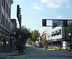
McKean Avenue | |
| Etymology: Charleroi, Belgium Charles the King | |
| Nickname(s): Magic City | |
| Motto: Business Friendly | |
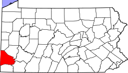
 Location of Charleroi in Washington County | |
 Charleroi Location of Charleroi in Pennsylvania | |
| Coordinates: 40°8′17″N 79°54′5″W / 40.13806°N 79.90139°WCoordinates: 40°8′17″N 79°54′5″W / 40.13806°N 79.90139°W | |
| Country | United States |
| State | Pennsylvania |
| County | Washington |
| Established | 1890 |
| Government | |
| • Paul Pervonick | Council President (D) |
| Area | |
| • Total | 0.9 sq mi (2 km2) |
| • Land | 0.8 sq mi (2 km2) |
| • Water | 0.1 sq mi (0.3 km2) |
| Population (2000) | |
| • Total | 4,871 |
| • Density | 5,400/sq mi (2,100/km2) |
| Time zone | EST (UTC-5) |
| • Summer (DST) | EDT (UTC-4) |
| Zip code | 15022 |
| Area code(s) | 724 |
National Register of Historic Places
Charleroi (/ˈʃɔːlərɔɪ/ SHAW-lə-roy) is a borough in Washington County, Pennsylvania, along the Monongahela River, 21 miles south of Pittsburgh.[1] Charleroi was settled in 1890 and incorporated in 1891.[2] The 2010 census recorded a population of 4,120.
There has been a large-scale cessation of industrial activities in the region. The decrease in the population is associated with the decline of regional heavy and medium industries, especially the steel-making industry, all once fed by the cheap transportation on the Monongahela River which extends from upstream of Charleroi well into northern West Virginia and north & downstream past McKeesport to the mouth of the Monongahela at Pittsburgh. Colloquially, the stretch from Charleroi north to McKeesport (historically because of press coverage of High School sports leagues), is known as the "Mon Valley"; or by some speakers (politicians, reporters and weathermen), the school-league-term has long been extended to mean from the river mouth to northern West Virginia.
History
Charleroi got its name (French for "Charles [the] King", referring to King Charles II of Spain) from Charleroi, Belgium. There lived many Belgian immigrants in the Monongahela area at the end of the 19th century, some of whom were glass makers. The neighbouring city of Pittsburgh has had the Belgian Charleroi as a sister city since 1976.[3]
The Pittsburgh Plate Glass Company, today PPG Industries, had one of its major factories located at the current chamber plaza, at one point employing up to a thousand employees, making it one of the largest glass factories in the world at the time. For years it was the home to one of Corning Glass Companies leading employers. Today it is home to World Kitchen, which makes pyrex.
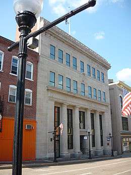
Charleroi was home to one of the first movie theatres in the nation, the electric theatre which opened in October 1905. The Charleroi Historic District, First National Bank of Charleroi and United States Post Office are listed on the National Register of Historic Places.[4][5]
Geography
Charleroi is located at 40°8′17″N 79°54′5″W / 40.13806°N 79.90139°W (40.138088, -79.901333).[6]
According to the United States Census Bureau, the borough has a total area of 0.9 square miles (2.3 km2), of which, 0.8 square miles (2.1 km2) of it is land and 0.1 square miles (0.26 km2) of it is water. The total area is 10.47% water.
Demographics
| Historical population | |||
|---|---|---|---|
| Census | Pop. | %± | |
| 1900 | 5,930 | — | |
| 1910 | 9,615 | 62.1% | |
| 1920 | 11,516 | 19.8% | |
| 1930 | 11,260 | −2.2% | |
| 1940 | 10,784 | −4.2% | |
| 1950 | 9,872 | −8.5% | |
| 1960 | 8,148 | −17.5% | |
| 1970 | 6,723 | −17.5% | |
| 1980 | 5,717 | −15.0% | |
| 1990 | 5,014 | −12.3% | |
| 2000 | 4,871 | −2.9% | |
| 2010 | 4,120 | −15.4% | |
| Est. 2015 | 4,015 | [7] | −2.5% |
| Sources:[8][9][10] | |||
As of the census[9] of 2000, there were 4,871 people, 2,258 households, and 1,208 families residing in the borough. The population density was 6,308.6 people per square mile (2,442.5/km²). There were 2,656 housing units at an average density of 3,439.9 per square mile (1,331.8/km²). The racial makeup of the borough was 95.3% White, 3.2% African American, 0.1% Native American, 0.3% Asian, 0.2% from other races, and 0.8% from two or more races. Hispanic or Latino of any race were 0.7% of the population.
There were 2,258 households out of which 22.3% had children under the age of 18 living with them, 35.5% were married couples living together, 13.37% had a female householder with no husband present, and 46.5% were non-families. 41.8% of all households were made up of individuals and 21.9% had someone living alone who was 65 years of age or older. The average household size was 2.11 and the average family size was 2.88.
In the borough the population was spread out with 20.5% under the age of 18, 7.1% from 18 to 24, 27.1% from 25 to 44, 20.2% from 45 to 64, and 25.0% who were 65 years of age or older. The median age was 41 years. For every 100 females there were 81.4 males. For every 100 females age 18 and over, there were 77.1 males.
The median income for a household in the borough was $23,593, and the median income for a family was $31,699. Males had a median income of $30,093 versus $23,873 for females. The per capita income for the borough was $13,752. About 16.1% of families and 21.3% of the population were below the poverty line, including 36.2% of those under age 18 and 13.7% of those age 65 or over.
In popular culture
- A large part of the plot of the alternate history novel The Two Georges, by Harry Turtledove and Richard Dreyfuss, takes place in Charleroi, Pennsylvania. In the alternate history of this book, North America remains part of the British Empire. Charleroi is described as a large coal-mining town filled with embittered coal miners of mainly Irish descent living under conditions of poverty, exploitation and pollution, who end up supporting radical underground political movements.
- Charleroi and the surrounding area are the setting for American Rust: A Novel by Philipp Meyer, a book that was originally published in 2009.
Notable people
- Shirley Jones (1934- ), singer, actress on Broadway, movies, and television
- Lisa Kirk (1925-1990), singer, actress
- Mitchell Paige (Serbian: Mihajlo Pejic) (1918-2003), WW2 Medal of Honor recipient
- Craig McCracken (1971- ), animator, director, producer
- Myron Pottios (1939- ), Professional Football player via All American Notre Dame 1959.
Bp. Keith L. Ackerman, bishop, Rector of St. Mary's Church Charleroi, 1976-1989
References
- ↑ City Distance Calculator
- ↑
 Chisholm, Hugh, ed. (1911). "Charleroi (Pennsylvania)". Encyclopædia Britannica. 5 (11th ed.). Cambridge University Press. p. 897.
 - ↑ Les villes jumelées avec Charleroi
- ↑ National Park Service (2010-07-09). "National Register Information System". National Register of Historic Places. National Park Service.
- ↑ For more about the designation as a historic district and about the Charleroi history: David Templeton, "Charleroi's story is history. Town built for glass factory could be large historic district", Pittsburgh Post-Gazette, February 8, 2004
- ↑ "US Gazetteer files: 2010, 2000, and 1990". United States Census Bureau. 2011-02-12. Retrieved 2011-04-23.
- ↑ "Annual Estimates of the Resident Population for Incorporated Places: April 1, 2010 to July 1, 2015". Retrieved July 2, 2016.
- ↑ "Census of Population and Housing". U.S. Census Bureau. Archived from the original on 11 May 2015. Retrieved 11 December 2013.
- 1 2 "American FactFinder". United States Census Bureau. Archived from the original on 2013-09-11. Retrieved 2008-01-31.
- ↑ "Incorporated Places and Minor Civil Divisions Datasets: Subcounty Resident Population Estimates: April 1, 2010 to July 1, 2012". Population Estimates. U.S. Census Bureau. Archived from the original on 17 June 2013. Retrieved 11 December 2013.
External links
| Wikimedia Commons has media related to Charleroi Historic District. |
| Counties |  Map of the Pittsburgh Tri-State with green counties in the metropolitan area and yellow counties in the combined area. | |
|---|---|---|
| Major cities | ||
| Cities and towns 15k-50k (in 2010) | ||
| Airports | ||
| Topics | ||
| ||