Condit Crossing, Pennsylvania
| Condit Crossing | |
|---|---|
| Unincorporated community | |
 Condit Crossing Location within the state of Pennsylvania | |
| Coordinates: 40°3′56″N 80°13′49″W / 40.06556°N 80.23028°WCoordinates: 40°3′56″N 80°13′49″W / 40.06556°N 80.23028°W | |
| Country | United States |
| State | Pennsylvania |
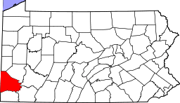
| County | Washington |
| Elevation | 997 ft (304 m) |
| Time zone | Eastern (EST) (UTC-5) |
| • Summer (DST) | EDT (UTC-4) |
Condit Crossing is an unincorporated community on Banetown Road in Washington County, Pennsylvania, United States.[1] Condit Crossing is located 28 miles southwest of Pittsburgh in the Eastern Time Zone and has an elevation of 997 feet.[2] Condit Crossing is not a census designated or incorporated place having an official federally recognized name. Condit Crossing appears on the Amity U.S. Geological Survey Map and observes daylight saving time.[3]
Major Intersection
South of Condit Crossing, Banetown Road intersects with Pettit Road to the northwest and Ross Road to the southwest. Banetown, Pennsylvania is north of Condit Crossing.[4]
Railroad Service
Condit Crossing was a stop on the Waynesburg and Washington Railroad. This rail line connected the county seats of Washington and Greene counties. The rail line has now fallen into disrepair.[5]
History
The place takes its name from one of the earliest settlers to the county, Jonas Condit, who came to the area in about 1794.[6]
References
| Counties |  Map of the Pittsburgh Tri-State with green counties in the metropolitan area and yellow counties in the combined area. | |
|---|---|---|
| Major cities | ||
| Cities and towns 15k-50k (in 2010) | ||
| Airports | ||
| Topics | ||
| ||