East Finley Township, Washington County, Pennsylvania
| East Finley Township | |
|---|---|
| Township | |
|
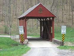
Sprowl's Covered Bridge (1875) National Register of Historic Places | |
 Location of East Finley Township in Washington County | |
 Location of Washington County in Pennsylvania | |
| Country | United States |
| State | Pennsylvania |
| County | Washington County |
| Area | |
| • Total | 35.1 sq mi (91 km2) |
| Population (2000) | |
| • Total | 1,489 |
| • Density | 42/sq mi (16/km2) |
| Time zone | EST (UTC-4) |
| • Summer (DST) | EDT (UTC-5) |
| Area code(s) | 724 |
East Finley Township is a township in Washington County, Pennsylvania, United States. The population was 1,489 at the 2000 census.
History
The Scott Brownlee Covered Bridge, Plant's Covered Bridge, Sprowl's Covered Bridge and Wyit Sprowls Covered Bridge are listed on the National Register of Historic Places.[1]
Geography
According to the United States Census Bureau, the township has a total area of 35.1 square miles (91 km2), all of it land.
Demographics
As of the census[2] of 2000, there were 1,489 people, 516 households, and 423 families residing in the township. The population density was 42.4 people per square mile (16.4/km²). There were 550 housing units at an average density of 15.7/sq mi (6.0/km²). The racial makeup of the township was 99.73% White, 0.13% African American, 0.07% Native American, and 0.07% from two or more races.
There were 516 households out of which 36.6% had children under the age of 18 living with them, 71.7% were married couples living together, 6.2% had a female householder with no husband present, and 18.0% were non-families. 15.7% of all households were made up of individuals and 7.4% had someone living alone who was 65 years of age or older. The average household size was 2.84 and the average family size was 3.17.
In the township the population was spread out with 27.0% under the age of 18, 6.9% from 18 to 24, 28.2% from 25 to 44, 26.1% from 45 to 64, and 11.9% who were 65 years of age or older. The median age was 38 years. For every 100 females there were 109.1 males. For every 100 females age 18 and over, there were 103.2 males.
The median income for a household in the township was $39,063, and the median income for a family was $43,516. Males had a median income of $31,250 versus $20,078 for females. The per capita income for the township was $14,675. About 9.9% of families and 12.1% of the population were below the poverty line, including 18.6% of those under age 18 and 4.4% of those age 65 or over.
References
- ↑ National Park Service (2010-07-09). "National Register Information System". National Register of Historic Places. National Park Service.
- ↑ "American FactFinder". United States Census Bureau. Retrieved 2008-01-31.
| Counties |  Map of the Pittsburgh Tri-State with green counties in the metropolitan area and yellow counties in the combined area. | |
|---|---|---|
| Major cities | ||
| Cities and towns 15k-50k (in 2010) | ||
| Airports | ||
| Topics | ||
| ||
Coordinates: 39°59′54″N 80°21′59″W / 39.99833°N 80.36639°W