Blainsburg, Pennsylvania
| Blainsburg, Pennsylvania | |
|---|---|
| Hamlet, Unincorporated bedroom community | |
| Blainsburg, West Brownsville, Pennsylvania | |
| Country | United States |
| State | Pennsylvania |
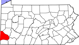
| County | Washington |
| GovernmentBlainsburg is a neighborhood of West Brownsville | |
| • Type | p/o West Brownsville |
| Elevation Elevation reported at point where GoogleEarth locates search to "Blainsburg, West Brownsville, PA[1] | 957 ft (292 m) |
| Time zone | Eastern (EST) (UTC-5) |
| • Summer (DST) | EDT (UTC-4) |
Blainsburg or Blainsburg, West Brownsville, PA is an unincorporated outlier community of West Brownsville, PA; by tradition a hamlet sized neighborhood with more actual housing acreage than W. Brownsville proper in Washington County, Pennsylvania, United States. Named after a U.S. Senator, the bedroom community is situated on the bluff above and slightly North-northwest of West Brownsville on the river bottom below.
Blainsburg is located alongside but above the climb PA Route 88 makes from the W. Brownsville river flats (Locally known as Blaine Hill Road) which bends right entering a shelf where it connects with the northwest streets of Blainsburg before taking a second ascent (now becoming California Road) towards California.[2] The parent and child communities are on the inside curve of a great meander in the Monongahela River in Southwestern Pennsylvania creating a degraded cut bank turned ramp and terrace on the opposite shore where Brownsville is situated.
Geography
The majority of elevations[3] in (very flat) West Brownsville average 770-780 ft, while only a short distance away the elevations in the larger street grid of Blainsburg run from 930-1040 feet. Measured at Pittsburgh Rd. Jct. with 5th Avenue, the elevation in Blainsburg is 940 feet (290 m), nearly 170 feet (52 m) above the junction of Main St. and Pittsburgh Rd. in West Brownsville. The GoogleEarth ruler tool reports the distance between the two points is 980 feet (300 m)—a gradient of 18.57%—a very steep slope by any measure.
Pennsylvania Route 88 climbs roughly parallel (starting from farther south in West Brownsville and rises at slower rate, so the higher side of Blainsburg is actually atop a bluff lining and overlooking the more moderated climb of the highway. In addition, Blainsburg over looks a rail yard and an important railroad bridge built by the Monongahela Railroad tying the railroad wye, sidings, and small yard in Brownsville along Albany Road with the much larger yard in West Brownsville.
References
- ↑ Elevation at point where GoogleEarth locates search to "Blainsburg, West Brownsville, PA"
- ↑ PA Route 88 is an old style two lane highway that connects the business districts of left bank communities in the Mon Valley.
- ↑ Elevations in this section are 'measured' satellite data or USGS reported by GoogleEarth software.
External Links
| Counties |  Map of the Pittsburgh Tri-State with green counties in the metropolitan area and yellow counties in the combined area. | |
|---|---|---|
| Major cities | ||
| Cities and towns 15k-50k (in 2010) | ||
| Airports | ||
| Topics | ||
| ||
Coordinates: 40°01′56″N 79°52′51″W / 40.03222°N 79.88083°W