Blaine Township, Washington County, Pennsylvania
| Blaine Township | |
|---|---|
| Township | |
|
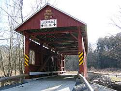
Sawhill Covered Bridge National Register of Historic Places | |
| Etymology: James G. Blaine | |
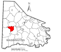 Location of Blaine Township in Washington County | |
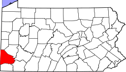 Location of Washington County in Pennsylvania | |
| Country | United States |
| State | Pennsylvania |
| County | Washington County |
| Area | |
| • Total | 11.9 sq mi (31 km2) |
| Population (2000) | |
| • Total | 597 |
| • Density | 50/sq mi (19/km2) |
| Time zone | EST (UTC-4) |
| • Summer (DST) | EDT (UTC-5) |
| Area code(s) | 724 |
Blaine Township is a township in Washington County, Pennsylvania, United States. The population was 597 at the 2000 census.
History
The Sawhill Covered Bridge and Taylorstown Historic District are listed on the National Register of Historic Places.[1]
Geography
According to the United States Census Bureau, the township has a total area of 11.9 square miles (31 km2), all of it land. It is named after former United States Secretary of State and Republican candidate for the 1884 presidential election, James G. Blaine a native of West Brownsville in Washington County. Taylorstown is an unincorporated community within the township.
Regional coal mining
Longwall mining, a form of coal mining, has devastated the region surrounding Blaine Township. Longwall mining creates giant underground pits which has caused land to sag and homes to collapse in Washington County. Springs, wells, and creeks have dried up as aquifers have drained into cracks in the ground caused by mining activity.[2][3] Fresh water sources in the region have been contaminated by mining tailings leaking toxins into drinking water sources such as aquifers and creeks.[4]
Blaine Township ordinances
Citizens of Blaine Township have passed restrictive ordinances in 2006, 2007, and 2008 which ban coal mining, require businesses to publicly disclose activities, and assert that corporations do not have constitutional rights as 'persons' to sue a municipality for passing laws that would hurt corporate interests.
The township's Corporate Rights Ordinance of 2006 states, "This illegitimate bestowal of civil and political rights upon corporations prevents the administration of laws within Blaine Township and usurps basic human and constitutional rights guaranteed to the people of Blaine Township."[5]
Town supervisors, including Board Spokesman Michael Vacca, say they want to establish a principle of local self-government that will inspire other communities.[6]
Demographics
As of the census[7] of 2000, there were 597 people, 217 households, and 172 families residing in the township. The population density was 50.4 people per square mile (19.5/km²). There were 223 housing units at an average density of 18.8/sq mi (7.3/km²). The racial makeup of the township was 98.32% White, 0.17% Asian, 0.17% from other races, and 1.34% from two or more races. Hispanic or Latino of any race were 0.34% of the population.
There were 217 households out of which 39.6% had children under the age of 18 living with them, 71.9% were married couples living together, 6.0% had a female householder with no husband present, and 20.3% were non-families. 19.4% of all households were made up of individuals and 8.3% had someone living alone who was 65 years of age or older. The average household size was 2.75 and the average family size was 3.16.
In the township the population was spread out with 28.1% under the age of 18, 5.5% from 18 to 24, 29.0% from 25 to 44, 28.3% from 45 to 64, and 9.0% who were 65 years of age or older. The median age was 39 years. For every 100 females there were 103.8 males. For every 100 females age 18 and over, there were 99.5 males.
The median income for a household in the township was $37,941, and the median income for a family was $39,926. Males had a median income of $32,115 versus $18,750 for females. The per capita income for the township was $15,167. About 5.1% of families and 6.2% of the population were below the poverty line, including 9.0% of those under age 18 and none of those age 65 or over.
References
- ↑ National Park Service (2010-07-09). "National Register Information System". National Register of Historic Places. National Park Service.
- ↑ Lombardi, Kristen; Sarah Laskow (January 12, 2009). "The Big Seep" (PDF). Center for Public Integrity. pp. 3–17. Retrieved 2009-08-11.
- ↑ Frederick, Mark (October 22, 2004). "Notes of Field Investigation at Trib 32596, Bailey Mine CMAP, 30841316, Richhill Township, Greene County" (PDF). Pennsylvania Department of Environmental Protection. Pennsylvania Public Records. pp. 1–2. Retrieved 2009-08-11.
- ↑ Scharding-Taras, Chelsea (10 April 2007). "Analytical Report for Mining and Reclamation Sample ID: 4622 014, Washington County" (PDF). Pennsylvania Department of Environmental Protection Bureau of Laboratories. Pennsylvania Public Record. pp. 1–4. Retrieved 2009-08-11.
- ↑ Second Class Township of Blaine Township, Washington County, Pennsylvania (2006). "Blaine Township Corporate Rights Ordinance: Eliminating Legal Powers and Privileges from Corporations Doing Business Within Blaine Township to Vindicate the Right to Democratic Self-Governance". Washington County Public Record. Archived from the original on April 11, 2009. Retrieved 2009-08-11.
- ↑ Hurdle, Jon (June 15, 2009). "Pennsylvania town fights big coal on mining rights". Thomson Reuters. p. 1. Retrieved 2009-08-02.
- ↑ "American FactFinder". United States Census Bureau. Archived from the original on 2013-09-11. Retrieved 2008-01-31.
| Counties |  Map of the Pittsburgh Tri-State with green counties in the metropolitan area and yellow counties in the combined area. | |
|---|---|---|
| Major cities | ||
| Cities and towns 15k-50k (in 2010) | ||
| Airports | ||
| Topics | ||
| ||
Coordinates: 40°10′53″N 80°23′14″W / 40.18139°N 80.38722°W