Annepont
| Annepont | |
|---|---|
|
Watermill | |
 Annepont | |
|
Location within Nouvelle-Aquitaine region  Annepont | |
| Coordinates: 45°50′38″N 0°36′49″W / 45.844°N 0.6136°WCoordinates: 45°50′38″N 0°36′49″W / 45.844°N 0.6136°W | |
| Country | France |
| Region | Nouvelle-Aquitaine |
| Department | Charente-Maritime |
| Arrondissement | Saint-Jean-d'Angély |
| Canton | Saint-Savinien |
| Intercommunality | Pays Savinois |
| Government | |
| • Mayor (2001–2020) | Francis Boizumault |
| Area1 | 8.81 km2 (3.40 sq mi) |
| Population (2009)2 | 324 |
| • Density | 37/km2 (95/sq mi) |
| Time zone | CET (UTC+1) |
| • Summer (DST) | CEST (UTC+2) |
| INSEE/Postal code | 17011 / 17350 |
| Elevation |
3–62 m (9.8–203.4 ft) (avg. 14 m or 46 ft) |
|
1 French Land Register data, which excludes lakes, ponds, glaciers > 1 km² (0.386 sq mi or 247 acres) and river estuaries. 2 Population without double counting: residents of multiple communes (e.g., students and military personnel) only counted once. | |
_moulin_%C3%A0_eau.JPG)
Annepont is a French commune in the Charente-Maritime department in the Nouvelle-Aquitaine region of southwestern France.
The inhabitants of the commune are known as Annepontois or Annepontoises[1]
Geography
Annepont is located some 15 km south-west of Saint-Jean-d'Angely and 13 km north of Saintes. The A10 autoroute (E5) passes through the west of the commune but has no exit in or near the commune. Access to the commune is by the D127 from Taillebourg to the south-west passing though the village and continuing north to Mazeray. The D230 road also goes east from the village to Juico. The D231 also passes through the south of the commune forming part of the southern border and continues to Écoyeux to the south-east. The commune has extensive forests in the east covering some 40% of the land area with the rest of the commune farmland.
The Ruisseau de la Blanchardiere rises in the east of the commune and flows west joining with numerous other streams.[2]
Neighbouring communes and villages[2]
 |
Saint-Savinien | Grandjean | La Frédière | |
| |
Juico | |||
| ||||
| | ||||
| Taillebourg | Saint-Vaize | Le Douhet |
Toponymy
Toponymists do not mention an old form for this place name so that the etymology of Annepont remains hypothetical. Albert Dauzat saw a compound of the elements Anna, a Germanic personal name, followed by the Gallo-Roman Ponte (from the Latin pons) meaning "bridge".[3]
Ernest Nègre agreed on the nature of the second element -pont but interpreted the first in a radically different way: it is possibly the local term asne meaning "humpbacked" - i.e. "humpbacked bridge".[4]
N.B.: There is a Germanic personal name Anna which is unrelated to the Hebrew personal name Hanna(h) (giving Anna then Anne). This anthroponym is an hypocoristic Germanic anthroponym beginning with the element Arn-. The final a rather indicates a Saxon origin. This hypothesis is supported by the existence of a number of place names in the region (notably in -ville) so the first element could be a Saxon anthroponym. In addition, archaeological excavations confirm the presence of Saxons in the region. This far south a compound structure is expected rather than the Romanesque *Pontanne but Annepont is more reminiscent of a toponymic type of northern France marked by Germanic influence and made from a Germanic anthroponym as for Radepont, Senarpont, Hubertpont, Carlepont, etc. The solution advocated by Ernest Negro, if possible phonetically, is even more hypothetical inasmuch as an ancient form of the type *Asnepont is required.
Administration
List of Successive Mayors[5]
| From | To | Name | Party | Position |
|---|---|---|---|---|
| 2001 | 2020 | Francis Boizumault |
(Not all data is known)
Demography
In 2009 the commune had 324 inhabitants. The evolution of the number of inhabitants is known from the population censuses conducted in the commune since 1793. From the 21st century, a census of communes with fewer than 10,000 inhabitants is held every five years, unlike larger towns that have a sample survey every year.[Note 1]
| 1793 | 1800 | 1806 | 1821 | 1831 | 1836 | 1841 | 1846 | 1851 |
|---|---|---|---|---|---|---|---|---|
| 370 | 392 | 380 | 328 | 423 | 432 | 421 | 415 | 377 |
| 1856 | 1861 | 1866 | 1872 | 1876 | 1881 | 1886 | 1891 | 1896 |
|---|---|---|---|---|---|---|---|---|
| 400 | 385 | 364 | 353 | 362 | 395 | 389 | 382 | 359 |
| 1901 | 1906 | 1911 | 1921 | 1926 | 1931 | 1936 | 1946 | 1954 |
|---|---|---|---|---|---|---|---|---|
| 338 | 332 | 330 | 315 | 334 | 326 | 288 | 328 | 262 |
| 1962 | 1968 | 1975 | 1982 | 1990 | 1999 | 2006 | 2009 | - |
|---|---|---|---|---|---|---|---|---|
| 216 | 184 | 177 | 220 | 208 | 267 | 264 | 324 | - |
Sources : Ldh/EHESS/Cassini until 1962, INSEE database from 1968 (population without double counting and municipal population from 2006)
_monument_aux_morts_devant_%C3%89glise_Saint-Andr%C3%A9_PA00104592.JPG)

Distribution of Age Groups
The population of the commune is relatively old. The proportion of persons above the age of 60 years (26.2%) is higher than the national rate (21.6%) while being less than the departmental rate (28.1%). Like the national and departmental allocations, the female population of the commune is higher than the male population. The rate (50.9%) is of the same order of magnitude as the national rate (51.6%).
Percentage Distribution of Age Groups in Annepont and Charente-Maritime Department in 2009
| Anneport | Anneport | Charente-M | Charente-M | |
|---|---|---|---|---|
| Age Range | Men | Women | Men | Women |
| 0 to 14 Years | 20.1 | 15.2 | 17.2 | 15.1 |
| 15 to 29 Years | 12.6 | 17.6 | 16.5 | 14.4 |
| 30 to 44 Years | 21.4 | 18.8 | 18.7 | 17.9 |
| 45 to 59 Years | 20.8 | 21.2 | 21.0 | 20.8 |
| 60 to 74 Years | 10.7 | 15.8 | 17.2 | 17.8 |
| 75 to 89 Years | 13.2 | 10.3 | 9.0 | 12.4 |
| 90 Years+ | 1.3 | 1.2 | 0.5 | 1.5 |
Sources:
- Evolution and Structure of the population of the Commune in 2009, INSEE.
- Evolution and Structure of the population of the Department in 2009, INSEE.
Culture and heritage
Civil heritage
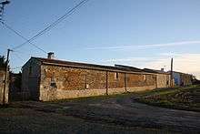
- The Logis of Maine-Moreau (17th century)
 , located in the Annepont countryside, is registered as an historical monument.[6]
Religious heritage
_%C3%89glise_Saint-Andr%C3%A9_PA00104592_chevet.JPG)
- The Church of Saint-André (12th century) is registered as an historical monument.[7] The Romanesque church is located on a promontory and distinguished by a gate without a tympanum surrounded by Corinthian capitals and its ornamented chevet beautifully executed. Old houses surrounding the building give a special character to the whole.
Transport
Railway Stations and Halts
- Taillebourg (Halt) 2.7 km
- Saint-Savinien (Halt) 6 km
- Saint-Hilaire-de-Villefranche, Brizambourg (Halt) 6.3 km
- Saintes 10.6 km
- Saint-Jean-d'Angely 13.6 km
Airport and aerodrome
- Rochefort-St-Agnant 28.9 km
- Cognac 31 km
- Royan-Medis Aerodrome 36.6 km
See also
External links
- Annepont on the National Geographic Institute website (French)
- Annepont on Lion1906
- Annepont on Google Maps
- Annepont on Géoportail, National Geographic Institute (IGN) website (French)
- Annepont on the 1750 Cassini Map
- Annepont on the INSEE website (French)
- INSEE (French)
Notes and references
Notes
- ↑ At the beginning of the 21st century, the methods of identification have been modified by law No. 2002-276 of 27 February 2002 , the so-called "law of local democracy" and in particular Title V "census operations" allows, after a transitional period running from 2004 to 2008, the annual publication of the legal population of the different French administrative districts. For communes with a population greater than 10,000 inhabitants, a sample survey is conducted annually, the entire territory of these communes is taken into account at the end of the period of five years. The first "legal population" after 1999 under this new law came into force on 1 January 2009 and was based on the census of 2006.
References
- ↑ Inhabitants of Charente-Maritime (French)
- 1 2 Google Maps
- ↑ DNLF 20b.
- ↑ Ernest Nègre, General Toponymy of France Read online (French)
- ↑ List of Mayors of France
- ↑ Ministry of Culture, Mérimée PA00104593 Logis of Maine-Moreau (French)
- ↑ Ministry of Culture, Mérimée PA00104592 Church of Saint-André (French)

| Wikimedia Commons has media related to Annepont. |