Les Nouillers
| Les Nouillers | |
|---|---|
|
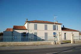
Town hall | |
 Les Nouillers | |
|
Location within Nouvelle-Aquitaine region  Les Nouillers | |
| Coordinates: 45°55′56″N 0°39′45″W / 45.9322°N 0.6625°WCoordinates: 45°55′56″N 0°39′45″W / 45.9322°N 0.6625°W | |
| Country | France |
| Region | Nouvelle-Aquitaine |
| Department | Charente-Maritime |
| Arrondissement | Saint-Jean-d'Angély |
| Canton | Saint-Savinien |
| Government | |
| • Mayor (2008–2014) | Stéphane Ardoin |
| Area1 | 24.15 km2 (9.32 sq mi) |
| Population (2008)2 | 626 |
| • Density | 26/km2 (67/sq mi) |
| Time zone | CET (UTC+1) |
| • Summer (DST) | CEST (UTC+2) |
| INSEE/Postal code | 17266 / 17380 |
| Elevation |
2–64 m (6.6–210.0 ft) (avg. 48 m or 157 ft) |
|
1 French Land Register data, which excludes lakes, ponds, glaciers > 1 km² (0.386 sq mi or 247 acres) and river estuaries. 2 Population without double counting: residents of multiple communes (e.g., students and military personnel) only counted once. | |
Les Nouillers is a commune in the Charente-Maritime department in the Nouvelle-Aquitaine region in southwestern France.
Geography
The river Boutonne forms all of the commune's northern border.
Population
| Historical population | ||
|---|---|---|
| Year | Pop. | ±% |
| 1962 | 544 | — |
| 1968 | 593 | +9.0% |
| 1975 | 534 | −9.9% |
| 1982 | 618 | +15.7% |
| 1990 | 607 | −1.8% |
| 1999 | 611 | +0.7% |
| 2008 | 626 | +2.5% |
Sights
- The Chateau of Nouillers built in the 16th century
See also
References
External links
| Wikimedia Commons has media related to Les Nouillers. |
This article is issued from Wikipedia - version of the 11/11/2016. The text is available under the Creative Commons Attribution/Share Alike but additional terms may apply for the media files.