Arthenac
| Arthenac | |
|---|---|
 | |
 Arthenac | |
|
Location within Nouvelle-Aquitaine region  Arthenac | |
| Coordinates: 45°30′57″N 0°18′48″W / 45.5158°N 0.3133°WCoordinates: 45°30′57″N 0°18′48″W / 45.5158°N 0.3133°W | |
| Country | France |
| Region | Nouvelle-Aquitaine |
| Department | Charente-Maritime |
| Arrondissement | Jonzac |
| Canton | Jonzac |
| Intercommunality | Haute-Saintonge |
| Government | |
| • Mayor (2001–2020) | Chantal Guimberteau |
| Area1 | 12.66 km2 (4.89 sq mi) |
| Population (2010)2 | 328 |
| • Density | 26/km2 (67/sq mi) |
| Time zone | CET (UTC+1) |
| • Summer (DST) | CEST (UTC+2) |
| INSEE/Postal code | 17020 / 17520 |
| Elevation |
43–111 m (141–364 ft) (avg. 72 m or 236 ft) |
|
1 French Land Register data, which excludes lakes, ponds, glaciers > 1 km² (0.386 sq mi or 247 acres) and river estuaries. 2 Population without double counting: residents of multiple communes (e.g., students and military personnel) only counted once. | |
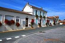
Arthenac is a French commune in the Charente-Maritime department in the Nouvelle-Aquitaine region of south-western France.
The inhabitants of the commune are known as Arthenacais or Arthenacaises[1]
The commune has been awarded three flowers by the National Council of Towns and Villages in Bloom in the Competition of cities and villages in Bloom.[2]
Geography
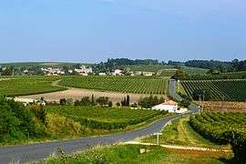
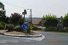
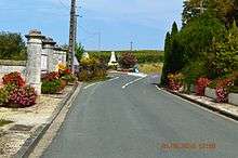
Arthenac is located in the south of Charente-Maritime in the former province of Saintonge some 24 km south-east of Pons, 16 km north-east of Jonzac, and immediately south-west of Archiac. Access to the commune is by the D699 road from Archiac in the north-west passing through the village and continuing south-west to Réaux. There is also the D251 road from Sainte-Lheurine in the north-west passing through south of the village to Saint-Eugène in the south-east. The D149 comes from the D700 in the north passing through the village then south to Allas-Champagne. The commune is mostly farmland with two large forests south of the village.[3]
Neighbouring communes and villages
 |
Sainte-Lheurine | Archiac | | |
| Neuillac | |
Saint-Eugène | ||
| ||||
| | ||||
| Moings | Allas-Champagne | Guimps |
History
Under the Ancien Régime Arthenac was independent but was merged with Archiac in 1789. The commune regained its independent status on 13 October 1831.
Administration
List of Successive Mayors[4]
| From | To | Name | Party | Position |
|---|---|---|---|---|
| 2001 | 2020 | Chantal Guimberteau | DVD |
(Not all data is known)
Demography
In 2010 the commune had 328 inhabitants. The evolution of the number of inhabitants is known from the population censuses conducted in the commune since 1831. From the 21st century, a census of communes with fewer than 10,000 inhabitants is held every five years, unlike larger towns that have a sample survey every year.[Note 1]
| 1793 | 1800 | 1806 | 1821 | 1831 | 1836 | 1841 | 1846 | 1851 |
|---|---|---|---|---|---|---|---|---|
| - | - | - | - | 779 | 742 | 759 | 731 | 726 |
| 1856 | 1861 | 1866 | 1872 | 1876 | 1881 | 1886 | 1891 | 1896 |
|---|---|---|---|---|---|---|---|---|
| 711 | 688 | 633 | 618 | 645 | 568 | 509 | 500 | 454 |
| 1901 | 1906 | 1911 | 1921 | 1926 | 1931 | 1936 | 1946 | 1954 |
|---|---|---|---|---|---|---|---|---|
| 503 | 537 | 515 | 462 | 459 | 465 | 446 | 410 | 418 |
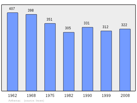
| 1962 | 1968 | 1975 | 1982 | 1990 | 1999 | 2006 | 2010 | - |
|---|---|---|---|---|---|---|---|---|
| 407 | 398 | 351 | 305 | 331 | 312 | - | 328 | - |
Sources : Ldh/EHESS/Cassini until 1962, INSEE database from 1968 (population without double counting and municipal population from 2006)
Distribution of Age Groups
The population of the town is relatively old. The ratio of persons above the age of 60 years (27.2%) is higher than the national average (21.6%) but less than the departmental average (28.1%). Unlike national and departmental allocations, the male population of the town is greater than the female population (50.2% against 48.4% nationally and 48.2% at the departmental level).
Percentage Distribution of Age Groups in Arthenac and Charente-Maritime Department in 2010
| Arthenac | Arthenac | Charente-M | Charente-M | |
|---|---|---|---|---|
| Age Range | Men | Women | Men | Women |
| 0 to 14 Years | 18.9 | 16.8 | 17.2 | 15.1 |
| 15 to 29 Years | 9.8 | 15.6 | 16.4 | 14.3 |
| 30 to 44 Years | 19.5 | 17.3 | 18.4 | 17.7 |
| 45 to 59 Years | 24.4 | 19.7 | 20.8 | 20.6 |
| 60 to 74 Years | 14.6 | 15.0 | 17.6 | 18.2 |
| 75 to 89 Years | 12.2 | 13.9 | 9.1 | 12.5 |
| 90 Years+ | 0.6 | 1.7 | 0.6 | 1.6 |
Sources:
- Evolution and Structure of the population of the Commune in 2010, INSEE.
- Evolution and Structure of the population of the Department in 2010, INSEE.
Sites and monuments

- The Church of Saint Martin (12th century)
 at Arthenac has had its central window restored. It is registered as a historical monument.[5]
See also
Notes
- ↑ At the beginning of the 21st century, the methods of identification have been modified by Law No. 2002-276 of 27 February 2002, the so-called "law of local democracy" and in particular Title V "census operations" allows, after a transitional period running from 2004 to 2008, the annual publication of the legal population of the different French administrative districts. For communes with a population greater than 10,000 inhabitants, a sample survey is conducted annually, the entire territory of these communes is taken into account at the end of the period of five years. The first "legal population" after 1999 under this new law came into force on 1 January 2009 and was based on the census of 2006.
References
- ↑ Inhabitants of Charente-Maritime (French)
- ↑ Arthenac in the Competition for Towns and Villages in Bloom Archived December 10, 2014, at the Wayback Machine. (French)
- ↑ Google Maps
- ↑ List of Mayors of France (French)
- ↑ Ministry of Culture, Mérimée PA00104601 Church of Saint Martin (French)

External links
- Arthenac on the National Geographic Institute website (French)
- Arthenac on Lion1906
- Arthenac on the 1750 Cassini Map
- Arthenac on the INSEE website (French)
- INSEE (French)
| Wikimedia Commons has media related to Arthenac. |