Anais, Charente-Maritime
| Anais | |
|---|---|
 Anais | |
|
Location within Nouvelle-Aquitaine region  Anais | |
| Coordinates: 46°11′16″N 0°54′26″W / 46.1878°N 0.9072°WCoordinates: 46°11′16″N 0°54′26″W / 46.1878°N 0.9072°W | |
| Country | France |
| Region | Nouvelle-Aquitaine |
| Department | Charente-Maritime |
| Arrondissement | La Rochelle |
| Canton | La Jarrie |
| Intercommunality | Plaine d'Aunis |
| Government | |
| • Mayor (2014–2020) | Bruno Gautronneau |
| Area1 | 9.44 km2 (3.64 sq mi) |
| Population (2009)2 | 313 |
| • Density | 33/km2 (86/sq mi) |
| Time zone | CET (UTC+1) |
| • Summer (DST) | CEST (UTC+2) |
| INSEE/Postal code | 17007 / 17540 |
| Elevation |
3–29 m (9.8–95.1 ft) (avg. 16 m or 52 ft) |
|
1 French Land Register data, which excludes lakes, ponds, glaciers > 1 km² (0.386 sq mi or 247 acres) and river estuaries. 2 Population without double counting: residents of multiple communes (e.g., students and military personnel) only counted once. | |
Anais is a French commune in the Charente-Maritime department in the Nouvelle-Aquitaine region of southwestern France.
The inhabitants of the commune are known as Anaisiens or Anaisiennes[1]
Geography
Anais is located some 15 km east of La Rochelle and 5 km south by south-east of Nuaille-d'Aunis. It can be accessed by the D107 road from Dompierre-sur-Mer in the west passing through the centre of the commune south of the village and continuing to Bouhet. The D113 road also comes from Virson in the south passing through the southern part of the commune and continuing north-east to Le Gué-d'Alleré. Access to the village in the north of the commune is only by small country roads running off the D107 and the D113. Apart from the small village of Anais there is also a larger village called Les Grandes-Rivieres located on the D113 road.
The Curé stream forms the eastern boundary of the commune and the Virson forms the northern part of the western boundary and they both meet at a place called le Gouffre (the Pit) which is the start of the Canal du Curé on the municipal boundary of the neighbouring commune of Angliers.[2]
The small village of Anais is built on a low limestone hill, at an altitude of about 13 metres, and it is surrounded by numerous marshes, being located in the southern part of the Marais Poitevin which belongs geographically and historically the plain of Aunis.
It is in this part of the Marais Poitevin that the course of the Curé enters the vast marshy bowl after leaving the last calcareous soils of Aunis in the neighbouring commune of Bouhet.
Neighbouring communes and villages[2]
 |
Angliers | Nuaille-d'Aunis | Saint-Sauveur-d'Aunis | |
| Vennes | |
Le Gué-d'Alleré | ||
| ||||
| | ||||
| Saint-Christophe | Virson | Bouhet |
Administration
List of Successive Mayors[3]
| From | To | Name | Party | Position |
|---|---|---|---|---|
| 2001 | 2014 | Gérard Grelier | SE | Retired |
| 2014 | 2020 | Bruno Gautronneau |
(Not all data is known)
Demography
According to the INSEE census of 2007 Anais had 284 inhabitants which was an increase of 35% compared to 1999. The town is 22,811th in size at the national level compared to 25,469th in 1999 and 353rd at the departmental level out of 472 communes.
In 2009 the commune had 313 inhabitants. The evolution of the number of inhabitants is known through the population censuses conducted in the commune since 1793. From the 21st century, a census of communes with fewer than 10,000 inhabitants is held every five years, unlike larger towns that have a sample survey every year.[Note 1]
| 1793 | 1800 | 1806 | 1821 | 1831 | 1836 | 1841 | 1846 | 1851 |
|---|---|---|---|---|---|---|---|---|
| 210 | 257 | 254 | 262 | 281 | 303 | 310 | 287 | 297 |
| 1856 | 1861 | 1866 | 1872 | 1876 | 1881 | 1886 | 1891 | 1896 |
|---|---|---|---|---|---|---|---|---|
| 321 | 311 | 331 | 340 | 327 | 303 | 275 | 297 | 327 |
| 1901 | 1906 | 1911 | 1921 | 1926 | 1931 | 1936 | 1946 | 1954 |
|---|---|---|---|---|---|---|---|---|
| 309 | 271 | 279 | 276 | 247 | 243 | 226 | 202 | 200 |
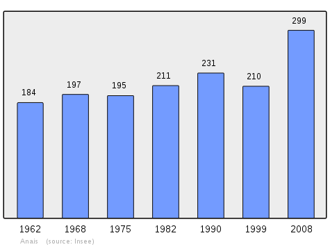
| 1962 | 1968 | 1975 | 1982 | 1990 | 1999 | 2006 | 2009 | - |
|---|---|---|---|---|---|---|---|---|
| 184 | 197 | 195 | 211 | 231 | 210 | 244 | 313 | - |
Sources : Ldh/EHESS/Cassini until 1962, INSEE database from 1968 (population without double counting and municipal population from 2006)
Distribution of Age Groups
The population of the commune is relatively young. The rate of persons above the age of 60 years (15.7%) is lower than the national rate (21.6%) and the departmental rate (28.1%). Unlike the national and departmental proportions, the male population of the town is greater than the female population (53% against 48.4% nationally and 48.2% at the departmental level).
The distribution of the population of the municipality by age groups was, in 2009 53% of men and 47% of women.
Percentage Distribution of Age Groups in Anais and Charente-Maritime Department in 2009
| Anais | Anais | Charente-M | Charente-M | |
|---|---|---|---|---|
| Age Range | Men | Women | Men | Women |
| 0 to 14 Years | 23.5 | 23.1 | 17.2 | 15.1 |
| 15 to 29 Years | 16.3 | 15.6 | 16.5 | 14.4 |
| 30 to 44 Years | 25.9 | 27.2 | 18.7 | 17.9 |
| 45 to 59 Years | 18.1 | 19.0 | 21.0 | 20.8 |
| 60 to 74 Years | 12.0 | 10.2 | 17.2 | 17.8 |
| 75 to 89 Years | 3.6 | 4.1 | 9.0 | 12.4 |
| 90 Years+ | 0.6 | 0.7 | 0.5 | 1.5 |
Sources:
- Evolution and Structure of the population of the Commune in 2009, INSEE.
- Evolution and Structure of the population of the Department in 2009, INSEE.
Sites and Monuments
- The Church of Saint Peter from the 10th century.
Transport
Nearest Railway Stations and Halts
- Surgères (TGV) 14 km
- Mer 17.8 km
- Aytré (halt) 18.1 km
- Mauzé-sur-le-Mignon (halt) 18.2 km
- Châtelaillon 18.5 km
Nearest Airport and aerodromes
- La Rochelle (Laleu) 22.1 km
- Rochefort-Saint-Agnant 33.8 km
- Niort-Souché 41.4 km
See also
External links
- Anais on the National Geographic Institute website (French)
- Anais on Lion1906
- Anais on Google Maps
- Anais on Géoportail, National Geographic Institute (IGN) website (French)
- Ancix on the 1750 Cassini Map
- Anais on the INSEE website (French)
- INSEE (French)
Notes and references
Notes
- ↑ At the beginning of the 21st century, the methods of identification have been modified by law No. 2002-276 of 27 February 2002 , the so-called "law of local democracy" and in particular Title V "census operations" which allow, after a transitional period running from 2004 to 2008, the annual publication of the legal population of the different French administrative districts. For communes with a population greater than 10,000 inhabitants, a sample survey is conducted annually, the entire territory of these communes is taken into account at the end of the period of five years. The first "legal population" after 1999 under this new law came into force on 1 January 2009 and was based on the census of 2006.
References
| Wikimedia Commons has media related to Anais (Charente-Maritime). |