Hot Springs Village, Arkansas
| Hot Springs Village, Arkansas | |
|---|---|
| CDP | |
 Location in Garland County and Arkansas | |
 Hot Springs Village, Arkansas Location in the United States | |
| Coordinates: 34°39′52″N 92°59′46″W / 34.66444°N 92.99611°WCoordinates: 34°39′52″N 92°59′46″W / 34.66444°N 92.99611°W | |
| Country | United States |
| State | Arkansas |
| Counties |
Garland County Saline County |
| Area | |
| • Total | 55.702 sq mi (144.27 km2) |
| • Land | 53.519 sq mi (138.61 km2) |
| • Water | 2.183 sq mi (5.65 km2) |
| Elevation | 784 ft (239 m) |
| Population (2010) | |
| • Total | 12,807 |
| • Density | 230/sq mi (89/km2) |
| Time zone | Central (CST) (UTC-6) |
| • Summer (DST) | CDT (UTC-5) |
| ZIP codes | 71909, 71910[1] |
| Area code(s) | 501 |
| FIPS code | 05-33482 |
| GNIS feature ID | 0072091 |
| Website |
www |
Hot Springs Village is a census-designated place (CDP) in Garland and Saline counties in the U.S. state of Arkansas. As it is situated in two counties, it is also part of two metropolitan statistical areas. The portion in Garland County is within the Hot Springs Metropolitan Statistical Area, while the portion extending into Saline County is part of the Little Rock–North Little Rock–Conway Metropolitan Statistical Area. The population was 12,807 at the 2010 census.[2] It is the largest gated community in the United States.
Geography
Hot Springs Village is located at 34°39′52″N 92°59′46″W / 34.66444°N 92.99611°W (34.664504, -92.996192).[3] According to the United States Census Bureau, the CDP has a total area of 55.7 square miles (144 km2), of which, 53.5 square miles (139 km2) of it is land and 2.2 square miles (5.7 km2) of it (3.92%) is water.
Governance
Hot Springs Village (HSV) is the largest gated community in the United States with more than 26,000 heavily-wooded acres. HSV is governed by the HSV Property Owners' Association (POA), a private, tax-exempt home owners association. A general manager and a seven-member volunteer Board of Directors, who are elected in staggered three-year terms, comprise the guiding force in Hot Springs Village. The day-to-day running of the POA is handled by an average of 475 employees assigned to one of six departments: Administration, Golf, Planning & Inspections, Public Safety, Public Works, and Recreation.
In addition to the Planning and Inspections Department, HSV's Architectural Control Committee's responsibility is to ensure that all building plans conform to architectural policy and building codes of the Village and to issue permits for new homes, landscaping, and remodeling. The Village also has a Common Property and Forest Committee which ensures that green belt areas, roadways, lakes, and other common areas are protected for general character, appearance and use by Hot Springs Village property owners.
Hot Springs Village has a Declaration and Covenants and Restrictions with which all property owners must comply. The POA also has an Information and Regulations booklet which has many of the recreation amenities rules. All HSV common property and the following amenities (and more) are owned by the property owners as a whole and maintained, regulated and operated by the POA:
- Eleven recreation lakes plus an isolated water-supply lake. The largest, Lake Balboa, is 944 acres.
- Three beaches, two full-service marinas, including boat rentals
- Two lake-side, covered pavilion complexes for group picnics for up to 300+ people
- Nine golf courses (some of which are top-rated in Arkansas)
- The only 5-star tennis association in Arkansas (includes 10 clay courts)
- Indoor and outdoor swimming complexes
- One of the largest bridge clubs in the United States (listed in the "Top 50" most active duplicate bridge clubs of the ACBL).
- Coronado Fitness Center, a large, extensively equipped fitness center
- More than 20 miles (32 km) of hiking trails
- Coronado Community Center, with more than 18,000 square feet (1,700 m2) of meeting rooms, including a 3,600-square-foot (330 m2) library with over 15,000 catalogued items (plus paperbacks),
- Ponce de Leon Community Center, with more than 11,000 square feet (1,000 m2), plus the 650-seat Woodlands Auditorium for the performing arts. The center's Casa de Carta is home to one of the largest Duplicate Bridge clubs in the U.S., with more than 800 members. Ponce de Leon's Ouachita Activities Building has large and small meeting rooms.
- DeSoto Club Events Center, available for rent by POA members and non-members
- An RV camping park and RV and boat storage areas
- A family recreation area, including miniature golf and indoor/outdoor activities
- Lawn bowling, bocce ball and pickleball courts
- The private-membership Diamante Country Club
- A public-safety department providing police and fire protection
- Several fire and ambulance stations
- Animal/wildlife control
The private-membership Diamante Country Club has a golf course and clubhouse.
Demographics
2010
As of the census of 2010,[4] the CDP's racial demographics were 97.9% white (96.0 non-Hispanic, 1.1% White Hispanic), 1.3% Black or African-American, 0.8% American Indian and Alaska Native, 0.4% Asian, 0.0% Native Hawaiian and Other Pacific Islander, and 0.5 belonging to other races. 1.5 of the CDP's residents were Hispanic of any race.
2000
As of the census[4] of 2000, there were 8,397 people, 4,295 households, and 3,221 families residing in the CDP. The population density was 221.4 people per square mile (85.5/km²). There were 5,121 housing units at an average density of 135.0/sq mi (52.1/km²). The racial makeup of the CDP was 97.98% White, 0.94% Black or African American, 0.14% Native American, 0.19% Asian, 0.20% from other races, and 0.55% from two or more races. 1.01% of the population were Hispanic or Latino of any race.
There were 4,295 households out of which 6.8% had children under the age of 18 living with them, 71.5% were married couples living together, 2.8% had a female householder with no husband present, and 25.0% were non-families. 23.1% of all households were made up of individuals and 18.4% had someone living alone who was 65 years of age or older. The average household size was 1.94 and the average family size was 2.22. In the CDP the population was spread out with 6.6% under the age of 18, 1.7% from 18 to 24, 8.0% from 25 to 44, 27.2% from 45 to 64, and 56.6% who were 65 years of age or older. The median age was 67 years. For every 100 females there were 88.5 males. For every 100 females age 18 and over, there were 87.6 males.
The median income for a household in the CDP was $41,875, and the median income for a family was $48,958. Males had a median income of $35,236 versus $20,313 for females. The per capita income for the CDP was $24,492. About 1.6% of families and 2.5% of the population were below the poverty line, including 5.6% of those under age 18 and 1.9% of those age 65 or over.
A weekly local newspaper, the Hot Springs Village Voice, is delivered every Tuesday.[5]
Crime
According to neighborhoodscout.com, the CDP has a crime rate of 4 crimes per square mile, significantly lower than the Arkansas average of 21 crimes per square mile. The organization had also determined that the risk of becoming a victim in Hot Springs Villages was 1 in 81 compared to the state average of 1 in 28.
Climate/Weather
Hot Springs Village ("HSV") has four distinct seasons. Winter freezes usually begin in mid November and may occur into April. Temperatures over 100 degrees may start as early as June and may occur into September. Typically, the area will see several days of snow during the winter and minimum temperatures of 15 degrees or higher. Rainfall is usually plentiful in spring and sparse in summer.[6]
Natural Disasters
Although some tornadoes come through Arkansas each year, rarely has one hit Hot Springs Village. On April 25, 2011, An EF3 tornado struck the gated community. It killed one person in Garland County before entering HSV causing some severe damage in a few areas, but no fatalities. Snow and ice: In December 2000 and December 2012, heavy ice build-up resulted in closed roads and many downed trees resulting in power outages from 1 to 10 days in HSV. Due to the hilly terrain, HSV homes rarely, if ever, are in danger of flooding. Some seismic activity takes place in Arkansas, but there is no record of such activity causing any structural damage in Hot Springs Village. Despite HSV being a heavily wooded area, HSV has never experienced a major forest fire. HSV has several fire stations to handle local fires.
Notable residents
- Randy "Duke" Cunningham, former congressman.[7]
References
- ↑ United States Postal Service (2012). "USPS - Look Up a ZIP Code". Retrieved 2012-02-15.
- ↑ "American FactFinder". U.S. Census Bureau. Retrieved 6 May 2011.
- ↑ "US Gazetteer files: 2010, 2000, and 1990". United States Census Bureau. 2011-02-12. Retrieved 2011-04-23.
- 1 2 "American FactFinder". United States Census Bureau. Retrieved 2015-07-24.
- ↑ http://www.hsvvoice.com/
- ↑ http://www.meoweather.com/history/United%20States/na/34.5036111/-93.055/Hot%20Springs.html
- ↑ It Took This Former Congressman Years Behind Bars To See The Need For Drug War Reform, by Ryan J Reilly, Huffington Post, 11 July 2014
External links
- Aerial map of Hot Springs Village with features marked and other information about HSV
- Hot Springs Village, Arkansas Premier Website
- Hot Springs Village, Lake and Golf home search
Municipalities and communities of Garland County, Arkansas, United States | ||
|---|---|---|
| Cities | 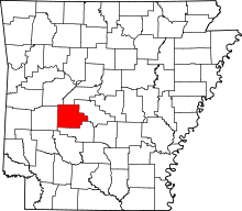 | |
| Towns | ||
| CDPs | ||
| Townships |
| |
| Other unincorporated communities | ||
| Footnotes | ‡This populated place also has portions in an adjacent county or counties | |
Municipalities and communities of Saline County, Arkansas, United States | ||
|---|---|---|
| Cities | 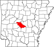 | |
| Towns | ||
| CDPs | ||
| Unincorporated communities | ||
| Footnotes | ‡This populated place also has portions in an adjacent county or counties | |