Izard County, Arkansas
| Izard County, Arkansas | |
|---|---|
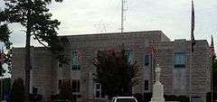 Izard County Courthouse in Melbourne | |
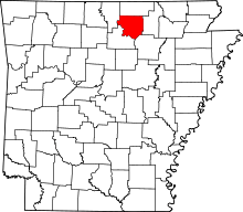 Location in the U.S. state of Arkansas | |
 Arkansas's location in the U.S. | |
| Founded | October 27, 1825 |
| Named for | George Izard |
| Seat | Melbourne |
| Largest city | Horseshoe Bend |
| Area | |
| • Total | 584 sq mi (1,513 km2) |
| • Land | 581 sq mi (1,505 km2) |
| • Water | 3.4 sq mi (9 km2), 0.6% |
| Population (est.) | |
| • (2015) | 13,445 |
| • Density | 24/sq mi (9/km²) |
| Congressional district | 1st |
| Time zone | Central: UTC-6/-5 |
| Website |
www |
Izard County /ˈɪzɜːrd/ is a county located in the U.S. state of Arkansas. As of the 2010 census, the population was 13,696.[1] The county seat is Melbourne.[2] Izard County is Arkansas's thirteenth county, formed on October 27, 1825, and named for War of 1812 General and Arkansas Territorial Governor George Izard.[3] It is an alcohol prohibition or dry county.
Geography
According to the U.S. Census Bureau, the county has a total area of 584 square miles (1,510 km2), of which 581 square miles (1,500 km2) is land and 3.4 square miles (8.8 km2) (0.6%) is water.[4]
Major highways
Adjacent counties
- Fulton County (north)
- Sharp County (east)
- Independence County (southeast)
- Stone County (southwest)
- Baxter County (northwest)
Demographics
| Historical population | |||
|---|---|---|---|
| Census | Pop. | %± | |
| 1830 | 1,266 | — | |
| 1840 | 2,240 | 76.9% | |
| 1850 | 3,213 | 43.4% | |
| 1860 | 7,215 | 124.6% | |
| 1870 | 6,806 | −5.7% | |
| 1880 | 10,857 | 59.5% | |
| 1890 | 13,038 | 20.1% | |
| 1900 | 13,506 | 3.6% | |
| 1910 | 14,561 | 7.8% | |
| 1920 | 13,871 | −4.7% | |
| 1930 | 12,872 | −7.2% | |
| 1940 | 12,834 | −0.3% | |
| 1950 | 9,953 | −22.4% | |
| 1960 | 6,766 | −32.0% | |
| 1970 | 7,381 | 9.1% | |
| 1980 | 10,768 | 45.9% | |
| 1990 | 11,364 | 5.5% | |
| 2000 | 13,249 | 16.6% | |
| 2010 | 13,696 | 3.4% | |
| Est. 2015 | 13,445 | [5] | −1.8% |
| U.S. Decennial Census[6] 1790–1960[7] 1900–1990[8] 1990–2000[9] 2010–2015[1] | |||
As of the 2000 United States Census,[11] there were 13,249 people, 5,440 households, and 3,769 families residing in the county. The population density was 23 people per square mile (9/km²). There were 6,591 housing units at an average density of 11 per square mile (4/km²). The racial makeup of the county was 96.41% White, 1.44% Black or African American, 0.63% Native American, 0.11% Asian, 0.02% Pacific Islander, 0.26% from other races, and 1.13% from two or more races. 1.00% of the population were Hispanic or Latino of any race.
There were 5,440 households out of which 25.50% had children under the age of 18 living with them, 58.70% were married couples living together, 7.50% had a female householder with no husband present, and 30.70% were non-families. 27.80% of all households were made up of individuals and 15.10% had someone living alone who was 65 years of age or older. The average household size was 2.30 and the average family size was 2.78.
In the county the population was spread out with 20.90% under the age of 18, 7.10% from 18 to 24, 25.00% from 25 to 44, 25.80% from 45 to 64, and 21.10% who were 65 years of age or older. The median age was 43 years. For every 100 females there were 102.90 males. For every 100 females age 18 and over, there were 100.90 males.
The median income for a household in the county was $25,670, and the median income for a family was $32,313. Males had a median income of $22,389 versus $18,450 for females. The per capita income for the county was $14,397. About 13.60% of families and 17.20% of the population were below the poverty line, including 22.40% of those under age 18 and 13.70% of those age 65 or over.
Communities
Cities
- Calico Rock
- Horseshoe Bend
- Melbourne (county seat)
- Oxford
Towns
Unincorporated communities
Townships
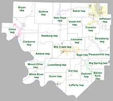
Townships in Arkansas are the divisions of a county. Each township includes unincorporated areas; some may have incorporated cities or towns within part of their boundaries. Arkansas townships have limited purposes in modern times. However, the United States Census does list Arkansas population based on townships (sometimes referred to as "county subdivisions" or "minor civil divisions"). Townships are also of value for historical purposes in terms of genealogical research. Each town or city is within one or more townships in an Arkansas county based on census maps and publications. The townships of Izard County are listed below; listed in parentheses are the cities, towns, and/or census-designated places that are fully or partially inside the township. [12][13]
- Athens
- Baker (small parts of Horseshoe Bend and Oxford)
- Barren Fork (part of Mount Pleasant)
- Big Spring
- Bryan
- Claiborne (small part of Calico Rock)
- Drytown (part of Mount Pleasant)
- Franklin (most of Frankln, small part of Horseshoe Bend)
- Gid
- Guion (Guion)
- Guthrie
- Jefferson (most of Horseshoe Bend, small part of Franklin)
- Lacrosse (part of Melbourne)
- Lafferty
- Lunenberg
- Mill Creek (most of Melbourne)
- Mount Olive
- Newburg (small part of Oxford)
- New Hope (most of Oxford)
- Pleasant Hill
- Sage (part of Melbourne)
- Strawberry
- Union (Pineville, most of Calico Rock)
- Violet Hill
- White River
Source:[14]
See also
- List of lakes in Izard County, Arkansas
- National Register of Historic Places listings in Izard County, Arkansas
References
- 1 2 "State & County QuickFacts". United States Census Bureau. Retrieved May 21, 2014.
- ↑ "Find a County". National Association of Counties. Retrieved 2011-06-07.
- ↑ Gannett, Henry (1905). The Origin of Certain Place Names in the United States. Govt. Print. Off. p. 167.
- ↑ "2010 Census Gazetteer Files". United States Census Bureau. August 22, 2012. Retrieved August 26, 2015.
- ↑ "County Totals Dataset: Population, Population Change and Estimated Components of Population Change: April 1, 2010 to July 1, 2015". Retrieved July 2, 2016.
- ↑ "U.S. Decennial Census". United States Census Bureau. Retrieved August 26, 2015.
- ↑ "Historical Census Browser". University of Virginia Library. Retrieved August 26, 2015.
- ↑ Forstall, Richard L., ed. (March 27, 1995). "Population of Counties by Decennial Census: 1900 to 1990". United States Census Bureau. Retrieved August 26, 2015.
- ↑ "Census 2000 PHC-T-4. Ranking Tables for Counties: 1990 and 2000" (PDF). United States Census Bureau. April 2, 2001. Retrieved August 26, 2015.
- ↑ Based on 2000 census data
- ↑ "American FactFinder". United States Census Bureau. Retrieved 2011-05-14.
- ↑ 2011 Boundary and Annexation Survey (BAS): Izard County, AR (PDF) (Map). U. S. Census Bureau. Retrieved 2011-08-04.
- ↑ "Arkansas: 2010 Census Block Maps - County Subdivision". United States Census Bureau. Retrieved May 29, 2014.
- ↑ "Summary Population and Housing Characteristics, CPH-1-5, Arkansas" (PDF). 2010 Census of Population and Housing. United States Census Bureau. September 2012. Retrieved May 31, 2014. External link in
|work=(help)
External links
 |
Baxter County | Fulton County | | |
| |
Sharp County | |||
| ||||
| | ||||
| Stone County | Independence County |
Municipalities and communities of Izard County, Arkansas, United States | ||
|---|---|---|
| Cities | | |
| Towns | ||
| Unincorporated communities | ||
| Footnotes | ‡This populated place also has portions in an adjacent county or counties | |
Coordinates: 36°6′N 91°54′W / 36.100°N 91.900°W