Arras-en-Lavedan
| Arras-en-Lavedan | ||
|---|---|---|
|
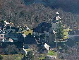
The commune viewed from the Col d'Arras | ||
| ||
 Arras-en-Lavedan | ||
|
Location within Occitanie region  Arras-en-Lavedan | ||
| Coordinates: 42°59′35″N 0°07′33″W / 42.9931°N 0.1258°WCoordinates: 42°59′35″N 0°07′33″W / 42.9931°N 0.1258°W | ||
| Country | France | |
| Region | Occitanie | |
| Department | Hautes-Pyrénées | |
| Arrondissement | Argelès-Gazost | |
| Canton | Aucun | |
| Intercommunality | Val d'Azun | |
| Area1 | 24.66 km2 (9.52 sq mi) | |
| Population (2009)2 | 527 | |
| • Density | 21/km2 (55/sq mi) | |
| Time zone | CET (UTC+1) | |
| • Summer (DST) | CEST (UTC+2) | |
| INSEE/Postal code | 65029 / 65400 | |
| Elevation |
509–2,288 m (1,670–7,507 ft) (avg. 695 m or 2,280 ft) | |
|
1 French Land Register data, which excludes lakes, ponds, glaciers > 1 km² (0.386 sq mi or 247 acres) and river estuaries. 2 Population without double counting: residents of multiple communes (e.g., students and military personnel) only counted once. | ||
.svg.png)
Arras-en-Lavedan is a commune in the Hautes-Pyrénées department in southwestern France.
Population
| Historical population | ||
|---|---|---|
| Year | Pop. | ±% |
| 1962 | 800 | — |
| 1968 | 455 | −43.1% |
| 1975 | 402 | −11.6% |
| 1982 | 418 | +4.0% |
| 1990 | 418 | +0.0% |
| 1999 | 456 | +9.1% |
| 2006 | 539 | +18.2% |
| 2009 | 527 | −2.2% |
See also
References
| Wikimedia Commons has media related to Arras-en-Lavedan. |
This article is issued from Wikipedia - version of the 9/16/2015. The text is available under the Creative Commons Attribution/Share Alike but additional terms may apply for the media files.