Luquet
| Luquet | ||
|---|---|---|
|
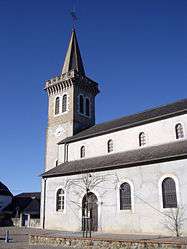
The church of Saint-Laurent | ||
| ||
 Luquet | ||
|
Location within Occitanie region  Luquet | ||
| Coordinates: 43°15′52″N 0°07′04″W / 43.2644°N 0.1178°WCoordinates: 43°15′52″N 0°07′04″W / 43.2644°N 0.1178°W | ||
| Country | France | |
| Region | Occitanie | |
| Department | Hautes-Pyrénées | |
| Arrondissement | Arrondissement of Tarbes | |
| Canton | Canton of Ossun | |
| Intercommunality | Communauté de communes du Canton d'Ossun | |
| Government | ||
| • Mayor (2008–2014) | Hubert Mongoy | |
| Area1 | 8.17 km2 (3.15 sq mi) | |
| Population (1999)2 | 305 | |
| • Density | 37/km2 (97/sq mi) | |
| Time zone | CET (UTC+1) | |
| • Summer (DST) | CEST (UTC+2) | |
| INSEE/Postal code | 65292 / 65320 | |
| Elevation |
346–409 m (1,135–1,342 ft) (avg. 380 m or 1,250 ft) | |
|
1 French Land Register data, which excludes lakes, ponds, glaciers > 1 km² (0.386 sq mi or 247 acres) and river estuaries. 2 Population without double counting: residents of multiple communes (e.g., students and military personnel) only counted once. | ||
.svg.png)
Luquet is a commune in the Hautes-Pyrénées department in south-western France.
Together with Gardères, the commune forms an enclave of Hautes-Pyrénées within the department of Pyrénées-Atlantiques. A neighbouring second enclave comprises the communes of Escaunets, Séron and Villenave-près-Béarn.
See also
References
| Wikimedia Commons has media related to Luquet. |
This article is issued from Wikipedia - version of the 6/25/2015. The text is available under the Creative Commons Attribution/Share Alike but additional terms may apply for the media files.