Les Angles, Hautes-Pyrénées
| Les Angles | ||
|---|---|---|
|
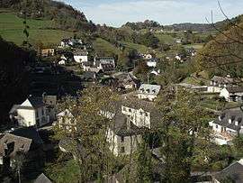
A general view of the village | ||
| ||
 Les Angles | ||
|
Location within Occitanie region  Les Angles | ||
| Coordinates: 43°05′01″N 0°00′27″E / 43.0836°N 0.0075°ECoordinates: 43°05′01″N 0°00′27″E / 43.0836°N 0.0075°E | ||
| Country | France | |
| Region | Occitanie | |
| Department | Hautes-Pyrénées | |
| Arrondissement | Argelès-Gazost | |
| Canton | Lourdes-Est | |
| Intercommunality | Baronnie des Angles | |
| Government | ||
| • Mayor (2008–2014) | Jean Cassou | |
| Area1 | 3.1 km2 (1.2 sq mi) | |
| Population (2009)2 | 125 | |
| • Density | 40/km2 (100/sq mi) | |
| Time zone | CET (UTC+1) | |
| • Summer (DST) | CEST (UTC+2) | |
| INSEE/Postal code | 65011 / 65100 | |
| Elevation |
407–647 m (1,335–2,123 ft) (avg. 400 m or 1,300 ft) | |
|
1 French Land Register data, which excludes lakes, ponds, glaciers > 1 km² (0.386 sq mi or 247 acres) and river estuaries. 2 Population without double counting: residents of multiple communes (e.g., students and military personnel) only counted once. | ||
.svg.png)
Les Angles is a commune in the Hautes-Pyrénées department in southwestern France.
Population
| Historical population | ||
|---|---|---|
| Year | Pop. | ±% |
| 1962 | 140 | — |
| 1968 | 151 | +7.9% |
| 1975 | 130 | −13.9% |
| 1982 | 134 | +3.1% |
| 1990 | 145 | +8.2% |
| 1999 | 141 | −2.8% |
| 2007 | 136 | −3.5% |
| 2009 | 125 | −8.1% |
See also
References
| Wikimedia Commons has media related to Les Angles, Hautes-Pyrénées. |
This article is issued from Wikipedia - version of the 7/20/2016. The text is available under the Creative Commons Attribution/Share Alike but additional terms may apply for the media files.