Louit
| Louit | ||
|---|---|---|
|
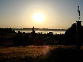
A view of the village in the morning mist | ||
| ||
 Louit | ||
|
Location within Occitanie region  Louit | ||
| Coordinates: 43°18′13″N 0°09′22″E / 43.3036°N 0.1561°ECoordinates: 43°18′13″N 0°09′22″E / 43.3036°N 0.1561°E | ||
| Country | France | |
| Region | Occitanie | |
| Department | Hautes-Pyrénées | |
| Arrondissement | Arrondissement of Tarbes | |
| Canton | Canton of Pouyastruc | |
| Intercommunality | Communauté de communes Riou de Loules | |
| Government | ||
| • Mayor (2008–2014) | André Trinc | |
| Area1 | 5.04 km2 (1.95 sq mi) | |
| Population (1999)2 | 129 | |
| • Density | 26/km2 (66/sq mi) | |
| Time zone | CET (UTC+1) | |
| • Summer (DST) | CEST (UTC+2) | |
| INSEE/Postal code | 65285 / 65350 | |
| Elevation |
240–353 m (787–1,158 ft) (avg. 258 m or 846 ft) | |
|
1 French Land Register data, which excludes lakes, ponds, glaciers > 1 km² (0.386 sq mi or 247 acres) and river estuaries. 2 Population without double counting: residents of multiple communes (e.g., students and military personnel) only counted once. | ||
.svg.png)
Louit is a commune in the Hautes-Pyrénées department in south-western France.
See also
References
| Wikimedia Commons has media related to Louit. |
This article is issued from Wikipedia - version of the 7/14/2014. The text is available under the Creative Commons Attribution/Share Alike but additional terms may apply for the media files.