Bettes
| Bettes | ||
|---|---|---|
|
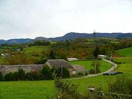
The landscape of Bettes | ||
| ||
 Bettes | ||
|
Location within Occitanie region  Bettes | ||
| Coordinates: 43°04′46″N 0°12′50″E / 43.0794°N 0.2139°ECoordinates: 43°04′46″N 0°12′50″E / 43.0794°N 0.2139°E | ||
| Country | France | |
| Region | Occitanie | |
| Department | Hautes-Pyrénées | |
| Arrondissement | Bagnères-de-Bigorre | |
| Canton | Bagnères-de-Bigorre | |
| Intercommunality | Haute-Bigorre | |
| Government | ||
| • Mayor (2008–2014) | Claude Dorignac | |
| Area1 | 3.38 km2 (1.31 sq mi) | |
| Population (2009)2 | 69 | |
| • Density | 20/km2 (53/sq mi) | |
| Time zone | CET (UTC+1) | |
| • Summer (DST) | CEST (UTC+2) | |
| INSEE/Postal code | 65091 / 65130 | |
| Elevation |
395–723 m (1,296–2,372 ft) (avg. 600 m or 2,000 ft) | |
|
1 French Land Register data, which excludes lakes, ponds, glaciers > 1 km² (0.386 sq mi or 247 acres) and river estuaries. 2 Population without double counting: residents of multiple communes (e.g., students and military personnel) only counted once. | ||
.svg.png)
Bettes is a commune in the Hautes-Pyrénées department in southwestern France.
Population
| Historical population | ||
|---|---|---|
| Year | Pop. | ±% |
| 1962 | 56 | — |
| 1968 | 79 | +41.1% |
| 1975 | 72 | −8.9% |
| 1982 | 76 | +5.6% |
| 1990 | 66 | −13.2% |
| 1999 | 62 | −6.1% |
| 2007 | 74 | +19.4% |
| 2009 | 69 | −6.8% |
See also
References
| Wikimedia Commons has media related to Bettes. |
This article is issued from Wikipedia - version of the 9/17/2015. The text is available under the Creative Commons Attribution/Share Alike but additional terms may apply for the media files.