Hiis
This article is about the settlement in France. For the Estonian sacred place, see Hiis (sacred site).
| Hiis | ||
|---|---|---|
|
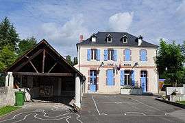
The town hall of Hiis. The building also houses a school. | ||
| ||
 Hiis | ||
|
Location within Occitanie region  Hiis | ||
| Coordinates: 43°08′13″N 0°06′15″E / 43.1369°N 0.1042°ECoordinates: 43°08′13″N 0°06′15″E / 43.1369°N 0.1042°E | ||
| Country | France | |
| Region | Occitanie | |
| Department | Hautes-Pyrénées | |
| Arrondissement | Arrondissement of Tarbes | |
| Canton | Canton of Laloubère | |
| Intercommunality | Communauté de communes Haute-Bigorre | |
| Government | ||
| • Mayor (2008–2014) | Bernard Dhugues | |
| Area1 | 3.03 km2 (1.17 sq mi) | |
| Population (1999)2 | 210 | |
| • Density | 69/km2 (180/sq mi) | |
| Time zone | CET (UTC+1) | |
| • Summer (DST) | CEST (UTC+2) | |
| INSEE/Postal code | 65221 / 65200 | |
| Elevation |
409–579 m (1,342–1,900 ft) (avg. 387 m or 1,270 ft) | |
|
1 French Land Register data, which excludes lakes, ponds, glaciers > 1 km² (0.386 sq mi or 247 acres) and river estuaries. 2 Population without double counting: residents of multiple communes (e.g., students and military personnel) only counted once. | ||
.svg.png)
Hiis is a commune in the Hautes-Pyrénées department in south-western France.
See also
References
| Wikimedia Commons has media related to Hiis. |
This article is issued from Wikipedia - version of the 9/10/2016. The text is available under the Creative Commons Attribution/Share Alike but additional terms may apply for the media files.