Artigueloutan
| Artigueloutan | |
|---|---|
|
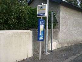
Terminus of Buis route 12 at the Community Hall | |
 Artigueloutan | |
|
Location within Nouvelle-Aquitaine region  Artigueloutan | |
| Coordinates: 43°16′33″N 0°14′42″W / 43.2758°N 0.245°WCoordinates: 43°16′33″N 0°14′42″W / 43.2758°N 0.245°W | |
| Country | France |
| Region | Nouvelle-Aquitaine |
| Department | Pyrénées-Atlantiques |
| Arrondissement | Pau |
| Canton | Pau-Est |
| Intercommunality | Pau-Pyrénées |
| Government | |
| • Mayor (2008–2020) | Michèle Laban-Winograd |
| Area1 | 8.12 km2 (3.14 sq mi) |
| Population (2010)2 | 914 |
| • Density | 110/km2 (290/sq mi) |
| Time zone | CET (UTC+1) |
| • Summer (DST) | CEST (UTC+2) |
| INSEE/Postal code | 64059 / 64420 |
| Elevation |
229–370 m (751–1,214 ft) (avg. 251 m or 823 ft) |
|
1 French Land Register data, which excludes lakes, ponds, glaciers > 1 km² (0.386 sq mi or 247 acres) and river estuaries. 2 Population without double counting: residents of multiple communes (e.g., students and military personnel) only counted once. | |
Artigueloutan is a French commune in the Pyrénées-Atlantiques department in the Nouvelle-Aquitaine region of south-western France.
The inhabitants of the commune are known as Artigueloutanais or Artigueloutanaises.[1][2]
Geography
Artigueloutan is located some 11 km east by south-east of Pau and 9 km south of Morlaàs. Access to the commune is by the D817 from Pau in the west passing through the north of the commune and continuing to Soumoulou in the east. Access to the village is by the D215 road from Assat in the south-west passing through the village and continuing north to Andoins. The D213 comes from Ousse in the west passing through the village and continuing east to Nousty. The commune is entirely farmland.[3]
The Idelis bus line has two stops in the commune: one on route P10 from Pau Auchan to Artigueloutan - Community Hall and the second is Demand responsive transport Flexis Zone Est.
The Ruisseau de l'Ousse passes through the centre of the commune from east to west and continues to join the Gave de Pau at Pau.[3]
Places and Hamlets[4]
Neighbouring communes and villages[3]
 |
Sendets | Andoins | Limendous | |
| Ousse | |
Nousty | ||
| ||||
| | ||||
| Assat | Angais | Gomer |
Toponymy
The name Artigueloutan appears in the forms:
- Artigueloptaa (1385),[5]
- Artigalopta, and Artigelobtaa (14th century,[5] Census of Béarn[6]),
- Arthigueloutan (1457,[7] Notaries of Assat[8]),
- Artigaloutaa (1536,[5] Titles of Affiefdom),
- Artigalotaa (1675,[5] Reformation of Béarn[9]),
- 'Artiguelotaa on the Cassini Map 1750,[7][10] and
- Artigue-Loutan (1801,[11] Bulletin des lois).
Its name in béarnais is Artigalotan (according to the classical norm of Occitan). According to Michel Grosclaude[7] the name comes from the Gascon artigalota, meaning "small cleared land", with the suffix -anam.
A farm at a place called Belloc was mentioned in the Topographic Dictionary of 1863.[12]
Les Bordes, also called Viellelongue, was a hamlet in the commune in 1675,[13] (Reformation of Béarn.[9]
Lou Bouey is an old hamlet in Artigueloutan which has been mentioned with the spellings:
Paul Raymond indicated that there was a Lay Abbey at Lou Bouey, dependent on the Viscounts of Béarn.
Cambus, a farm in Artigueloutan, was also a fief which, in 1538, included the commuens of Ousse and Rontignon, vassal of the Viscounts of Béarn.[16]
Clerguet was a farm and a fief of the commune, vassal of the Viscounts of Béarn, mentioned in 1538.[17]
The Fort de César was a Motte-and-bailey castle in Artigueloutan and Ousse, mentioned in 1863.[18]
Rigabert is the name of a farm mentioned in the dictionary of 1863.[19]
History
Paul Raymond noted that in 1385, Artigueloutan had 28 fires and depended on the bailiwick of Pau.
Administration
List of Successive Mayors[20]
| From | To | Name | Party | Position |
|---|---|---|---|---|
| 1995 | 2001 | Hubert Lassègues | ||
| 2001 | 2020 | Michèle Laban-Winograd |
(Not all data is known)
Inter-communality
The commune is part of seven inter-communal structures:[21]
- the Community of the Agglomeration of Pau-Pyrénées;
- the AEP association of the Ousse Valley;
- the association for the management of the Drainage basin of the Ousse;
- the Energy association of Pyrénées-Atlantiques;
- the inter-communal association for sanitation for the communes of the Ousse plain;
- the inter-communal association for the construction of a rescue centre at Soumoulou;
- the inter-communal association for the construction and operation of the CES at Bizanos.
Demography
In 2010 the commune had 914 inhabitants. The evolution of the number of inhabitants is known from the population censuses conducted in the commune since 1793. From the 21st century, a census of communes with fewer than 10,000 inhabitants is held every five years, unlike larger towns that have a sample survey every year.[Note 1]
| 1793 | 1800 | 1806 | 1821 | 1831 | 1836 | 1841 | 1846 | 1851 |
|---|---|---|---|---|---|---|---|---|
| 403 | 454 | 513 | 518 | 600 | 610 | 700 | 664 | 639 |
| 1856 | 1861 | 1866 | 1872 | 1876 | 1881 | 1886 | 1891 | 1896 |
|---|---|---|---|---|---|---|---|---|
| 717 | 710 | 718 | 691 | 672 | 655 | 646 | 577 | 527 |
| 1901 | 1906 | 1911 | 1921 | 1926 | 1931 | 1936 | 1946 | 1954 |
|---|---|---|---|---|---|---|---|---|
| 524 | 476 | 503 | 405 | 429 | 420 | 401 | 333 | 348 |
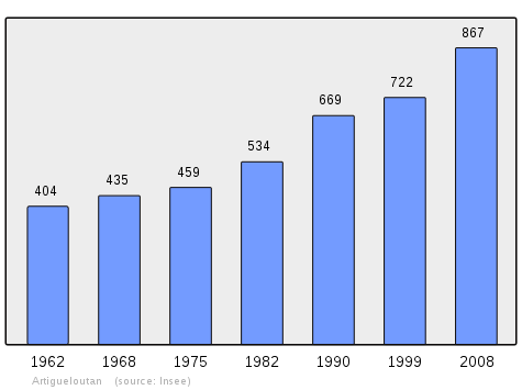
| 1962 | 1968 | 1975 | 1982 | 1990 | 1999 | 2006 | 2010 | - |
|---|---|---|---|---|---|---|---|---|
| 404 | 435 | 459 | 534 | 669 | 722 | 811 | 914 | - |
Sources : Ldh/EHESS/Cassini until 1962, INSEE database from 1968 (population without double counting and municipal population from 2006)
Artigueloutan is part of the Urban area of Pau.
Economy
The commune is partially part of the Appellation d'origine contrôlée (AOC) zone of Ossau-iraty
Culture and heritage
Sites and monuments
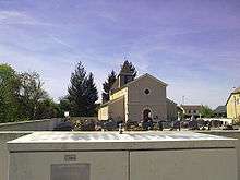
- The Church of Saint John the Baptist dates to the middle of the 19th century. It is registered as a historical monument.[22]
Environmental heritage
The Chemin Henri-IV passes along the south-western border of the commune.[3]
Education
Artigueloutan has a primary school.
See also
- Communes of the Pyrénées-Atlantiques department
- Artigueloutan on the INSEE website (French)
- INSEE (French)
Notes and references
Notes
- ↑ At the beginning of the 21st century, the methods of identification have been modified by Law No. 2002-276 of 27 February 2002, the so-called "law of local democracy" and in particular Title V "census operations" allows, after a transitional period running from 2004 to 2008, the annual publication of the legal population of the different French administrative districts. For communes with a population greater than 10,000 inhabitants, a sample survey is conducted annually, the entire territory of these communes is taken into account at the end of the period of five years. The first "legal population" after 1999 under this new law came into force on 1 January 2009 and was based on the census of 2006.
References
- ↑ Inhabitants of Pyrénées-Atlantiques
- ↑ Brigitte Jobbé-Duval, Dictionary of place names - Pyrénées-Atlantiques, 2009, Archives and Culture, ISBN 978-2-35077-151-9 (French)
- 1 2 3 4 Google Maps
- ↑ Géoportail, IGN, consulted on 12 March 2012 (French)
- 1 2 3 4 5 6 7 8 9 Topographic Dictionary of the Department of Basses-Pyrenees, Paul Raymond, Imprimerie nationale, 1863, Digitised from Lyon Public Library 15 June 2011, p. 14 (French)
- ↑ Manuscript from the 14th century - Departmental Archives of Pyrénées-Atlantiques (French)
- 1 2 3 Michel Grosclaude, Toponymic Dictionary of communes, Béarn, Edicions reclams & Édition Cairn - 2006, 416 pages, ISBN 2 35068 005 3 (French)
- ↑ Notaries of Assat - Departmental Archives of Pyrénées-Atlantiques (French)
- 1 2 Manuscript from the 16th to the 18th centuries - Departmental Archives of Pyrénées-Atlantiques (French)
- ↑ Cassini Map - Arugueloutaa (French)
- ↑ Communal Notice on Ldh/EHESS/Cassini website (French)
- ↑ Topographic Dictionary of the Department of Basses-Pyrenees, p. 27
- ↑ Topographic Dictionary of the Department of Basses-Pyrenees, p. 33
- ↑ Topographic Dictionary of the Department of Basses-Pyrenees, p. 104
- ↑ Cartulary of Ossau or Red Book - Manuscript from the 15th century - Departmental Archives of Pyrénées-Atlantiques (French)
- ↑ Topographic Dictionary of the Department of Basses-Pyrenees, p. 39
- ↑ Topographic Dictionary of the Department of Basses-Pyrenees, p. 51
- ↑ Topographic Dictionary of the Department of Basses-Pyrenees, p. 48
- ↑ Topographic Dictionary of the Department of Basses-Pyrenees, p. 142
- ↑ List of Mayors of France (French)
- ↑ Intercommunality of Pyrénées-Atlantiques, Cellule informatique préfecture 64, consulted on 2 March 2012 (French)
- ↑ French Ministry of Culture Notice IA64000635 Church of St. John the Baptist (French)
| Wikimedia Commons has media related to Artigueloutan. |